Art · Cowpastures · Cultural Heritage · Heritage · History · Local History · Local Studies · Memorial · Memorials · Memory · Monuments · Parks · Place making · Public art · Sculpture · Storytelling · Streetscapes · Uncategorized

Cowpastures Memorial at Narellan

Public art at Narellan Library Plaza

I was walking through the Narellan Library Elyard Street Plaza recently and noticed a Cowpastures Monument.

On investigation, I have found that the artwork was jointly commissioned in 2006 by Camden Council and Narellan Rotary Club.

This image shows the sculpture by Johnson and Topolnicki called Cowpasture Story jointly commissioned by Camden Council and Narellan Rotary Club in 2006 as part of the development of Narellan Library. The project was supervised by Guppy & Associates. (I Willis, 2022)

The artwork is called Cowpasture Story and was created by Blue Mountains artists and sculptors Philippa Johnson and Henryk Topolnicki from Art Is An Option. The artist’s website describes the artwork as ‘Sculptural Mobiles & Screen’.

Artist Philippa Johnson trained at the East Sydney Technical College and the University of Sydney and describes herself as an installation artist, sculptor and painter.  Sculptor and artist Henryk Topolnicki are described as ‘a sculptor, furniture maker and public artist who works principally in metals’. 

The artwork is a series of leaves forming an arch over the path that leads to the front of the Narellan Library. The leaves have a variety of figures representing the settlement of the Cowpastures in early colonial New South Wales. There are depictions of the settler society with cows, settler housing and farms.

The leaves and elements of the Cowpastures Story monument in the Narellan Library Pedestrian Plaza which was commissioned in 2006 by Camden Council and Narellan Rotary Club (2022 I Willis)

The artworks were part of the 2006 Narellan Library development that was designed by Sydney architect GSA, and built by Richard Crookes Construction with art consultants Guppy & Associates.

On the rear of the artwork panels, there are stories about the Cowpastures and the history of the Narellan Rotary Club.

The transcript of the Cowpasture story is located on the back of one of the panels of the artwork. (2022, I Willis)

The story is located on the back of one of the panels.

The elements of the Cowpastures Story monument in the Narellan Library Pedestrian Plaza which was commissioned in 2006 by Camden Council and Narellan Rotary Club (2022, I Willis)

A Brief History of the Cowpastures and its importance to the Narellan/Camden Area

Transcription

The history of the Cowpastures shows the importance to this area of the straying colonial cattle as their discovery led to the early surveying and settlement of the area by the Macarthurs and other colonial landholders. The Cowpastures was ‘discovered’ in 1795, just 7 years after the foundation of the colony.

The Narellan/Camden area was penetrated by white men as far back as 1795. The loss of the early colony’s cattle forms part of the history of New South Wales. These beasts that strayed from Farm Cover led to the discovery and settlement of the Narellan/Camden area. Seven years elapsed after the report of the loss of the cattle before rumours came to Sydney Cove’s settlement of the whereabouts of the missing stock. Governor Hunter dispatched a party under Henry Hacking to confirm or deny the reports of the rumoured cattle.

The results of this party’s investigation so impressed Governor Hunter that he determined to visit the locality to see the cattle and country for himself. With a small party he left Parramatta on the 18th November 1795. After travelling a few days they crossed the Nepean River at a spot where the Camden Cowpasture Bridge now stands and there came across this fine herd.

The name ‘Cowpastures’ by which the locality became known is due to Governor Hunter, for he marked it on a map drawn by himself and dated the 20th August 1796.

In 1802 explorer Barallier journeyed through the area noting the country the cattle had settled in and on the 7th November 1802 passed a swamp called ‘Manhangle’ by the aboriginals. It was this locality that John Macarthur selected land for his future home and for rearing sheep.

In December 1803 Governor King and Mrs King visited the Cowpastures and viewed the straying cattle. The governor instructed that the cattle were to be preserved after attempts were made to cull some of the wild bulls. To bring about the preservation of the cattle a hut was built at Elderslie near the ford of the Nepean River on the southern side. This was the first house in the district and was officially feferred [sic] to as ‘Cowpastures House’. Constables Warby and Jackson were installed there making this not only the first house, but the first police station in the Macarthur District.

Several of the colonial gentry took excursions to see the country so attractive to the cattle and this lead them to acquire property and settle in the area.

The track to the Cowpastures led from Prospect. On the 17th September 1805 James Meehan, under the instruction from the Governor, surveyed the track from Prospect to the Nepean Crossing and a rough road followed. This became the Cowpasture Road, some of which formed part of the old Hume Highway to Camden.

The transcript of the history of Narellan Rotary Club on the back of one of the artwork panels (2022, I Willis)

What is Rotary?

Brief History of the Rotary Club of Narellan Inc.

Transcription

The Rotary Club of Narellan Inc in District 9750, was chartered on the 27th October 1992.

This enabled local business and professional leaders to join a worldwide service organisation to provide social, financial and physical support to the local and international community.

The Rotary Club of Narellan focuses on the Four Avenues of Service in Club, Community, Vocational and International Service and gained recognition within the community as an excellent service club. It has been involved in fundraising for charitable organisations, support of local youth in educational and development program, fostering high ethical standards in business and professions and supporting other charitable organisations.

In fundraising the club raised in excess of $1,000,000 for charities, medical research (in particular Rett Syndrome), international programs and local causes such as Lifeline, Kids of Macarthur Health Foundation and the Salvation Army.

Rotary International has been responsible for the eradication of Polio through a worldwide campaign to which the club has been a major contributor. The Rotary Foundation supports vocational visits between countries and scholars throughout the world, of which the club has regularly hosted.

The elements of the public artwork the Cowpasture Story in the Narellan Library Pedestrian Plaza (2022 I Willis)

Updated 18 July 2022. First Posted 16 July 2022.

Bathtub effect · Floods · Grief · Hawkesbury-Nepean river · Living History · Local History · Local Studies · Macarthur · Memory · Trauma

The rain comes tumbling down, again

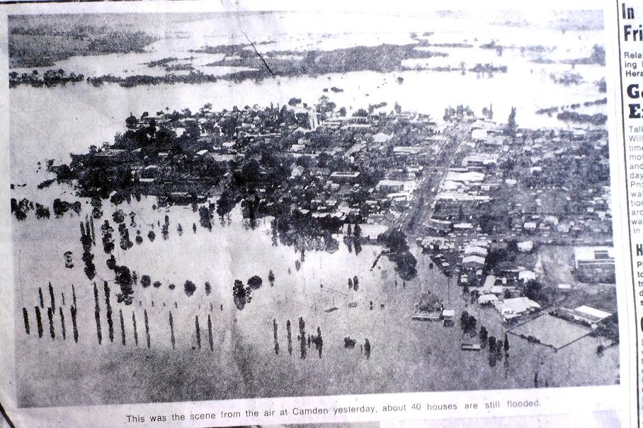
Flooding in the Hawkesbury-Nepean River Valley

As heavy rain fell on my roof this morning, I pondered another forecast for heavy rain and possible flooding in the local area.

The Bureau of Meteorology issued a severe weather warning that stated:

HEAVY RAINFALL For people in Metropolitan, Illawarra and parts of South Coast, Central Tablelands and Southern Tablelands Forecast Districts. (BOM, 2/7/22)

This brings back memories of early 2022 and the effect of local flooding. There is damage to property and people’s mental health.

Flood on Nepean River at Camden next to milk factory looking to Elderslie along Argyle Street in the early 20th century (CIPP)

People become worried about the unknown. So let’s help clear some of the fog.

What is unique about floods on the Hawkesbury-Nepean River?

 The ‘bathtub effect‘ of the Hawkesbury-Nepean River Valley

The Hawkesbury-Nepean River valley has unique landform features that make flooding in the local area perilous.

The river in flood does not behave like other valleys with wide-open flood plains that allow flood water to spread out and slow down.

The Hawkesbury-Nepean River valley has several pinch points constricting the flow and creating upstream localised flooding. This has been termed the ‘bathtub effect’ by engineering geologist Tom Hubble from the University of Sydney in 2021.

The 2019 H-N Valley Regional Flood Study describes the river valley this way:

 The Hawkesbury-Nepean Valley consists of a sequence of floodplains interspersed with incised meanders in sandstone gorges. (ERM Mitchell McCotter, 1995).[p.6]  [ERM Mitchell McCotter, (1995). Proposed Warragamba Flood Mitigation Dam Environmental Impact Statement, Sydney Water, July 1995.]

The Geography Teachers Association has produced an excellent teaching resource about the river valley, and it states:

The unique geomorphic features of the Hawkesbury-Nepean Valley make it particularly vulnerable to dangerous, fast-rising floods.

An aerial view of the Camden township in the 1974 flood event. The Nepean River is behind the town centre and flows from R-L. (SMH)

The NSW SES says:

The Hawkesbury-Nepean Valley has a long history of dangerous and damaging floods. Since records began in the 1790s, there have been over 130 moderate to major floods in the valley, including 6 major and 21 other serious floods since Warragamba Dam was completed in 1960.

So local people have a right to be worried when the BOM issues flood warnings,

Flood trauma is real.

Floods cause a considerable amount of anxiety in the local area.

The New South Wales Governments website Emotional and trauma support after flood states:

Natural disasters, cleaning up and recovery can take a toll on your mental and physical health. It’s vital people seek support and look after their own and their loved ones’ wellbeing. 

Flooding at the Cowpastures Bridge Camden in 2022 (I Willis)

The Black Dog Institute states that after flooding:

We anticipate that Australians living in areas affected by the current New South Wales and Queensland floods are likely to experience psychological distress. While some level of distress is a normal and understandable response to these events, we know from previous disasters that for many this may lead to more chronic mental health problems.

Royal Life Saving Australia says that there is grief and trauma after flooding. It maintains:

Looking after yourself during and following a flood event is an important part of the flood recovery process. If you have lost someone during a recent flooding event, or been rescued, it is especially important to check in with your support network and identify steps to help you get the additional support you may need. Everyone processes grief differently, and there is no one ‘right’ way to grieve, but we all need help in difficult times.

For the nerds

There is a lot of nerdy technical stuff around flooding in the river valley.

Technical details

There is an excellent study called the 2015 Nepean River Flood Study for technically minded people.

The study defines the Upper Nepean as the river upstream of the confluence of the Nepean River with the Warragamba River and is around 1800 square kilometres (p1).

For those who want to read a broader study about flooding across the Hawkesbury-Nepean catchment, I suggest looking at a study called the 2019 Hawkesbury-Nepean Valley Regional Flood Study.

A keen beekeeper and stalwart of the community garden, Steve rescues his hives from flooding in April 2022 (S Cooper)

One local sage, community gardener and flood watcher, Steve, commented on Facebook:

There has been some discussion about the possible rain event on its way [1/7/22]. Happy to report that all upstream dams are below capacity as per the Bureau of Meteorology. The [community] gardens are not affected till 8.5 metres, upstream inflows will be monitored and in the event of water reaching 8 metres livestock will be moved to higher ground within the garden where applicable or externally if required under the guidance of any relevant authorities. Note that the lagoon fills slowly from the river via the old creek line. However, if the river reaches 11 metres Macquarie Road floods over. Flooding has typically peaked in Camden 9 hours after Avon Dam Road peaked and 3 hours after Menangle. The last floods #3 peaked @ 20 metres at Avon Dam Road. The previous #2 at close to 17 metres. Note the last flood 12.2 metres in Camden occurred after all dams were also full.

This information comes from the BOM rain and river data site.

Steve was disappointed in his predictions about the size of the weather event affecting the New South Wales East Coast.

The rainfall at Robertson is a good indicator of what might happen in the Upper Nepean River river valley. Up to 9.00am today (3/7/22), Robertson had received 258mm of rainfall; at Menangle Bridge, there had been 185mm of rain. The Upper Nepean River valley is saturated and partly explains the behaviour of the Nepean River at Camden.

This view shows the Nepean River at Camden from the Elderslie side of the river on the right bank. This image was taken at 10.00am today (3/7/22), and the river was rising. By 3.00pm, the water had risen to the height of the telegraph pole. (2022, I Willis, 3/7/22)

Historic river heights at the Cowpasture Bridge, Camden.

The historical records of flood heights at the Cowpasture Bridge provide an interesting comparison of the present flood. The records are contained in the 2016 Camden Local Flood Plan.

Historic river heights at the Cowpastures Bridge (2016 Camden Local Flood Plan)

Updated 4 July 2022. First posted 2 July 2022.