
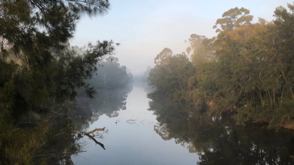
Little Sandy is a sandy spot between the trees, indistinguishable from any other on the Nepean River. What makes Little Sandy special are the stories people enthusiastically tell about the spot, the swimming club, school sports, picnicking, boating, and fishing. and generally mucking around.
Little Sandy holds significant meaning for the local landscape’s intangible cultural heritage. It defines the landscape and the construction of place. It is rich in the memories of local folk who played out their childhoods, experienced the pangs of youth and enjoyed time with their families. Today, thousands of local residents enjoy the same rituals at Little Sandy on their jaunts along the Nepean River bike path with friends and family.

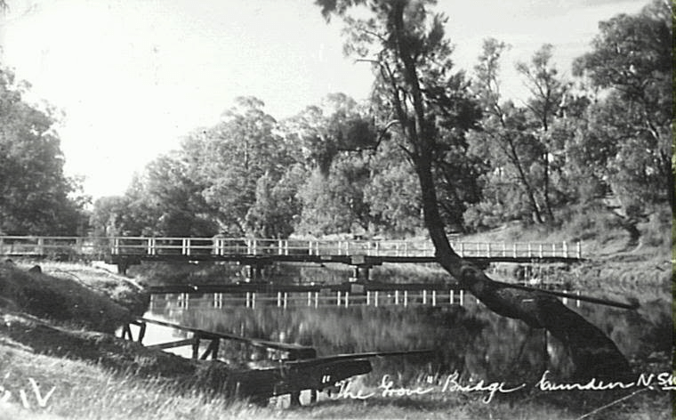
Little Sandy is a well-known spot at the bottom of Chellaston Street, Camden. The construction of Chellaston Street in 1938 provided the community with greater access to Little Sandy. Originally, Chellaston was a single-storey brick residence at 38 Menangle Road, built by Camden builder John Peat and used as his family home. Chellaston Street was part of land releases on the south side of the township in the 1930s. There were several land releases in the area during the Inter-war period, including Victory Ave and Gilbulla Ave, which run off Menangle Road. (Burnett, Nixon & Wrigley, 2005)
In recent decades, Little Sandy has been a concern for local residents over the reconstruction of the footbridge on a number of occasions due to flooding. .
The Nepean River
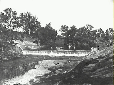
This image of the Nepean River is taken in the vicinity of the Camden Weir. It indicates the river’s degraded state around 1900. Sedimentation and streambank erosion caused by hard-hooved animals trampling river banks were evident. These issues were typical of Australia’s inland waterways in the late 19th century, following extensive clearing of catchments for forestry, farming and other activities.
Sue Rosen, in her book on the environmental history of the Nepean River, quotes from James Atkinson’s 1826 An Account of the State of Agriculture and Grazing in New South Wales. Atkinson states that even by the mid-1820s, the river banks were undermined and collapsing into the stream.
There were deposits of sand in the river channel, and clearing practices had increased runoff, accelerated its degradation, and increased obstruction in the river bed. All is evident in the 1900 photograph of the river channel at Camden.
According to Rosen, ‘the cultivation of a landscape reminiscent of British romantic pastoral scenes’. The earliest reports of the Nepean River date from 1795, and Alan Atkinson’s Camden reports that, after a wet spring, early Europeans. David Collins’s impression in his An Account of the English Colony in New South Wales (London, 1798) was a picture of
‘large ponds, covered with ducks and the black swan, the margins of which were fringed with shrubs of the most delightful tints’.
After a dry spell, the river at Menangle was reported by George Caley in his ‘Report of a Journey to the Cowpastures’ (1804, ML) to be ‘reduced to a small compass’ and the water having ‘the foul appearance of a pond in a farmyard’.
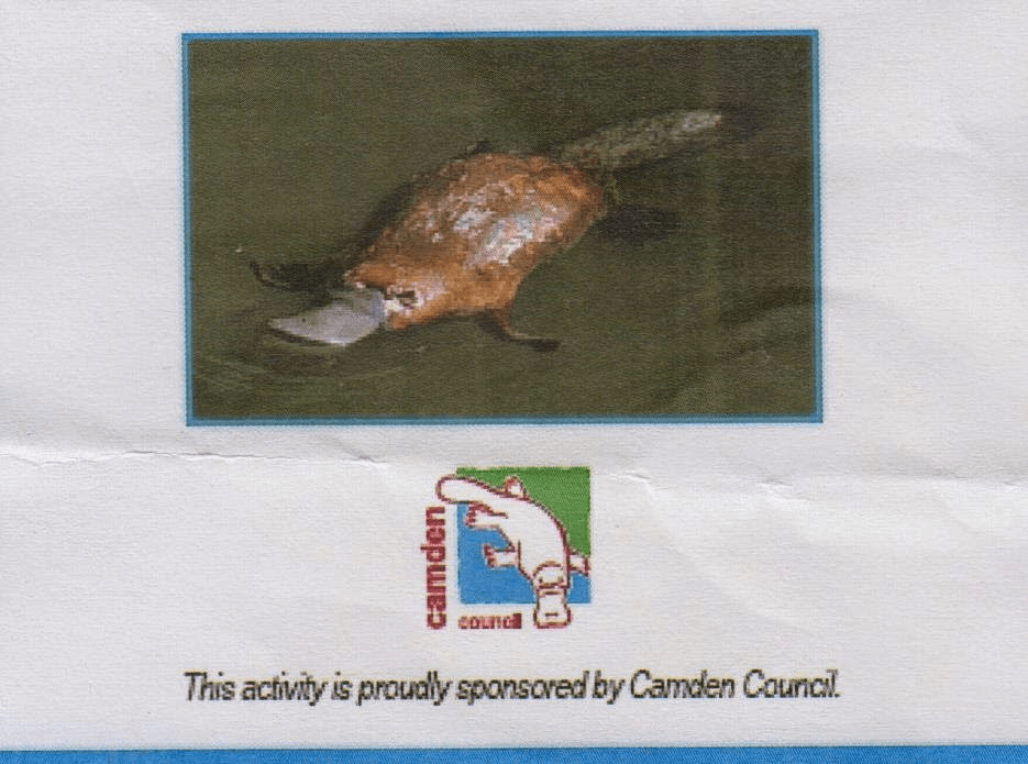
In 2005, Camden Council adopted the platypus as its official logo, and since then, studies have revealed that platypus actually exist in the river today. (CC 2026) In pre-European days, there were platypus in the Nepean River when the river ecology was managed by traditional Indigenous people.
The river created the scenic aesthetic, and the community created the stories.
The Camden Weir
The construction of the Camden Weir in 1908 created the pondage that allowed the development of the story of Little Sandy and its aesthetic, with its moral, experiential, spiritual, and well-being aspects.
The Camden Weir was constructed by the New South Wales Public Works Department after the completion of the Cataract Dam in 1907. The compensation weir was one of a number of weirs built along the Nepean River to safeguard the ‘riparian rights’ of landowners affected by the interruption of flow to the river, according to John Wrigley.
A riparian right is the ability to take water from the river. The water supply dams of the Upper Nepean Scheme reduced the flow of the tributaries of the Nepean River, and the weirs were to ‘compensate’ for the loss of water flow.
The other weirs near Camden were Menangle, Bergins, Thurns, Camden Sharpes and Cobbitty. The weirs were eventually transferred to the Metropolitan Water Sewerage and Drainage Board’s management as part of the Sydney Water Supply system. (Wrigley 2001)
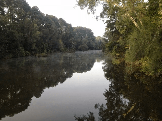
The Little Sandy pondage creates an attractive water feature that circles the township. Water has a calming effect on the mind and takes the account to a quiet, tranquil and peaceful place. For others, a visually attractive water feature can also be a source of healing and relaxation in a man-made environment. At dawn, the river is like a mirror, and on a cold, frosty morning, the vapours of the steam rise from the water’s surface as the walker’s feet crackle under the frozen grass on the water’s edge.
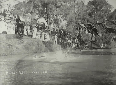
Those who went swimming at Little Sandy had an experiential relationship with the water. Water is used to nourish and replenish man after exertion. Swimming carnivals were a time of community celebration and strengthening community resilience.
The pondage at Littles Sandy also has a scientific value for the marine ecosystem it supports. It supports a range of life, from eels and perch to birds, reptiles, and other species. There is a splash as a kingfisher dives into the water after a fish, which breaks the silence of the space. The world disappears momentarily as you sit on the water’s edge, taking in the serene quiet surroundings of the pond.
Swimming carnivals
In the early 20th century, Little Sandy became a favourite swimming spot following the construction of the Camden weir. In the 1920s, the Camden Swimming Club built green-painted galvanised-iron dressing sheds in an area now known as Kings Bush Reserve.
Swimming became one of Elderslie’s earliest organised sporting activities after the Nepean River was dammed by the Camden Weir. Water backed up behind the weir for four kilometres through the Elderslie area, providing relatively deep water suitable for swimming.
The Camden Aquatic Sports carnival was organised in 1909 and attracted over 1000 spectators, and was the location of the Camden Swimming Club in the 1920s.
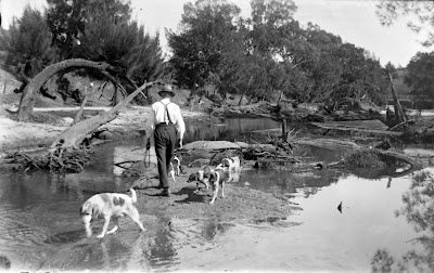
The area was divided into Big Sandy, a deep hole near Kings Bush Reserve. About 100 metres upstream was Little Sandy, where the water was shallower. Learn-to-swim classes were held briefly, and Boy Scouts would swim there, according to Milton Ray.
“In the 1950s, the area was used for swimming by pupils from Camden Public School’, said Len English. ‘The girls went with the female teachers to Little Sandy, while the male teachers and boys went downstream to Camden Weir.’
Olive McAleer says, ‘Little Sandy was a popular spot for family picnics between the 1920s and 1940s’.
The river stopped being a swimming spot when it was condemned because of pollution by medical authorities in the early 1960s. It was replaced by the Camden Memorial Swimming Pool in 1964. (Mylrea 2006) The closure of the river swimming only enhanced the stories of Little Sandy, just like another famous spot on the river, Kings Bush.
Kings Bush
King’s Bush is the reserve adjacent to Little Sandy. It is on the rver’s edge and is named after Cecil J King, the rector of St John’s Church between 1893 and 1927. According to John Wrigley, King kept his horse in the paddock next to the river and swam at the same spot in the river.
The 1943 Little Sandy footbridge
In 1943, military authorities at the Narellan Military Camp were anxious to conduct a practical training exercise for engineers. In September, they sought the Camden Municipal Council’s view on erecting a footbridge, and the council immediately agreed with the proposal.
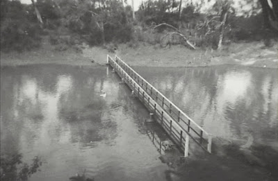
The council covered the cost of some of the timber, so the bridge remained the council’s property. The Australian Military Forces’ Engineers supplied the labour, supervision, transport vehicles, and operators for the transport of stores and construction materials.

The site at the bottom of Chellaston Street connected two reserves on either side of the Nepean River. One on the Chellaston Street side and the other at River Road, Elderslie.
In late September 1943, 40 troops started building a wooden footbridge 120 feet long and 4 feet wide. Construction took around four weeks and was finished by 28 October.
Observers commented on a ‘fine piece of workmanship…that would be much appreciated’ by the local community. (Camden News, 16 September 1943, 23 September 1943, 28 October 1943).
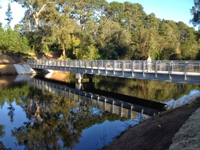
New footbridge
The new pre-cast concrete 43-metre footbridge at Little Sandy on the Nepean River was completed in April 2014. Camden Council let contracts for the completion of a new footbridge in September 2013.
The new structure replaced a wooden footbridge that was damaged in a flood in 2012. The new footbridge was jointly funded by the council and the state government.
The finished footbridge is part of the Nepean River cycleway, which links Camden with Elderslie, South Camden and Narellan. Local resident Kevin Browne stated in 2012 (Camden Narellan Advertiser 31 July 2012) that:
the bridge was part of the unique attraction of living in a rural area [and] the availability of serene, natural beauty.
After the 2012 damage to the footbridge and its subsequent closure, local residents began campaigning for its replacement. This culminated in a community meeting in the mayor’s office in August 2013 when 19 local residents attended an information session with the mayor, the Member for Camden, and the council’s general manager and engineering staff.
Opening of the new footbridge in 2014
The Little Sandy footbridge was officially opened on 4 May 2014 with another community event. The weather gods were kind: while there was a cool breeze and an overcast start, the sun came out, and the crowd turned up with families of mums, dads, and kids.
Camden Council organised a family fun day at Chellaston Reserve, featuring stalls, a free train ride along the bike track, and information stands. The day opened at 11.00am and wound up at 3.00pm. Camden Rotary provided a sausage sizzle, which sold out early in the day. An information stand was provided by the Camden Historical Society, staffed by volunteers John and Julie Wrigley, Bob Lester, and Rene Rem, with others turning up later. This was another community event typical of the site’s popularity with the Camden community.
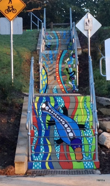
Public art at Little Sandy
The steps adjacent to the Little Sandy footbridge feature Aboriginal-inspired artwork. Press reports stated that it pays tribute to the Camden Council logo of a platypus and celebrates the flora and fauna of the area.
Artist Danielle Mate, who grew up in Camden and has Aboriginal heritage, is pleased with the work. According to reports, she consulted the Mygunyah Camden Aboriginal Residents Group before starting the project. Mayor Symkowiak reportedly said it was a ‘great addition’ to the area. (Macarthur Chronicle Camden Edition 19 May 2015)
A tranquil water view
The Nepean River has provided poetic inspiration for paintings, sketches, and storytelling. For example, Joseph Lycett (c. 1825) created View upon the Nepean River, at the Cow Pastures, a hand-coloured etching showing the river landscape. The Camden Public Art Trail is a modern, 15-artist trail featuring murals and sculptures, such as the SENTINEL – Camden White Gum, which tells the story of local site ecology and the Nepean’s seasonal rhythms.
The river has been at the heart of Camden’s identity and an integral part of the district’s social heritage. The Nepean River is one element of the area’s intangible cultural heritage. Unfortunately, Australia is not a signatory to the United Nations Convention for the Safeguarding of the Intangible Cultural Heritage. (Paris, 17 October 2003)
The geography of the Nepean River and its floodplain has shaped the area’s landscape. The river floodplain is the site of many community celebrations, traditions, and rituals, including the Camden Show and Anzac Day.
Conclusion
Little Sandy is a special place on the Nepean River at Camden, and locals tell lots of stories. Little Sandy is embedded in their memory for lots of firsts. First kiss, first swim, first fish and other firsts that are mileposts in local lifetimes. It is a vague spot at the bottom of Chellaston Street, Camden, indistinguishable from any other spot on the river, which is part of its appeal. Lots more stories will be generated at Little Sandy over the coming years when future generations have their own adventures at this iconic spot on the river.
The river catchment is the most important in the Sydney basin and has significant cultural significance in the area. Little Sandy has remnants of Cumberland Woodland in the gallery forest along the river’s edge, which once covered much of the local area.
Little Sandy, located on the Nepean River in Camden, holds a special place in local history, serving as a nostalgic swimming spot enriched with memories of community gatherings and personal milestones. Originally enhanced by the Camden Weir, it now features a modern footbridge and showcases Aboriginal-inspired artwork, reflecting its cultural significance and ongoing legacy.
What stories can you tell about Little Sandy? What have you done at Little Sandy? How many times do you visit it? What is special about Little Sandy for you?
References
Atkinson, Alan 1988. Camden, Farm and Village Life in Early New South Wales, Melbourne, OUP.
Burnett, Brian, Nixon, Richard E & Wrigley, J. D. 2005, Place names of the Camden area. Camden Historical Society and the Camden Area Family History Society. Camden Historical Society, Camden, N.S.W.
CC 2026. Platypus. Camden Council, Oran Park. Online at https://www.camden.nsw.gov.au/environment/biodiversity/native-animals/platypus Accessed 10/4/26
Mylrea, Peter, 2006. ‘Swimming in the Nepean River at Camden’, Camden History, March 2006, v2, n1.
Rosen, Sue 1995. Losing Ground: An Environmental History of the Hawkesbury-Nepean Catchment, Sydney: Hale & Iremonger.
Willis, Ian 2008. Elderslie, Dictionary of Sydney. https://dictionaryofsydney.org/entry/elderslie , viewed 10 Apr 2026
Wrigley, John 2001. ‘ Nepean River Weirs’, The District Reporter, 3 August 2001
Posted here 13 April 2026. Originally posted 29 May 2015 in Google Blogger as ‘Little Sandy, more than a footbridge and a water view‘ on 29 May 2015.
Discover more from Camden History Notes
Subscribe to get the latest posts sent to your email.

