

The mystery of this story deepens with more contradictions and mysteries emerging daily. As evidence emerges and is verified, this post will be updated.
The mystery of the John Oxley Memorial anchor.
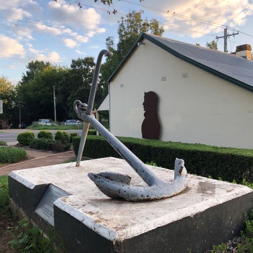
As visitors approach the Camden town centre along Camden Valley Way at Elderslie, they pass Curry Reserve, which has a quaint late 19th-century workman’s cottage and, next to it, a ship’s anchor. What is not readily known is that the anchor disappeared for 34 years. What happened? How did it become lost for 34 years? How did it end up in a park on Camden Valley Way?
The cottage is known as John Oxley Cottage and is the home of the local tourist information office. The anchor is a memorial gift to the Camden community from British naval authorities on the anniversary of the death of noted Englishman and New South Wales colonial identity John Oxley. So, who was John Oxley, and why is there a memorial anchor?
This tale could also be viewed as celebrating European invaders displacing and dispossessing the Indigenous Dharawal people from their country. Englishman and colonial identity John Oxley was part of the colonial settler society, which, according to LeFevre, sought to replace the original population of the colonized territory with a new society of settlers.
Whichever view of the world you want to take, this tale is an example of how the past hides many things, sometimes in plain view. This story is one of those hidden mysteries from the past and is also part of the patina of the broader Camden story.
John Oxley Memorial Anchor
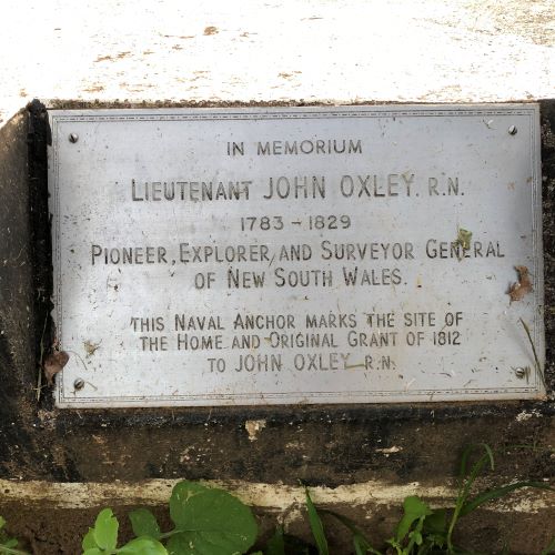
Next to the anchor in Curry Reserve is the Oxley Memorial plaque, which states:
In Memorium
Lieutenant John Oxley RN
1783-1829
Pioneer, Explorer and Surveyor General of New South Wales.
This Navel Anchor marks the site of the home and original grant of 1812 to John Oxley RN.
Camden Council relocated the anchor to Curry Reserve in Elderslie in 2015 from a privately owned site in Kirkham Lane adjacent to the Kirkham Stables. The council press release stated that the purpose of the move was to provide
greater access for the community and visitors to enjoy this special piece of the past.
Mayor Symkowiak said:
The anchor represents an important part of our history and [the council] is pleased that the community can now enjoy it in one of Camden’s most popular parks.
We are pleased to work with Camden Historical Society in its relocation to Curry Reserve. The society will provide in-kind support through the provision of a story board depicting the history of the anchor.
The anchor was initially located in Kirkham Lane adjacent to Kirkham Stables in 1963. According to The Australian Surveyor, there had been an official ceremony where a descendant of John Oxley, Mollie Oxley, of Cremorne Point, NSW, unveiled the plaque. The report states that around 20 direct descendants of John Oxley were present at the ceremony organised by the Camden Historical Society. (The Australian Surveyor, September 1963, p. 427)
British naval authorities had initially handed over the anchor to the Camden community in 1929. So what happened between 1929 and 1963?
The answer to this mystery is explained in the 60th-anniversary address given by the 2017 Camden Historical Society president, Dr Ian Willis. He stated that shortly after the society was founded in 1957, Camden Council was lobbied to do something with the anchor that
[had] languished in the council yard all but forgotten.
In 1929 the British Admiralty presented the anchor to the Camden community to commemorate the centenary of the death of Englishman and New South Wales colonial identity John Oxley. (https://adb.anu.edu.au/biography/oxley-john-joseph-2530)
The British Admiralty presented three commemorative anchors to Australia to serve as memorials. The Sydney Morning Herald reported:
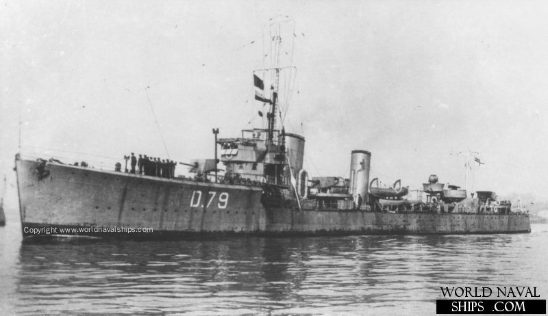
One anchor, from the destroyer Tenacious, is to be sent to Wellington, where Oxley heard of the victory at Waterloo. A second anchor, from the minesweeper Ford, will to Harrington, to mark the spot where Oxley crossed the Manning River. The third anchor is from the destroyer Tomahawk, and will go to Kirkham, near Camden, where the explorer died. (SMH 7 March 1929)
The HMS Tomahawk was one of sixty-seven “S” class destroyers built for the Royal Navy as the Great War ended. The ship was built in 1918 and reduced to the naval reserve list in 1923. (http://www.dreadnoughtproject.org/tfs/index.php/%22S%22_Class_Destroyer_(1918))
What about the other two anchors?
Harrington, NSW
The mystery of the Oxley anchors deepens. According to the Monument Australia website, the plaque on the anchor at Harrington claims that their anchor comes from the HMS Tomahawk. This contradicts the story of the Camden Oxley anchor.
The monument was erected in 1968 to commemorate the sesqui-centenary of Harrington NSW. Two information boards were added to the bicentenary of Harrington in 2018. (https://monumentaustralia.org.au/search/display/113157-john-oxley-)
In 1929, ‘a fair crowd’ witnessed the unveiling of the Oxley Memorial by Mrs Martin, the wife of the UAP Member for Oxley, Lewis O Martin MLA. There were speeches and several apologies, including one from Aubrey Halloran of the Royal Australian Historical Society. The Wingham band played the national anthem, and a ‘basket picnic’ was held on the school grounds. (The Northern Champion (Taree), 18 September 1929)
The report in The Northern Champion maintained that the anchor came from HMS Tomahawk, weighed 5 cwt, with a length of 6ft 6in. Initially, Manning Shire Council approached TG Adamson of Greenwich, who had a special interest in erecting Oxley memorials, about acquiring an anchor from the British Admiralty, who were making anchors ‘available’ at the time. (The Northern Champion (Taree), 18 September 1929)
The memorial plinth was designed by Manning Shire Council Engineer RJ Montgomery, who supervised the construction. The plaque cost £22/10/-, and the construction of the memorial cost £36/14/11d. (The Northern Champion (Taree), 18 September 1929)
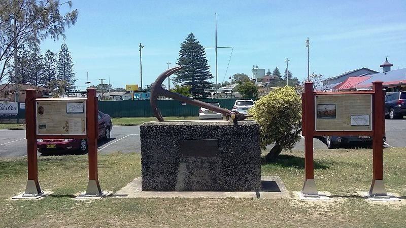
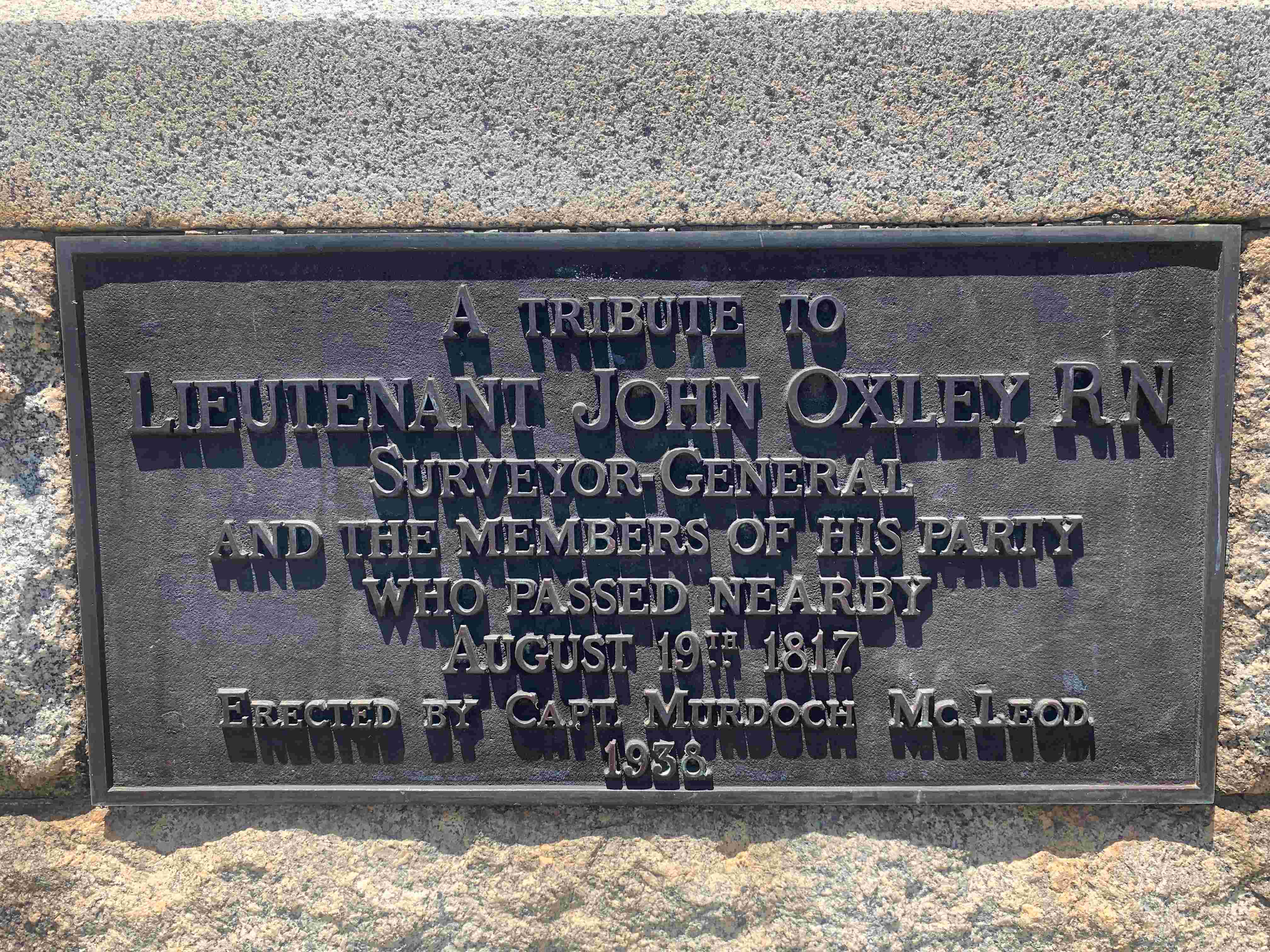
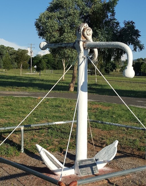
Wellington NSW
The third anchor is to be found in the grounds of the Wellington Public School, Percy Street, Wellington and was erected in 1938 as the Oxley Anchor Memorial. The Wellington anchor was donated to the then Wellington Intermediate High School by former Wellington businessman Murdoch McLeod of Manly. The anchor can be viewed from Percy Street in the front of the school.

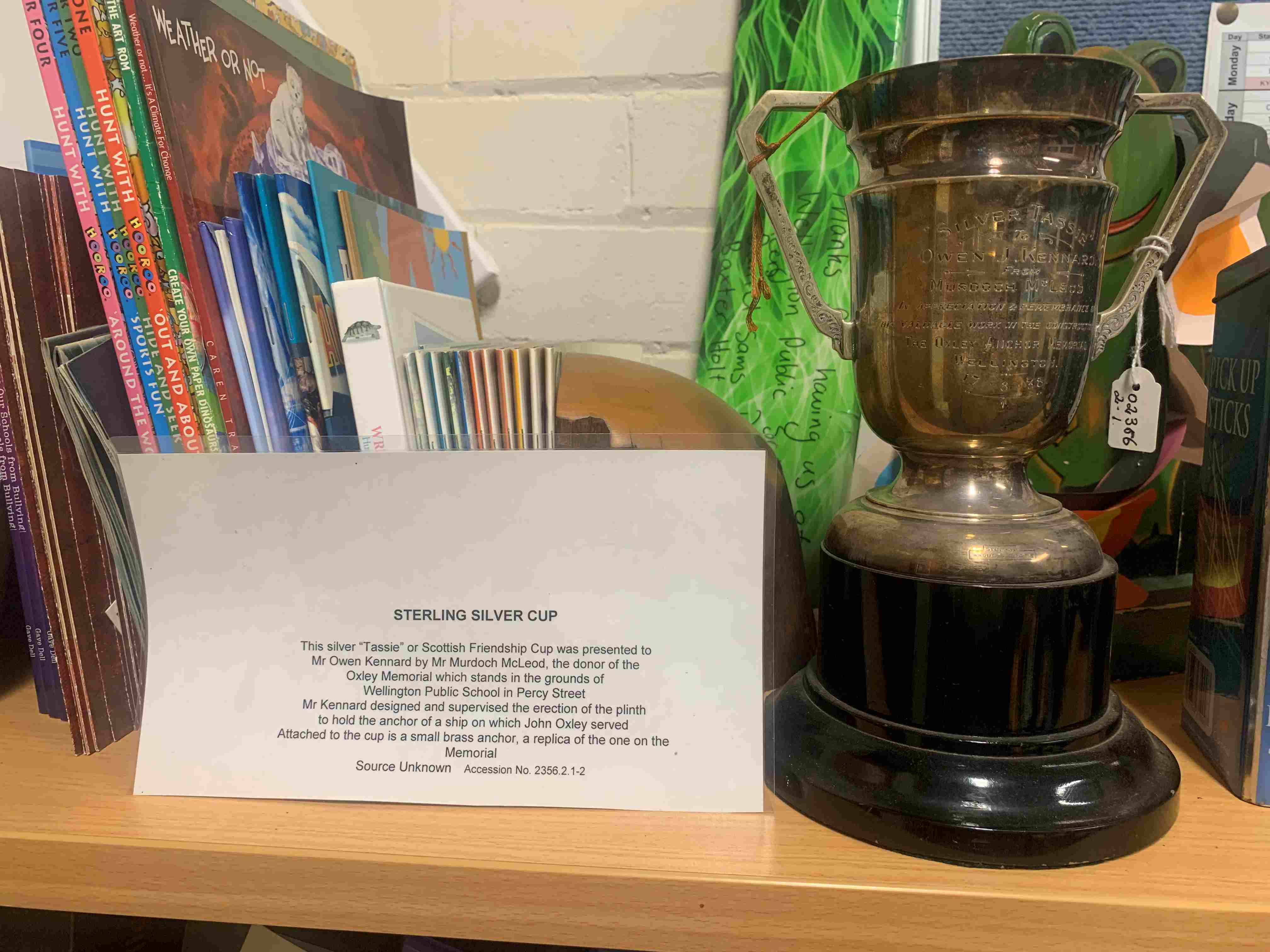
The Oxley Anchor Memorial was donated to the Wellington Intermediate High School by former Wellington businessman, mill owner and philanthropist Murdoch McLeod. Wellington architect and builder Owen Kennard designed and constructed the Oxley Anchor Memorial for McLeod. (Wellington Times, 16 November 1950) To honour this, McLeod gave Kennard a silver Scottish Friendship Cup, now in possession of Wellington Public School.
Another anchor
Hallsville (Tamworth) NSW
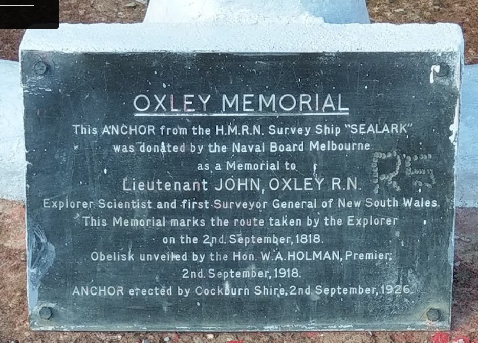
In 1918, a plaque was unveiled on a British Naval anchor at the corner of Manilla and Anchor Roads, Hallsville (Tamworth), NSW, to celebrate the Oxley’s crossing of the Peel River in 1818. The crossing occurred during Oxley’s 1818 expedition, initially leaving Bathurst in May.
The Hallsville anchor was from HM survey ship Sealark. The monument was unveiled by the NSW Premier, WA Holman, in 1918 on the centenary of the crossing of the Peel River.
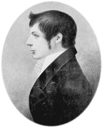
John Oxley, the man
The Australian Surveyor noted that Oxley came to New South Wales on the HMS Buffalo in 1802 as a midshipman, returned to England in 1807, gained his lieutenancy, and returned to New South Wales in 1809. Oxley returned to England in 1810, was appointed New South Wales Surveyor-General in 1812, and returned to the colony.
Oxley was born in Kirkham Abbey in Yorkshire, England and enlisted in the Royal Navy in 1802, aged 16.

John Oxley was allocated the grants of Kirkham in 1812 (later Camelot) and Elderslie in the Cowpastures district. He had several convicts assigned to him who worked at the property of Kirkham.
As Surveyor-General Oxley led several expeditions into the New South Wales interior, he was also active in the public affairs of the colony.
John Oxley Reserve
The sculpture of Oxley’s profile had been originally erected in John Oxley Reserve in Macquarie Grove Road at Kirkham in 2012 after lobbying by the Camden Historical Society. The metal cut-out silhouette was commissioned by Camden Council at the instigation of Robert Wheeler of the society. The sculpture commemorated the bi-centennial anniversary of Oxley’s appointment as surveyor-general to the New South Wales colony.
Mayor Greg Warren said:
John Oxley was a major part of Camden’s history. The signage and silhoutte will be a continual reminder of [his] significant contribution to the Camden area. (Camden Narellan Advertiser 20 June 2012)
John Oxley Cottage
The John Oxley Cottage is the only remaining building from a row of workman’s cottages built in the 1890s along what was the Great South Road, later the Hume Highway (1928) and now the Camden Valley Way.

The Visitor Information Centre was opened in 1989 after the cottage and its surrounding curtilage were purchased by Camden Council in 1988 and added to Curry Reserve. The cottage was originally owned by the Curry family and had been occupied until the late 1970s, then became derelict.
The four-room cottage had a shingle roof later covered in corrugated iron. Several outbuildings, including a bathroom and toilet, alongside a well.
Curry Reserve is named after early settler Patrick Curry, the Camden waterman in the 1840s. He delivered water he drew from the Nepean River to the townsfolk for 2/- a load he transported in a wooden barrel on a horse-drawn cart.
John Oxley is remembered in lots of places
Oxley Street in the Camden Town Centre was named after Oxley at the foundation of the Camden township in 1840.
An obelisk has been erected by the residents of Redcliffe that commemorates the landing of Surveyor-General Lieutenant John Oxley. In 1823, on instructions from Governor Brisbane, John Oxley was sent to find a suitable place for a northern convict outpost.
There are more monuments to the 1824 landing of John Oxley and his discovery of freshwater at North Quay and Milton in the Brisbane area.
An anchor commemorates John Oxley’s route in his exploration of New South Wales in 1818 and marks where Oxley crossed the Peel River in 1818 outside Tamworth. In 2017 the anchor was targeted as a symbol of settler colonialism and the European invasion of the lands of the Wiradjuri people. The anchor was obtained from the Australian Commonwealth Naval Department and came off the British survey ship HMS Sealark.
A monument, the anchor from the HMS Ford from British naval authorities, was erected at Harrington NSW in honour of explorer John Oxley who explored the area from Bathurst to Port Macquarie. Oxley and his 15 men crossed the Manning River on 22 October 1818, having stayed here from 19 October in the lands of the Biripi people.
There is John Oxley Park in Wellington, NSW, on the Macquarie River on the land of the Wiradjuri people. Wellington was named after the explorer John Oxley who, according to the popular story, could not cross the Lachlan River because of dense reeds. He climbed Mount Arthur in 1817 and named the entire landscape below him Wellington Valley after the Duke of Wellington, who, only two years earlier, had defeated Napoleon at Waterloo.
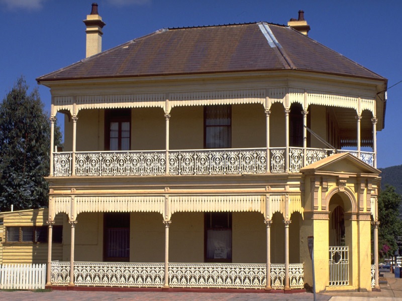
The Oxley Historical Museum is housed in the old Bank of New South Wales, on the corner of Warne and Percy Streets, in a glorious 1883 Victorian-era two-story brick building designed by architect J. J. Hilly. Today, Wellington’s Oxley anchor memorial is found on the grounds of the Wellington Public School.
Notes
The author thanks Alana Stone, Wellington Public School, for the information and photographs supplied in this post.
Updated 19 December 2024; originally posted 27 March 2020 as ‘Oxley’s Anchor away for 34 years’.
Discover more from Camden History Notes
Subscribe to get the latest posts sent to your email.


3 thoughts on “John Oxley’s anchor lost for 34 years”
Comments are closed.