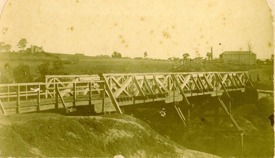
1973 New Cities Campbelltown Camden Appin Structure Plan · Argyle Street · Bridges · Camden · Camden Bridge · Camden Story · Colonial Camden · Community identity · Cowpastures · Cowpastures River · Cultural Heritage · Economy · Engineering Heritage · Engineering History · Floods · Frontier violence · Governor Macquarie · Heritage · History · Hume Highway · Industrial Heritage · Infrastructure · Living History · Local History · Macarthur · Memorial · Memorialisation · Memorials · Monuments · Motoring History · Nepean River · Place making · Placemaking · Railway · Sense of place · Technology · Transport · Travel · Urban history · Utilities

The Cowpastures bridge at the Nepean River crossing

Four bridges at the river crossing

Walking over the Cowpastures bridge, you have a vista of the tranquil water of the Nepean River impounded behind the Camden weir. The tranquillity belies the raging torrent that can cover the bridge at flood times.

Plaque located in the Rotary Cowpasture Reserve in Argyle Street Camden adjacent to the Cowpasture Bridge commemorating the opening of the reconstructed bridge after the 1975 flood (I Willis 2021)

On the bridge’s western end is a small park where a plaque celebrates the 1976 reconstruction of the bridge. A flood had turned the timber bridge deck into a twisted mess twelve months earlier.

The plaque states:

Cowpasture Bridge

Originally opened in 1901 this bridge was extensively damaged by flood in June 1975.

Following repair it was re-opened by The Hon J JC Bruxner MLA, Minister for Transport and Highways, 9th April 1976.

Ald RB Ferguson, Mayor. Camden Municipal Council.

REA Rofe Esq. MLA, Member for State Electorate of Nepean.

AF Schmidt Esq., Commissioner for Main Roads, New South Wales.

Plaque, Argyle Street, Camden.

The twisted Cowpasture bridge timber deck after the 1975 flood closed access across the river for many months. (Camden Images)

Choke-point

The low-level Cowpasture bridge is a pinch point for moving goods and people across the river. Its closure at flood times has created a choke-point that disrupts daily life. Other low-level bridges in the local area at Menangle, Cobbitty, and Macquarie Grove Road have suffered the same problem.

The eastern approach to the Cowpastures Bridge on Camden Valley Way with signage for the Cowpasture Bridge in the early morning (I Willis, 2017)

The access issue was only solved with the opening of the high-level Macarthur Bridge in 1973. The bridge is an essential example of Camden’s engineering heritage and was built as part of the local region’s NSW Askin Governments New Cities structure plan.

Economic importance of access

Access to the southern side of the Nepean River has been an issue since European settlement and the discovery of Wild Cattle in 1795. Governor Hunter named the Cowpastures in 1796, and it became a restricted reserve in 1803 to stop cattle poaching.

The issue of access across the river was illustrated in 1810 when a party led by Governor Macquarie visited the area.   Macquarie wrote in his journal on 16 November 1810:

There being very little Water in the River at this time, we crossed it at the usual Ford in our Carriage with great ease and safety.

A bridge at last – ‘a paltry affair’

As the colonial frontier moved beyond the Cowpastures, there was increased traffic across the Nepean River, sometimes reported as the Cowpastures River. (SMH, 2 October 1861). The frontier conflicts between Europeans and Indigenous people calmed on the Cowpastures after the 1816 massacre. (Karskens, 2015) The process of settler colonialism and its insatiable appetite for territory increased traffic through the Cowpastures in the 1820s.

The river crossing required a more permanent solution for the increased traffic along the Great South Road. The first Cowpasture bridge was built in 1826, and then new bridges followed in 1861, 1900 and 1976. Each tried to solve the same access problem (SMH, 2 October 1861).

This sketch of the 1826 Cowpasture Bridge was attributed to Thomas Wore of Harrington Grove in 1842. St John’s Church is on the hill consecrated in 1849. Historic Sketch Discovered: Camden Village in 1842, The Sydney Morning Herald, Saturday, 10 June 1933, p.9 (illustrated is a previously unpublished sketch of an almost identical drawing to (Cowpastures) Bridge & Village of Camden.) http://trove.nla.gov.au/ndp/del/page/1151602

A low-level bridge was first raised in 1823 when Surveyor-General John Oxley of Kirkham objected to a bridge at Bird’s Eye Corner river crossing (Menangle). The final decision was to build a crossing halfway between the Belgenny Crossing and Oxley’s Macquarie Grove. (Villy, 62-63)

Work began on the low-level Cowpasture bridge in 1824 and finished in 1826. Construction was supervised by convict Samuel Wainwright and built below the crown of the riverbank. There was no shortage of sceptics, and a band of local ‘gentlemen’ thought the bridge would collapse in the 1826 flood. (Villy, 62-63) They were wrong.  

A convict was stationed at the bridge as a caretaker to remove the bridge rails in flood. In 1827 a toll was introduced on the bridge, with the right-to-collect sold for £70. Crossing the bridge on a Sunday was forbidden; offenders were fined and cattle impounded. (Starr, 16-17)

Repairs were carried out on the bridge after floods in 1835 (Starr: 17), and in the 1840s ‘landowners, carriers and mail contractors’ complained. They were concerned that the bridge was submerged by floodwater ‘on every occasion’ and in a recent deluge, ‘the Bridge was sixteen feet underwater and the neighbouring flats, a complete sea for miles’. (Starr: 17)

Several memoirs described the bridge as ‘a very a paltry affair’ (Starr: 23) and a ‘primitive structure’ (Sydney Mail, 5 February 1913). 

In 1852 a portion of the bridge washed away, and there were terrible floods in February and April 1860. There was a need to replace the ‘dilapidated’ bridge. (SMH, 2 October 1861)

The timber truss Camden Bridge across the Nepean River with Thompson’s Woollen Mill on the right of the image in 1861. (Camden Images)

Tenders were called in early-1860 for a new five-span timber truss bridge (NSW Government Gazette, 6 April 1860), and it was under construction by September. The construction tender was won by Campbelltown building contractors Cobb and Bocking (SMH, 21 September 1860; SMH, 2 October 1861), who also built the low-level timber truss bridge at Menangle in 1855. (RMSHC, 2019; Liston, 85)

A grand affair

There was much fanfare at the new bridge opening on Monday, 30 September 1861, at 3 pm. There was conjecture about the crowd size. The Empire claimed a crowd of 50 people, while the Sydney Morning Herald boasted 200 present. (Empire, 3 October 1861; SMH 2 October 1861).

Whatever the crowd, there were a host of speeches and Mrs Bleecke, the wife of Camden doctor Dr Bleecke, christened the new bridge the ‘Camden bridge’ by breaking a bottle of Camden wine on the timbers. Then, the crowd let out three loud hearty cheers (SMH 2 October 1861).

At the end of the official proceedings, the men, 40 in number, adjourned to the Camden Inn, owned by Mr Galvin, for a ‘first-rate’ sit-down lunch. The meal was accompanied by a host of speeches and much imbibement. Many toasts started with ‘The Queen’ and ‘Prince Albert’. The ladies were left ‘to amuse themselves as best they could until the evening’ (SMH 2 October 1861).

The festivities at lunch were followed in the evening by a ‘grand’ ball held at Mr Thompson’s woollen mill. The floor had been cleared on orders of Mr Thompson, and the space was decorated with ‘evergreens’ and ‘flowers’ and brilliantly lit by kerosene lamps. (SMH 2 October 1861)

According to the Sydney press, the Camden populace had ‘seldom’ seen an event like it. One hundred thirty-four people attended the ball. Festivities on into the night with a ‘great profusion’ of food and dancing, winding up at 4 am the following day. Locals declared they ‘had never spent a happier or pleasanter day’ (SMH 2 October 1861).

The railway to Camden

In 1882 when the railway line was built between Campbelltown and Camden, the track was laid across the timber bridge deck. This reduced the width of the roadway to 15 feet, and traffic had to stop when a train needed to cross the bridge. (Camden News, 27 June 1901)

According to the Camden press, passengers were regularly notified at Redfern Station (now known as Central Station) with a sign saying ‘traffic to Camden stopped at Camden bridge’ due to frequent flooding. The bridge’s timber deck was ‘well below the banks of the river’. (Camden News, 27 June 1901)

The existing 1860 timber truss bridge was constructed for light road traffic and continually posed problems for the railway. Only the lightest railway locomotives could use the bridge, and the heavy grades of the branch line at Kenny Hill meant that the train was restricted to a few cars. (Camden News, 27 June 1901).

In 1900 a new steel girder bridge was constructed to take the weight of two locomotives. The specifications for the bridge are:

  • five steel girder spans each of 45 feet on concrete piers;
  • 178 feet of timbers beam spans;
  • making a total length of 403 feet;
  • the bridge deck was seven feet higher than the 1860 timber truss bridge deck;
  • construction was supervised by the Bridge Branch of the NSW Public Works Department;
  • the bridge was built for £10,000;
  • construction used 126 tons of steel and 984 cubic yards of concrete. (Camden News, 27 June 1901)

An exciting boat ride

Flood time was an exciting time for rail passengers going to Camden. When the bridge closed, railway passengers got an exhilarating boat ride across the flooded Nepean River. The train would stop at Elderslie Railway Station, climbing aboard the railway rowing boat. Passengers would take their lives in their hands and be ferried across the flooded river by the boatman. The rowing boat was given to the Camden Municipal Council in 1889 (Pictorial History Camden: 87)

This image shows the new 1900 Camden Bridge with concrete piers and steel girders, which replaced the 1860 timber truss bridge. (SLNSW) The bridge was opened in June 1901 by the NSW Minister for Works, the Hon EW O’Sullivan, assisted by the Member for Camden, the Hon John Kidd, at a ceremony at Camden Railway Station. (Camden News, 20 June 1901) This was followed by an official lunch at the Camden School of Arts for around 70 guests who purchased tickets. (Camden News, 13 June 1901)

Flooded Cowpasture Bridge in 2022

This photograph shows the Cowpasture Bridge under floodwater on 3 March 2022 on the eastern approaches along Camden Valley Way. The height of the Nepean River at the Camden Weir just downstream from the Cowpasture Bridge reached a peak this morning (3/3/22) of 10.01 metres at 9.42am, and the river level was falling at the time this photograph was taken. The Bureau of Meteorology’s river heights are classified by the Bureau of Meteorology as: 6.8 metres is minor flooding; 8.30 metres is moderate; 13.00 metres is major flooding. The river level at the Camden Weir in the days leading up to this photograph ranged from 1.8 metres on 27/2/22 to 2.3 metres on 2/3/22. (I Willis 2022)

This image was taken at the intersection of Camden Valley Way and Macarthur Road on the northern end of the Cowpasture Bridge, which was inundated by the Nepean River. The time was Tuesday, 9 March 2022, at 9.00am, when the height of the Nepean River at Camden Weir was 11.9 metres and classified as a major flood. (I Willis, 2022)

This image was taken at the corner of Camden Valley Way and Macarthur Road, towards the Cowpasture Bridge, on Thursday, 7 April 2022, at around 9.00pm. The Nepean River rose to a maximum of 12.21 metres at the Camden Weir mid-evening. The river rose quickly on Thursday, and the Cowpasture Bridge was closed at 12.30pm on Thursday, 7/4/22. The bridge was re-opened to traffic on Friday afternoon after the river had dropped below the level of the bridge decking. (I Willis, 2022)

References

Willis, I 2015, Pictorial History Camden & District, Kingsclear Books, Sydney.

Road and Maritime Authority 2018, The Old Hume Highway, History begins with a road, 2nd edn, eBook, viewed 18 October 2021, <https://roads-waterways.transport.nsw.gov.au/documents/about/environment/protecting-heritage/hume-highway-duplication/history-begins-with-a-road.pdf>.

Villy, E 2011, The Old Razorback Road, Life on the Great South Road between Camden and Picton 1830-1930, Rosenberg Publishing, Sydney.

Starr, M 2002, Murder, Mayhem and Misdemeanours, Early settlers at the Cowpasture River, New South Wales, 1810-1830, Australian Horizon, Sydney.

Liston, C 1988, Campbelltown, The Bicentennial History, Allen & Unwin, Sydney.

Roads and Maritime Services Heritage Committee 2019, The Timber Truss Bridge Book, eBook, viewed 21 October 2021, <https://roads-waterways.transport.nsw.gov.au/about/environment/protecting-heritage/timber-truss-bridge/index.html>.

Karskens, Grace 2015, ‘Appin massacre’, Dictionary of Sydney, http://dictionaryofsydney.org/entry/appin_massacre, viewed 22 Oct 2021

Updated 28 April 2023, 9 April 2022, 3 March 2022, 19 November 2021; Originally posted as ‘Access Denied, flooding at the Cowpasture Bridge’ on 22 October 2021.