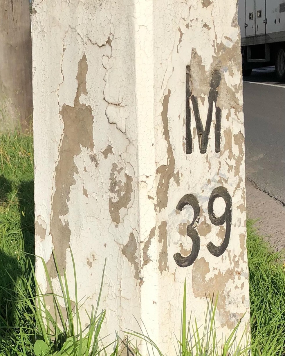
1920s · Argyle Street · Cultural Heritage · Engineering Heritage · Heritage · Highways · History · Hume Highway · Infrastructure · Living History · Local History · Local Studies · Memorial · Memorials · Memory · Mileposts · Monuments · Place making · Public art · Re-enactments · Service utilities · Storytelling · Technology · The Great South Road · Tourism · Transport · Travel · Utilities · Wayfinding

Capturing the distance of the past

Camden Mileposts

On the Camden Town Centre edges, there are two white concrete posts with numbers and letters. What are they, and what do the letters mean?

These white concrete posts are mileposts from when the Hume Highway ran up the centre of Camden along Argyle Street. The letters indicate destinations, and the numbers are distance in miles. These items are part of Camden’s engineering heritage.

A concrete milepost on the southern end of the Camden Town Centre on the road verge of the former Hume Highway now the Old Hume Highway. (I Willis, 2021)

The letters: M is Mittagong, S is Sydney, L is Liverpool and C is Camden. The distance is a mile:  an imperial unit of measure from before the time of metric measurement. The mile here is a statute mile which is 5280 feet or 1.609 km, as opposed to a nautical mile used in air and sea transport and is different.

The English mile

Mileposts dated back to the Roman Empire and were placed alongside the Roman roads. Distances were measured from the city of Rome. The mile originated from the Roman mille passus, or “thousand paces,” which measured 5,000 Roman feet.

The first mileposts along English roads appeared in 1593 and were standardised in England under the reign of Elizabeth I. The English mile was a different length from the Scottish mile and the Irish mile.  These measures were not standardised in the British Commonwealth and the US until 1959. (Sydney Morning Herald, 22 August 1935. https://www.britannica.com/science/mile)

In the colony of New South Wales, the first sandstone milestones were located on the Parramatta, Liverpool and South Head Roads from 1816 on the instructions of Governor Macquarie. Milestones provided accurate reference marks along with the expanding public road system for travellers on coaches. (Crofts and Crofts, 2013)

Macquarie Obelisk

In the colonial period, Governor Macquarie’s Obelisk of Distances was erected in 1818 as the official starting point for all distances in NSW. It was located in what was then the centre of Sydney and is now Macquarie Place. The monument was also ‘a symbolic peg’ as the furthest extent of the British Empire in the early 1800s.

Obelisk of Distances in Macquarie Place Sydney designed by Francis Greenway and built-in 1818 under the orders of Governor Macquarie c1926 (SLNSW)

The placement of milestones in colonial NSW set a precedent. They were placed along the left hand or southern side of the roadway with the destination facing Sydney. The posts were meant to be seen by travellers coming from either direction for the benefit of stagecoach drivers to measure their distance from Sydney. They also ensured that the driver was on the correct road as many were just bush tracks. (Crofts and Crofts, 2013)

Concrete mileposts

The two concrete mileposts in Camden were part of the road improvements by the NSW Department of Main Roads in 1934.

The decision to implement a programme of mileposting followed the first annual conference of state road authorities in February 1934 held in Melbourne. The meeting decided to adopt uniform national procedures for mileposting and road warning signs for roadworks, among other matters. It was felt that uniformity of services would help interstate travellers. (DMR, 1934)

A concrete milepost on the northern entry to the Camden Town Centre on the roadside verge of the former Hume Highway that ran along Argyle Street Camden. (I Willis, 2021)

In 1934 the department allocated £134 to the program in the Sydney area. (DMR, 1934)

The DMR Main Roads magazine stated that

In the days before the advent of the motor vehicle, when travel by road was slow and was done on foot, on horseback, or in horse-drawn carriage, few things gave greater service, or were more eagerly looked for, than the mileposts. (DMR, 1934a)

According to the Department of Main Roads, mileposting before 1934 provided signs that gave direction and the distance of important towns. Mileposts had lost their importance to the traveller because the car speedometer gave ‘progressive mileage’ stated a departmental report. (DMR, 1934a)

Road maintenance

Mileposting in 1934 was implemented with one specific aim.

The purpose of the mileposts now is to provide a convenient system of reference marks along the road for the use of those whose responsibility is to maintain the roads in a proper state. (DMR, 1934a)

The stated purpose was for the milepost to be a reference point along the road to give a precise position for any roadwork that needed to be done. Information to travellers was only secondary. (DMR, 1934a)

Mileposting to 1934 had been haphazard, with much work generated at a  local level and many gaps. Road maintenance was a secondary consideration, with information for travellers paramount. Much work was ‘incomplete’. Groups of mileposts were only based around important towns, sometimes following main roads and sometimes not. (DMR, 1934a)

The 1934 mileposting project was partly triggered by the 1928 classification of all roads in NSW into state highways, trunk roads and ordinary roads.

The 1928 changes saw The Great Southern Road through Camden renamed the Hume Highway in 1928. The 1929 Razorback Deviation shifted the highway to the east away from the former Great South Road (now Cawdor Road). (DMR, 1934a)

Different types of mileposts were used in 1934 for different purposes.  Concrete posts were used in the Sydney area and country towns, like Camden, and elsewhere there were timber posts.

Specifications and drawings for mileposts as outlined in the Department of Main Roads journal Main Roads (May 1934) where the DMR mileposting project was detailed for all roads in NSW (Main Roads 1934a)

There was a strict protocol for the letters and numbers on the posts, with letters and numbers incised and painted black and distances measured from the post office, and sometimes not.  Posts were placed on the left-hand side of roadways leading from Sydney or the coast, as they were in colonial times.

Posts were located with a clear view from the roadway of 200 feet with specific instruction on distances from roadways and locations for cuttings and embankments. On bridges, the mileposts were be clamped to the handrails.

In mid-1934, the NRMA suggested the mileposts on the different highways should be painted in a variety of colours. (Kiama Reporter and Illawarra Journal, 20 June 1934) The suggestion was not taken up.

One supplier of the concrete mileposts was the Hume Pipe Coy (Aust) Ltd. (Main Roads, August 1938)

Wooden Mileposts

In the Camden area, the Camden Heritage Inventory states there were wooden mileposts along Cawdor Road, formerly The Great South Road. They pre-date the concrete mileposts.

Timber milepost c1927 on the road verge of The Great South Road now Cawdor Road. (2021 I Willis)

In a 2002 survey for the Heritage Inventory, the three Cawdor Road timber mileposts were intact.

The posts were local hardwood cut by a sawmill in Edward Street in the late 1920s and delivered to The Great South Road (Cawdor Road) site by Camden teamster Les Nixon. (NSWSHI)

In a recent search, I was only able to locate one intact timber milepost in a fairly poor condition.

This timber milepost c.1929-1934 is located on the former Hume Highway at South Camden now Remembrance Drive. This milepost is located on the 1929 Hume Highway Razorback deviation that moved the main road from the Great South Road now Cawdor Road. (I Willis, 2021)

This timber milepost c.1929-1934 is located on the former Hume Highway at South Camden now Remembrance Drive. This milepost is not on the Wollondilly Shire Council heritage inventory. The milepost is sited on the roadside verge adjacent to the Camden Valley Inn. (I Willis, 2021)

References

CROFTS, R. & CROFTS, S. 2013. Discovering Australia’s Historical Milemarkers and Boundary Stones, Sydney, Roberts and Sandra Crofts.

DMR 1934. Department of Main Roads Ninth Annual Report for the year ending 30th June 1934. Sydney: NSW Legislative Assembly.

DMR 1934a. The Mileposting on Main Roads. Main Roads, 5.

Aesthetics · Architecture · Attachment to place · Belonging · British colonialism · Collective Memory · Colonialism · Community identity · Cultural Heritage · Cultural icon · England · Governor Macquarie · Highways · History · Living History · Local History · Local Studies · Memorialisation · Memorials · Memory · Mileposts · Monuments · Parks · Place making · Settler colonialism · Settler Society · Storytelling · Sydney · Urban development · Urban history · Wayfinding

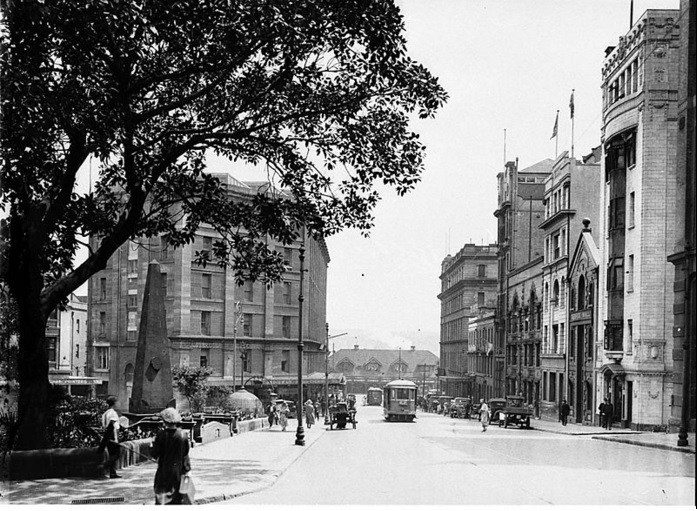
Macquarie Place: an overlooked city space of monumental importance

One of Sydney city’s hidden places is Macquarie Place, just off Bridge Street.  Tucked between Loftus Street and Pitt Street is a little bit of green. Rather dull, hidden from direct sunlight. A little bit tired, a little bit at heel amongst the skyscrapers and traffic congestion. A space in the city for today’s world of financial gurus, hotshots and lawyers.

Macq Place c1926 SLNSW
Macquarie Place with Obelisk c1926 (SLNSW)

Macquarie Place Park is a triangular-shaped space that has seen the city change around over 200 years. Once upon a time, it was an open space for the colonial elite in the elegant part of town next to the Governor’s House precinct, on the high ground above the Tanks Stream.

The New South Wales State Heritage Inventory states

 Macquarie Place was the first formally laid out public space in Sydney and thus in Australia. Governor Macquarie was responsible for its formal layout, befitting its important situation at the centre of the colony. The park and the memorials standing in this park outline the development of Sydney since its foundation.

On the harbour side of the park, The City of Sydney states that some of Sydney’s prominent early colonial businessmen held leases. They included  Simeon Lord, Thomas Randall, William Chapman, Andrew Thompson and Thomas and Mary Reibey.

The park was formalised when the sandstone obelisk designed by Francis Greenway was erected in 1818.  It was to mark Sydney’s first public square and the place from which all roads in New South Wales were to be measured.

The construction of Circular Quay between 1839 and 1847 saw an extension of several streets and took up a portion of the park. The reserve was enlarged in the 1970s when Macquarie Place (street) was closed and incorporated into the park.

Over the years, its position at the centre of its world changed. Government House was moved up to Macquarie Street. By the end of the Victorian period, Macquarie Place was surrounded by government administration and commercial offices of shipping merchants and agents.

In the eyes of many, the fate of Macquarie Place is representative of the changing faces of the city, from a working maritime harbour to part of the 24/7 global financial network which never turns off. The wheeling and dealing of today’s financial houses are reminiscent of the 17th and 18th centuries, which shaped the future of imperial London and the British Empire and appeared around the park in the late 19th century.

Macquarie Place has always had a global feel from those who passed through in the past in the Victorian and early colonial period and the international financial hotshots and hipsters of the present. It has been a transient place for those who occupied it, and the current batch of latte-sipping dealmakers is no different. The space is a site of both continuity and change.

The space was filled with monuments to the commercial pioneers (Mort), relics from the seafaring age (Sirius anchor), and the symbols of the power of colonial administrators. Macquarie Place monuments represent the changing period of the usage of the city and the world.

In 1907 the anchor and cannon from the HMS Sirius (1780-1790) were placed in Macquarie Place. HMS Sirius was one of the naval escorts of the First Fleet in 1788. The anchor was brought to Sydney after HMS Sirius was wrecked at Norfolk Island in 1790. The HMS Sirius was built in 1780-1781 as an Eastern Indian trader and named Berwick of 510 tons. It was purchased by the British Admiralty as a store ship in 1781 and renamed HMS Sirius in 1786. It was armed with 10 canons, carried 160 men and could do 10 knots with a strong wind.

There is the bronze statue of Thomas Sutcliffe Mort. The dedication on the  plinth:

 A pioneer of Australian resources, a founder of Australian industries, one who established our wool market.

Mort (1816-1878) arrived in Sydney in 1838 with his parents. He was a successful and flamboyant Sydney businessman, auctioneer, mine owner, pastoralist, manufacturer, horticulturalists and churchman. He lived at Darling Point, where he was a keen gardener.

Unveiling Thomas Mort Statue 1887 (Wikimedia)

There is also the 1908 domed toilet building with Edwardian Art Nouveau ironwork and an 1857 cast iron drinking fountain.

The beginning of the Remembrance Driveway from Sydney to Canberra is marked by two plane trees planted by Her Majesty Queen Elizabeth II in 1954.

The New South Wales State Heritage Inventory states:

Macquarie Place is now the oldest town square in Australia. Together with Hyde Park, it is also the oldest urban park in Australia and has been in continuous operation as a public space for at least 195 years.

The park provides a breath of fresh air between the city towers that now enclose it. Today Macquarie Place is a world of cafes frequented by Sydney’s financial gurus who determine the future of Australia. The Victorian edifices to colonial administration are silent, awaiting the wishes of the latest rent-seeking developers.

Read more about Macquarie Place

  1. City of Sydney

2. NSW State Heritage Inventory

3. Anne Marie Whitaker, ‘Macquarie Place’, Dictionary of Sydney

Updated on 4 May 2023. Originally posted on 16 February 2018.