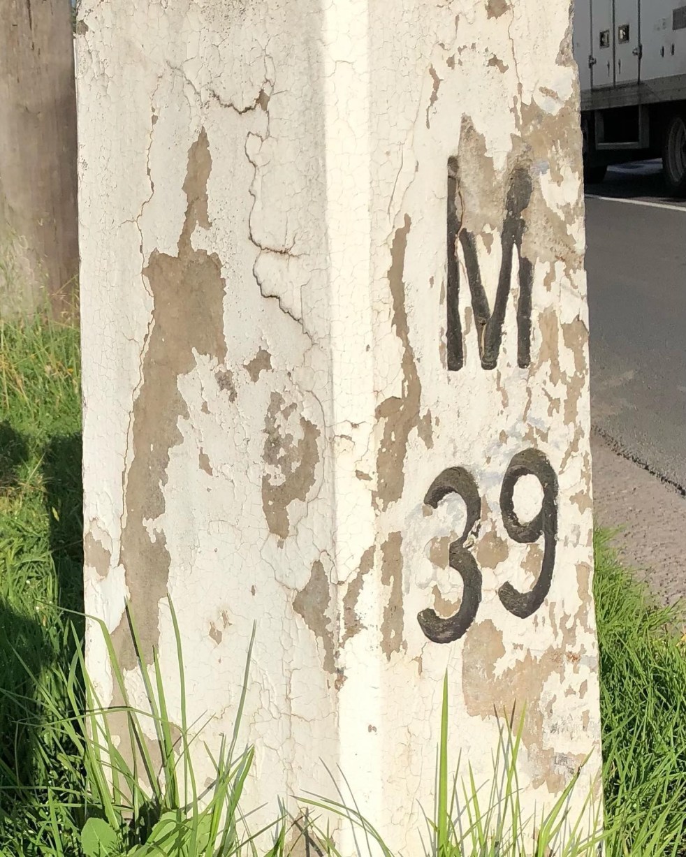
1920s · Argyle Street · Cultural Heritage · Engineering Heritage · Heritage · Highways · History · Hume Highway · Infrastructure · Living History · Local History · Local Studies · Memorial · Memorials · Memory · Mileposts · Monuments · Place making · Public art · Re-enactments · Service utilities · Storytelling · Technology · The Great South Road · Tourism · Transport · Travel · Utilities · Wayfinding

Capturing the distance of the past

Camden Mileposts

On the Camden Town Centre edges, there are two white concrete posts with numbers and letters. What are they, and what do the letters mean?

These white concrete posts are mileposts from when the Hume Highway ran up the centre of Camden along Argyle Street. The letters indicate destinations, and the numbers are distance in miles. These items are part of Camden’s engineering heritage.

A concrete milepost on the southern end of the Camden Town Centre on the road verge of the former Hume Highway now the Old Hume Highway. (I Willis, 2021)

The letters: M is Mittagong, S is Sydney, L is Liverpool and C is Camden. The distance is a mile:  an imperial unit of measure from before the time of metric measurement. The mile here is a statute mile which is 5280 feet or 1.609 km, as opposed to a nautical mile used in air and sea transport and is different.

The English mile

Mileposts dated back to the Roman Empire and were placed alongside the Roman roads. Distances were measured from the city of Rome. The mile originated from the Roman mille passus, or “thousand paces,” which measured 5,000 Roman feet.

The first mileposts along English roads appeared in 1593 and were standardised in England under the reign of Elizabeth I. The English mile was a different length from the Scottish mile and the Irish mile.  These measures were not standardised in the British Commonwealth and the US until 1959. (Sydney Morning Herald, 22 August 1935. https://www.britannica.com/science/mile)

In the colony of New South Wales, the first sandstone milestones were located on the Parramatta, Liverpool and South Head Roads from 1816 on the instructions of Governor Macquarie. Milestones provided accurate reference marks along with the expanding public road system for travellers on coaches. (Crofts and Crofts, 2013)

Macquarie Obelisk

In the colonial period, Governor Macquarie’s Obelisk of Distances was erected in 1818 as the official starting point for all distances in NSW. It was located in what was then the centre of Sydney and is now Macquarie Place. The monument was also ‘a symbolic peg’ as the furthest extent of the British Empire in the early 1800s.

Obelisk of Distances in Macquarie Place Sydney designed by Francis Greenway and built-in 1818 under the orders of Governor Macquarie c1926 (SLNSW)

The placement of milestones in colonial NSW set a precedent. They were placed along the left hand or southern side of the roadway with the destination facing Sydney. The posts were meant to be seen by travellers coming from either direction for the benefit of stagecoach drivers to measure their distance from Sydney. They also ensured that the driver was on the correct road as many were just bush tracks. (Crofts and Crofts, 2013)

Concrete mileposts

The two concrete mileposts in Camden were part of the road improvements by the NSW Department of Main Roads in 1934.

The decision to implement a programme of mileposting followed the first annual conference of state road authorities in February 1934 held in Melbourne. The meeting decided to adopt uniform national procedures for mileposting and road warning signs for roadworks, among other matters. It was felt that uniformity of services would help interstate travellers. (DMR, 1934)

A concrete milepost on the northern entry to the Camden Town Centre on the roadside verge of the former Hume Highway that ran along Argyle Street Camden. (I Willis, 2021)

In 1934 the department allocated £134 to the program in the Sydney area. (DMR, 1934)

The DMR Main Roads magazine stated that

In the days before the advent of the motor vehicle, when travel by road was slow and was done on foot, on horseback, or in horse-drawn carriage, few things gave greater service, or were more eagerly looked for, than the mileposts. (DMR, 1934a)

According to the Department of Main Roads, mileposting before 1934 provided signs that gave direction and the distance of important towns. Mileposts had lost their importance to the traveller because the car speedometer gave ‘progressive mileage’ stated a departmental report. (DMR, 1934a)

Road maintenance

Mileposting in 1934 was implemented with one specific aim.

The purpose of the mileposts now is to provide a convenient system of reference marks along the road for the use of those whose responsibility is to maintain the roads in a proper state. (DMR, 1934a)

The stated purpose was for the milepost to be a reference point along the road to give a precise position for any roadwork that needed to be done. Information to travellers was only secondary. (DMR, 1934a)

Mileposting to 1934 had been haphazard, with much work generated at a  local level and many gaps. Road maintenance was a secondary consideration, with information for travellers paramount. Much work was ‘incomplete’. Groups of mileposts were only based around important towns, sometimes following main roads and sometimes not. (DMR, 1934a)

The 1934 mileposting project was partly triggered by the 1928 classification of all roads in NSW into state highways, trunk roads and ordinary roads.

The 1928 changes saw The Great Southern Road through Camden renamed the Hume Highway in 1928. The 1929 Razorback Deviation shifted the highway to the east away from the former Great South Road (now Cawdor Road). (DMR, 1934a)

Different types of mileposts were used in 1934 for different purposes.  Concrete posts were used in the Sydney area and country towns, like Camden, and elsewhere there were timber posts.

Specifications and drawings for mileposts as outlined in the Department of Main Roads journal Main Roads (May 1934) where the DMR mileposting project was detailed for all roads in NSW (Main Roads 1934a)

There was a strict protocol for the letters and numbers on the posts, with letters and numbers incised and painted black and distances measured from the post office, and sometimes not.  Posts were placed on the left-hand side of roadways leading from Sydney or the coast, as they were in colonial times.

Posts were located with a clear view from the roadway of 200 feet with specific instruction on distances from roadways and locations for cuttings and embankments. On bridges, the mileposts were be clamped to the handrails.

In mid-1934, the NRMA suggested the mileposts on the different highways should be painted in a variety of colours. (Kiama Reporter and Illawarra Journal, 20 June 1934) The suggestion was not taken up.

One supplier of the concrete mileposts was the Hume Pipe Coy (Aust) Ltd. (Main Roads, August 1938)

Wooden Mileposts

In the Camden area, the Camden Heritage Inventory states there were wooden mileposts along Cawdor Road, formerly The Great South Road. They pre-date the concrete mileposts.

Timber milepost c1927 on the road verge of The Great South Road now Cawdor Road. (2021 I Willis)

In a 2002 survey for the Heritage Inventory, the three Cawdor Road timber mileposts were intact.

The posts were local hardwood cut by a sawmill in Edward Street in the late 1920s and delivered to The Great South Road (Cawdor Road) site by Camden teamster Les Nixon. (NSWSHI)

In a recent search, I was only able to locate one intact timber milepost in a fairly poor condition.

This timber milepost c.1929-1934 is located on the former Hume Highway at South Camden now Remembrance Drive. This milepost is located on the 1929 Hume Highway Razorback deviation that moved the main road from the Great South Road now Cawdor Road. (I Willis, 2021)

This timber milepost c.1929-1934 is located on the former Hume Highway at South Camden now Remembrance Drive. This milepost is not on the Wollondilly Shire Council heritage inventory. The milepost is sited on the roadside verge adjacent to the Camden Valley Inn. (I Willis, 2021)

References

CROFTS, R. & CROFTS, S. 2013. Discovering Australia’s Historical Milemarkers and Boundary Stones, Sydney, Roberts and Sandra Crofts.

DMR 1934. Department of Main Roads Ninth Annual Report for the year ending 30th June 1934. Sydney: NSW Legislative Assembly.

DMR 1934a. The Mileposting on Main Roads. Main Roads, 5.

Adaptive Re-use · Aesthetics · Architecture · Argyle Street · Attachment to place · Business · Camden · Camden Gasworks · Camden Story · Communications · Community identity · Cultural Heritage · Cultural icon · Electricity · Engineering Heritage · Gas · Gothic · Heritage · Historical Research · Historical thinking · History · Industrial Heritage · Infrastructure · Living History · Local History · Local Studies · Memory · Myths · Place making · Public art · Sense of place · Service utilities · Storytelling · Streetscapes · Technology · Town planning · Urban Planning · urban sprawl · Urbanism · Utilities · Water

Mundane objects tell an interesting story

Utility pit covers

What is under your feet and totally ignored? What do you walk over every day? What is essential in an emergency? What provides access to critical utilities? The answer lies under our feet. What is it? Give up yet?

The answer is the humble utility inspection cover.

Gas Cover Durham Argyle Street Camden 2016 (I Willis)

Utilities like electricity, water, gas, sewerage, communications and others are essential in any community. Camden has acquired the utilities as time has progressed over the past 150 years to the present. Argyle Street has several utilities buried beneath the street and footpaths. Their histories provide valuable insight into the town’s development and progress, particularly in the 20th century.

The arrival of electricity, gas, and water was part of Camden modernism and its influence. These utilities have transnational origins beyond the township and illustrate the linkages between the town and the wider world.

For example, the supply of clean drinking water in Camden was linked to an outbreak of scarlet fever in the later 19th century. Contagious diseases were a significant health concern in the 19th century and were an ever-present worry in daily life. Clean drinking water had a significant influence on the development of public health.

I was walking along Camden’s Argyle Street, and it struck me that utility inspection covers are a historical statement in their own right. They are an entry point for the utility service as they also provide an entry to the stories surrounding the utility’s delivery.

Even the different logos for utilities illustrate the changes in the history of a telco or electricity supplier. A cover might be a statement about a utility supplier that is now defunct. The utility cover is made of different materials – cast iron, concrete, and others.

These are all mysteries that are waiting to be solved for the curious mind. Or just for the bored and idle with nothing better to do.

What about the Gas Cover from Durham above?

Durham Gas Cover

This is an inspection cover for the gas pipes using a Durham fitting probably around 1912. The Durham drainage fitting is a cast-iron, threaded fitting used on drainage pipes; has a shoulder such as to present a smooth, continuous interior surface. (Free Dictionary)  The Durham patent system of screw-joint iron house drainage was manufactured by the Durham House Drainage Co. of York USA (1887).

The Durham cover is for the Camden gas supply, installed in 1912 by the Camden Gas Company. The gasworks was built in Mitchell Street and made gas from coal. There were many gas street lights in Argyle Street which were turned on in early 1912. The Camden News reported in January 1912 that many private homes and businesses had been connected to the gas supply network and were fitted for gaslighting.

Mr Murray, the gasworks manager, reported that construction at the gasworks had been completed, the retort had been lit, and he anticipated total supply by the end of the month. (Camden News, 4 January 1912) Throughout 1912 there was an ongoing dispute between Mr Alexander, the managing director of the Camden Gas Company, and Camden Municipal Council over damage to Argyle Street while laying gas pipes and who was going to pay for it. (Camden News, 12 September 1912)

In 1946 Camden Municipal Council purchased the Camden Gas Company. The gasworks was sold to AGL in 1970. (Peter Mylrea, ‘Gas and Electricity in Camden’, Camden History March 2008.)

NRCC

What is this cover for the NRCC? Does it still exist?

NRCC Inspection Cover 2016 Argyle St Camden (I Willis)


The NRCC does not exist anymore, and the logo stood for the Nepean River County Council. It was the electricity supplier for the Campbelltown, Camden and Picton area from 1954 to 1979 when it was amalgamated with Prospect County Council. This, in turn, became Integral Energy. Integral Energy was formed by the New South Wales Government in 1995 from the amalgamation of Illawarra Electricity and Prospect Electricity with over 807,000 customers.

NRCC office open 1956 Picton SLNSW

The Campbelltown office of the NRCC was located in Queen Street next to the Commonwealth Bank and in 1960 shifted to Cordeaux Street. By 1986 a new advisory office was opened in Lithgow Street. The council opened a new shop front at Glenquarie Shopping Centre at Macquarie Fields. There were shopfronts in Camden, Picton and other locations.

Logo Design

In  October 1954, the NRCC approved a design for its official seal. Alderman P Brown suggested a logo competition, and many entries were received for the £25 prize. The winning design by artist Leone Rush of Lidcombe depicts electricity being extended to rural areas by a circular outline of “Nepean River County Council”.
(Camden News, Thursday 4 November 1954.)

NRCC Seal (http://www.nepeanrivercountycouncil.com.au/)
Nepean River County Council Seal (http://www.nepeanrivercountycouncil.com.au/)

Former NRCC employee Sharon Greene stated that ‘It was like a small family business where everyone was happy to be there.’ (Camden Advertiser, 25 May 2009)

Former office manager, Kay Kyle, said that things in the office in 1959 were pretty bare when she started as a junior clerk.

She said:

‘We had no cash registers or adding machines, we hand wrote receipts and added the figures in our head for daily takings. That was a good skill to have. Eventually we received an old adding machine from Picton, but one day it added incorrectly so I wouldn’t use it again.’  (http://www.nepeanrivercountycouncil.com.au/nrccstories.html)

Former linesman Joe Hanger recalls working for the NRCC. He said,

‘In 1954 we were transferred to Nepean River County Council. They wanted linesmen and I went on the line crew and eventually worked my way up and got a pole inspectors job going around creosoting the poles. Eventually I got my own crew, mainly pole dressing. There were 7-8 in the crew. I was then made a foreman in about 1978.’ (http://www.nepeanrivercountycouncil.com.au/nrccstories.html)

Working in the outdoor crews could be dangerous, as Joe Hanger remembers.

‘In July 1974 I fell from a 40ft pole while doing work near The Oaks. We had to check out why a back feed to The Oaks was loosing voltage. We were looking for crook joints. The pole is still out there, near a bend just before the straight road into The Oaks. We had opened the air break switch behind us and the airbreak switch ahead, we forgot that the transformer was on the other side of the open point. I checked the pole and Neville Brown had gone along to the next pole to open the next section. I was standing on the low voltage cross arm and grabbed one of the wires and was struck by the electricity. Luckily my weight caused me to fall away. I ended up falling about 25 feet and just another pole lying on the ground. If I had the belt on it may have been a different matter. I had a broken leg, broken rib and a great big black eye. I was very lucky.’

(http://www.nepeanrivercountycouncil.com.au/nrccstories.html)

There are a host of other stories and wonderful memories from former employees of NRCC @ http://www.nepeanrivercountycouncil.com.au/nrccstories.html.

Friends of the Nepean River Country Council

Past organisations like the Nepean River County Council have staunch supporters. If you are one of them, join the Friends of NRCC. 

Friends of NRCC

The telco inspection lid

This inspection lid is for the telco, which was the Postmaster-General Department of the Australian Government.

PMG Inspection Cover 2016 Argyle St Camden (I Willis)

The telco had a rich history of communications in Australia, starting in 1810 with the first postal service. In 1810 Governor Macquarie appointed Australia’s first postmaster Isaac Nicholls and the colonial government of New South Wales Government the first regular postal services, including rates of postage. The new Sydney General Post Office was opened in George Street in 1874.

The first telephone service was established in Melbourne in 1879.

At Federation, the new Commonwealth Postmaster-General’s Department assumed responsibility for telephone, telegraph and postal services. In the 1920s, the department took control of international short wave services and the Australian Broadcast Commission in the 1930s.

In 1975 the Postmaster-General Department was broken up, and the postal service moved to Australia Postal Commission (trading at Australia Post). Telecommunications became the responsibility of the Australian Telecommunications Commission trading at Telecom Australia. Telecom Australia was corporatised in 1989, renamed Telstra Australia in 1993, and partially privatised in 1999.

In 1992 the Overseas Telecommunications Commission (est 1946) was merged with Telecom Australia.

Telstra Inspection Cover 2016 Argyle St Camden
Inspect Cover Telecom
Telecom Inspection Cover 2016 Argyle St Camden (I Willis)

 MWS&DB

Service Valve cover for water MWS&DB Argyle St Camden 2016 (I Willis)

The MWS&DB was the Metropolitan Water Sewerage and Drainage Board, today is known as Sydney Water. The organisation has gone through several name changes:

  • the Board of Water Supply and Sewerage from 1888 to 1892,
  • from 1892 to 1925 as the Metropolitan Board of Water Supply and Sewerage,
  • the MWS&BD from 1925 to 1987,
  • then the Water Board from1987 to1994, then finally as the
  • Sydney Water Corp Ltd (1995-1999) with Ltd dropped in 1999.

Deks G (Gas)

Deks Cover for gas in Argyle Street Camden 2016 (I Willis)

Deks was established in Australia by Mr George Cupit in 1947 and remained a family business until it became part of the Skellerup Group in 2003. Deks have a presence in 28 countries. They have supplied plumbing fittings, including flashings, fittings or flanges, for over 100 years. (http://www.deks.com.au/about/)

Malco W (Water)

Malco Cover for Water Argyle Street Camden 2016 (I Willis)

Malco Industries reported in the Sydney Morning Herald in 1951 that the company incorporated three separate businesses involved in heavy industrial activities on its site at Marrickville. There were three divisions (1) Malleable Castings was founded in 1915 and was claimed to be one of Australia’s leading producers of iron castings. (2) EW Fittings was incorporated in 1925 and made cast iron pipe fittings for water, gas, steam and oil. (3) Link-Belt Co Pty set up in 1949 and industrial transmission equipment. (Sydney Morning Herald (NSW: 1842 – 1954), Friday 6 April 1951, page 6)

Romwood SV

Service Valve Romwood Argyle Street Camden 2016 (I Willis)

Havestock Cover

Havestock Cover Argyle Street Camden 2016 (I Willis)

Havestock is a business that has made pit lids since the 1980s. Havestock is now part of the global EJ Group and designs, manufactures and distributes man-hole covers, pit covers and other infrastructure access covers and grates. (http://www.hygrade.net.nz/product-category/by-brand/by-brand-havestock/) (http://www.homeimprovementpages.com.au/connect/havestock_pty_ltd/)

Updated 26 October 2021. Originally posted 21 October 2016.