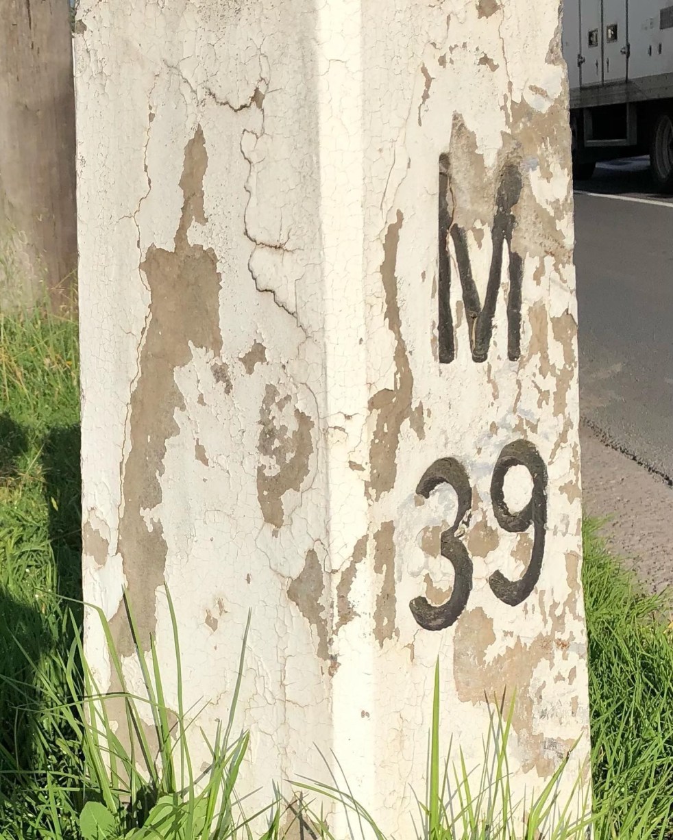
1920s · Argyle Street · Artefacts · Attachment to place · Camden · Camden Story · Collective Memory · Cultural Heritage · Engineering Heritage · Engineering History · Heritage · Highways · History · Hume Highway · Infrastructure · Living History · Local History · Local Studies · Memorial · Memorials · Memory · Mileposts · Monuments · Place making · Public art · Re-enactments · Roads · Service utilities · Storytelling · Technology · The Great South Road · Tourism · Transport · transport history · Travel · Travellers · Utilities · Wayfinding

Mileposts captured the distance of the past

Camden Mileposts

On the Camden Town Centre edges are two white concrete posts with numbers and letters. What are they, and what do the letters mean?

These white concrete posts are mileposts from when the Hume Highway ran up the centre of Camden along Argyle Street. The letters indicate destinations and the numbers are distance in miles. These items are part of Camden’s engineering heritage.

A concrete milepost on the southern end of the Camden Town Centre on the road verge of the former Hume Highway, now the Old Hume Highway. (I Willis, 2021)

The letters: M is Mittagong, S is Sydney, L is Liverpool, and C is Camden. The distance is a mile:  an imperial unit of measure from before the time of metric measurement. The mile here is a statute mile which is 5280 feet or 1.609 km, as opposed to a nautical mile used in air and sea transport and is different.

The English mile

Mileposts dated back to the Roman Empire and were placed alongside the Roman roads. Distances were measured from the city of Rome. The mile originated from the Roman mille passus, or “thousand paces,” which measured 5,000 Roman feet.

The first mileposts along English roads appeared in 1593 and were standardised in England under the reign of Elizabeth I. The English mile was a different length from the Scottish mile and the Irish mile.  These measures were not standardised in the British Commonwealth and the US until 1959. (Sydney Morning Herald, 22 August 1935. https://www.britannica.com/science/mile)

In the colony of New South Wales, the first sandstone milestones were located on the Parramatta, Liverpool and South Head Roads from 1816 on the instructions of Governor Macquarie. Milestones provided accurate reference marks along with the expanding public road system for travellers on coaches. (Crofts and Crofts, 2013)

Macquarie Obelisk

In the colonial period, Governor Macquarie’s Obelisk of Distances was erected in 1818 as the official starting point for all distances in NSW. It was located in what was then the centre of Sydney and is now Macquarie Place. The monument was also ‘a symbolic peg’ as the furthest extent of the British Empire in the early 1800s.

Obelisk of Distances in Macquarie Place Sydney was designed by Francis Greenway and built-in 1818 under the orders of Governor Macquarie c1926 (SLNSW)

The placement of milestones in colonial NSW set a precedent. They were placed along the left-hand or southern side of the roadway, with the destination facing Sydney. The posts were meant to be seen by travellers coming from either direction to measure their distance from Sydney for the benefit of stagecoach drivers. They also ensured the driver was on the correct road, as many were bush tracks. (Crofts and Crofts, 2013)

Concrete mileposts

The two concrete mileposts in Camden were part of the road improvements by the NSW Department of Main Roads in 1934.

The decision to implement a programme of mileposting followed the first annual conference of state road authorities in February 1934 held in Melbourne. The meeting decided to adopt uniform national procedures for mileposting and road warning signs for roadworks, among other matters. It was felt that uniformity of services would help interstate travellers. (DMR, 1934)

A concrete milepost on the northern entry to the Camden Town Centre on the roadside verge of the former Hume Highway ran along Argyle Street Camden. (I Willis, 2021)

In 1934 the department allocated £134 to the program in the Sydney area. (DMR, 1934)

The DMR Main Roads magazine stated that

According to the Department of Main Roads, mileposting before 1934 provided signs that gave directions and the distance of important towns. Mileposts had lost their importance to the traveller because the car speedometer gave ‘progressive mileage’ stated a departmental report. (DMR, 1934a)

Road maintenance

Mileposting in 1934 was implemented with one specific aim.

The stated purpose was for the milepost to be a reference point along the road to give a precise position for any roadwork needed. Information to travellers was only secondary. (DMR, 1934a)

Mileposting to 1934 had been haphazard, with much work generated at a  local level and many gaps. Road maintenance was a secondary consideration, with information for travellers paramount. Much work was ‘incomplete’. Groups of mileposts were only based around important towns, sometimes following main roads and sometimes not. (DMR, 1934a)

The 1934 mileposting project was partly triggered by the 1928 classification of all roads in NSW into state highways, trunk roads and ordinary roads.

The 1928 changes saw The Great Southern Road through Camden renamed the Hume Highway in 1928. The 1929 Razorback Deviation shifted the highway to the east, away from the former Great South Road (now Cawdor Road). (DMR, 1934a)

Different types of mileposts were used in 1934 for different purposes.  Concrete posts were used in Sydney and country towns like Camden, and timber posts were used elsewhere.

Specifications and drawings for mileposts as outlined in the Department of Main Roads journal Main Roads (May 1934), where the DMR mileposting project was detailed for all roads in NSW (Main Roads 1934a)

There was a strict protocol for the letters and numbers on the posts, with letters and numbers incised and painted black and distances measured from the post office, sometimes not.  Posts were placed on the left-hand side of roadways leading from Sydney or the coast, as they were in colonial times.

Posts were located with a clear view from the roadway of 200 feet with specific instructions on distances from roadways and locations for cuttings and embankments. On bridges, the mileposts were clamped to the handrails.

In mid-1934, the NRMA suggested the mileposts on the different highways should be painted in various colours. (Kiama Reporter and Illawarra Journal, 20 June 1934) The suggestion was not taken up.

One supplier of the concrete mileposts was the Hume Pipe Coy (Aust) Ltd. (Main Roads, August 1938)

Wooden Mileposts

In the Camden area, the Camden Heritage Inventory states there were wooden mileposts along Cawdor Road, formerly The Great South Road. They pre-date the concrete mileposts.

Timber milepost c1927 on the verge of The Great South Road, now Cawdor Road. (2021 I Willis)

In a 2002 survey for the Heritage Inventory, the three Cawdor Road timber mileposts were intact.

The posts were local hardwood cut by a sawmill in Edward Street in the late 1920s and delivered to The Great South Road (Cawdor Road) site by Camden teamster Les Nixon. (NSWSHI)

In a recent search, I could only locate one intact timber milepost in fairly poor condition.

This timber milepost c.1929-1934 is located on the former Hume Highway at South Camden, now Remembrance Drive. This milepost is located on the 1929 Hume Highway Razorback deviation that moved the main road from the Great South Road, now Cawdor Road. (I Willis, 2021)

This timber milepost c.1929-1934 is located on the former Hume Highway at South Camden, now Remembrance Drive. This milepost is not on the Wollondilly Shire Council heritage inventory. The milepost is on the roadside verge adjacent to the Camden Valley Inn. (I Willis, 2021)

References

CROFTS, R. & CROFTS, S. 2013. Discovering Australia’s Historical Milemarkers and Boundary Stones, Sydney, Roberts and Sandra Crofts.

DMR 1934. Department of Main Roads Ninth Annual Report for the year ending 30th June 1934. Sydney: NSW Legislative Assembly.

DMR 1934a. The Mileposting on Main Roads. Main Roads, 5.

Updated on 15 August 2023. Originally posted on 13 November 2021 as ‘Capturing the distance of the past’.

Agriculture · Art · Attachment to place · Belonging · Camden Story · Colonialism · Cowpastures · Cultural Heritage · Cultural icon · History · Landscape · Local History · Memorial · Memorials · Monuments · Oran Park · Parks · Place making · Placemaking · Public art · Settler colonialism · Settler Society · Storytelling · Tourism

Cowpastures memorial, Oran Park

A celebration of a landscape of cows at Oran Park

As you wander around the administration-library-shopping precinct at Oran Park, there is a sense of anticipation that you are being watched. If you look around, several bronze bovine statues are guarding the site. They are a representation of the Cowpastures Wild Cattle of the 1790s.

The bronze herd of horned cattle consists of six adult beasts and one calf wandering in a line across the manicured parkland landscape. The bovine art connoisseur can engage with the animals and walk among them to immerse themselves in a recreated moment from the past – a form of living history.

The Cowpastures public art installation at Perich Park in Central Avenue at Oran Park (I Willis, 2017)

The bronze cattle dramatically contrasts with the striking contemporary architecture of the council building across the road. Opening in 2016, the cantilevered glass-boxed and concrete Camden Council administration building was designed by Sydney architects GroupGSA.

This bovine-style art installation is the second memorial to the Cowpastures, the fourth location of European settlement in the New South Wales colony. The artwork is found in Perich Park, named after the family that endowed the community with the open space.

The herd of bronze cows in Perich Park in Central Avenue at Oran Park (I Willis, 2017)

The story of the Cowpastures is told on the storyboard located adjacent to the artwork.  It states:

The Wild Cattle of the Cowpastures

There are several versions of this story. There seems to be a consensus that two bulls (one bull calf) and five cows were purchased at the Cape of Good Hope and landed at Sydney Cove with the First Fleet in January 1788. The cattle were black and the mature bull was of the Afikander [sic – Afrikander] breed.

Shortly after the arrival of the First Fleet the two bulls and five cows could not be found and it was not until seven years later in 1795 that a convict reported sighting a herd of cattle in the bush.

Governor Hunter dispatched Henry Hacking to report on the cattle. Hunter resolved to inspect them himself and in November 1795 with a party of mainly Naval officers he found a herd of sixty-one cattle near the Nepean River near what is now known as Menangle.

Governor Hunter named the area The Cowpastures Plains. He wrote ‘They have chosen a beautiful part of the country to graze in…and they may become…a very great advantage resource to this Colony’. They were rather wild and inferior but bred rapidly.

By 1801 the herd had increased naturally to an estimated five or six hundred head. In 1811 they were estimated to be in their thousands.

The bronze cattle here have been kindly donated to the Community by the Perich Family.

Information board for Cowpasture art installation at Perich Park in Central Avenue at Oran Park (I Willis, 2017)

The bronzed-bovines in Perich Park on Central Ave were installed in 2016 to coincide with the opening of the new council building.

The Perich Park art installation is preceded by an earlier artwork that depicted more bovines just up the street. The other animal sculptures were a set of concrete cows that were represented wandering around in a small reserve opposite the Oran Park development sales office in Peter Brock Drive.

The reserve is located between Peter Brock Drive and Moffat Street, and this batch-of-bovines were installed around 2010. The reserve and open space is not designated parkland, and signage indicates that it is destined for housing development.

A concrete cow in the reserve in Moffat Street Oran Park (I Willis, 2010)

A concrete cow in the reserve in Moffat Street at Oran Park (I Willis, 2010)

Placemaking

The use of public art is one approach to placemaking that is employed by urban planners and designers, architects, and others. The authorities responsible for creating the Oran Park community and the new suburbs within it have used public art for placemaking.

What is placemaking?

Placemaking is a multi-faceted approach to the planning, design and management of public spaces. Placemaking capitalizes on a local community’s assets, inspiration, and potential, with the intention of creating public spaces that promote people’s health, happiness, and well-being. 

In the United States, the National Endowment for the Arts states that creative placemaking.

integrates arts, culture, and design activities into efforts that strengthen communities. Creative placemaking requires partnership across sectors, deeply engages the community, involves artists, designers and culture bearers, and helps to advance local economic, physical, and/or social change, ultimately laying the groundwork for systems change.

Storytelling promotes the concept of place and the process of placemaking. One of those stories is the Cowpastures and the Wild Cattle history from the days of colonial New South Wales.

Understanding the past through storytelling contributes to the construction of community identity and builds resilience in new communities. The cultural heritage of an area is the traditions, ceremonies, stories, events and personalities of a place. There are also dark and hidden stories of the Cowpastures that need telling, such as the frontier violence of the Appin Massacre.

The Cowpasture art installation uses a living history approach to tell the story of the European occupation of the local area that is part of the history of colonialism and the settler society project in New South Wales.

Aesthetics · Art · Attachment to place · Colonial frontier · Colonialism · Cowpastures · Cultural Heritage · Dharawal · Farming · Frontier violence · Harrington Park · Heritage · History · Landscape · Living History · Local History · Macarthur · Memorial · Memory · Monuments · Place making · Placemaking · Sense of place · Storytelling · Urban development · Urban growth · Wayfinding

Cowpastures: artwork at Harrington Park Lake

Public art as wayfinding, placemaking, memorial and urban development

The story of the Cowpastures is represented in public art across the Macarthur region; one example is found along the Harrington Park Lake walkway.

 A pleasant stroll around the lakeside path will bring the walker to a wooded section where there is an art installation with cows hiding under the trees.

The public artwork is a mixture of elements that combine wayfinding, placemaking, memorialisation and urban development in a new suburb.

The artwork installation called Cowpastures was created by artist Jane Cavanough of Artlandish Art and Design in 2001. The signage states ‘The cows represent the history of cattle grazing in this region, formerly known as “The Cowpastures”.

Artist Jane Cavanough

Artist Jane Cavanough writes that she ‘produces site-specific public art that combines a classic and contemporary design, interactive, low maintenance with long-lasting beauty. She states that her ‘strength is creating artworks that have a strong relationship to the site’. (Cavanough 2020)

Cavanough has achieved her aim with Cowpastures on the Lakeside Walk, where walkers can engage with the artwork and ponder what the real cows might have looked like over 200 years ago. The artwork has weathered well over the last 20 years and still carries the story created by the artist.

Jane Cavanough’s Cowpastures public art installation on the Harrington Park Lakeside walkway (I Willis, 2021)

<cows pic>

Public art.

The considerations in Cavanough’s Cowpastures parallel the aims of public art in the Northern Beaches LGA. Important considerations for the community and the council along the Northern Beaches Coast Walk were eight principles:

  • Respect and acknowledge the Aboriginal cultural heritage
  • Celebrate and conserve significant natural and cultural values
  • Connect places and people along the coast.
  • Foster artistic and cultural expression and encourage creative collaboration
  • Enrich places through high-quality art and design.
  • Interpret the history and significance of the coast
  • Value artistic and cultural diversity and be inclusive
  • Create a distinctive and recognisable Northern Beaches Coast Walk identity.(Council 2019)

It is helpful in actually defining what is public art. The Northern Beaches Council Public Art Policy provides some guidance and states:

Public Art refers to a range of artwork and art-based activities that interface with the public, including private ownership property with publicly accessible space and the public domain. Public Art can include sculpture, place-making elements, wall embellishments, art integrated into the design of buildings, artist-designed seating and fencing, paving work, lighting elements and other creative possibilities. Public Art can serve both an aesthetic and functional purpose.

The public domain means public places and/or open spaces that are situated within, vested in or managed by Council, including parks, beaches, bushland, outdoor recreation facilities, streets, laneways, pathways and foreshore promenades and public buildings, facilities or enclosed structures, owned and managed by Council which are physically accessible to the general public. (Council 2019)

Camden Council defines public art as:

Defined as any artistic work or activity designed and created by professional arts practitioners for the public domain, Public Art may be of a temporary or permanent nature and located in or part of a public open space, building or facility, including façade elements provided by either the public or private sector (not including memorials or plaques).

Public art can….

  • make art an everyday experience for residents and visitors
  • take many forms in many different materials and styles, such as lighting, sculpture, performance and artwork
  • be free-standing work or integrated into the fabric of buildings, streetscapes and outdoor spaces
  • draw its meaning from or add to the meaning of a particular site or place
Jane Cavanough’s Cowpasture’s public art installation on the Harrington Park Lakeside walkway (I Willis, 2021)

The storyboard

To assist Harrington Park Lakeside walkers in engaging with Cavanough’s Cowpastures artwork, information signage provides an interpretation of the installation. It states:

Cowpastures

In 1788 a herd of 4 long horn cattle and 2 bulls escaped from the Government Farm at Rosehill. [sic] They were found seven years later in 1795 as a herd of 40 in a rich expanse of grassland. Later that same year Governor Hunter surveyed this region and appropriately named it “Cowpastures”. Harrington Park with [sic] the Cowpastures region.

The pastoral industry in Camden began when Governor King granted John Macarthur 2000 acres, which became known as Camden. Further land grants were handed out across the region, including Harrington Park in 1815 to Captain William Douglas Campbell.

The Davies family purchased Harrington Park from the Campbells in 1833. The Rudd family owned the property from 1902/3 to 1944 when it was sold to the Fairfax family.

It operated as a dairy in the 1920s-1930s and then, in 1946, under the Fairfax family’s ownership, it was operated as a poll hereford [sic] stud, nursery and dairy.

Harrington Park-Taylor Woodrow-Fairfax

The storyboard has a supplementary map of the Harrington Park property in the Cowpastures.

The storyboard beside Jane Cavanough’s Cowpatures on the Harrington Park Lakeside walkway (I Willis, 2021)

<info board pic>

Hidden in the past

Cavanaugh’s Cowpastures tells the story of the site and reveals the layers of the past to the viewer. Yet there is more to the story hidden in the shadows. Some of these hidden stories are hinted at, while others are still to be revealed. One example is the violence of the colonial frontier in the Cowpastures as the settler society project unfolded and Europeans took up territory from the Indigenous Dharawal. (Karskens 2015)

At Harrington Park Lakeside Cavanough has taken part in placemaking, wayfinding, memorialisation and urban development with her creation of Cowpastures.  She has engaged in telling the cultural heritage and contributed to the construction of place and community identity in a new suburb, directed visitors to discover the stories of Cowpastures from the past in an aesthetic landscape setting, and celebrated the history of the site and the Europeans who farmed the land.

References

Cavanough, J. (2020). ” About Jane Cavanough.” Jane Cavanough Artlandish Art and Design. Retrieved 5 November 2021, from http://janecavanough.com.au/about/.

Council, N. B. (2019). Public Art Policy. Sydney, Northern Beaches Council.

Karskens, G. (2015). Appin Massacre. Dictionary of Sydney. Sydney NSW, State Library of New South Wales & City of Sydney.

Agricultural heritage · Art · Colonial frontier · Colonialism · Cowpastures · Cultural Heritage · Dharawal · Education · Frontier violence · Heritage · History · Local History · Local Studies · Memorials · Memory · Monuments · Picton · Pioneers · Place making · Public art · Schools · Sculpture · Settler colonialism · Storytelling

Cowpastures Memorial, Picton

The first Cowpasture memorial in the Picton region

The Picton Village Square is the first dedicated memorial in the Picton region to the Cowpastures by local sculptor Joan Brown and local school children. (Council 2019)

The memorial has been placed inconspicuously at the front of the rotunda that is easy to miss as you walk to the shops in Argyle Street from the Davison Lane carpark.

This is only one of three memorials celebrating the Cowpastures in the Macarthur region. The other is located at Perish Park at Oran Park and Harrington Park Lake Reserve.

The Cowpastures Memorial mural by Joan Brown and a number of school children located in the Picton Village Square (IW 2021)

Information plaque

The information plaque, with the wrong date, has an explanation of the Cowpastures story by the artist and reads:

Cowpastures Memorial

This mural commemorates the early history of our land and pristine waterways, from the Dreamtime beginnings, to the 1895 [sic] discovery of the escaped First Fleet wild cattle in this area. These cattle were later destroyed to make way for the pioneering of the district, the introduction of dairy and beef breeds that formed the basis of a wealthy agricultural industry. The spirit of our early setters lives on through the recording of visual history in this beautiful valley.

By Gifted/Talented History Students from Picton, Camden South, and Mawarra Schools.

M Armstrong, E Bristow, T Clipsham, H Eriksson, S Esposito, L Greco, M Gordon, L Harley, L Mulley, K Parker, P Reynolds, E Savage, C Wotton, N Young.

Bronze Sculptor Joan Brown 2012

Information plaque placed below the Cowpastures Memorial mural. Note: the date should be 1795. (IW 2021)

Terry O’Toole reports that after representations to Wollondilly Shire Council, the date error on the plaque above was corrected in February 2022. A new plaque has been placed in position, replacing the old one in the photograph above. (Terry O’Toole. Facebook Messenger, 7 March 2022)

A new plaque was installed in February 2022 by Wollondilly Shire Council after representations from Terry O’Toole (Terry O’Toole 2022)

Sculptor Joan Brown

Sculptor Joan Brown is a fifth-generation member of a ‘local pioneer family’ growing up on her family property of Abbotsford at Picton. She was surrounded by ‘grazing and dairying properties in the valleys of the Razorback Range’.

Joan is ‘passionate about the preservation of the ethos and heritage of the local area’ and has developed an understanding of the local landscape. She has used local landscapes, historic sites and heritage buildings as subjects of her artworks. (Brown 2021)

Joan was part of the community that initiated the Picton Bicentennial Village Square, where the mural is located, and the restoration of St Mark’s Church and Pioneer Cemetery.   (Brown 2021)   

Joan has an ongoing passion for the ‘preservation and heritage of the local area’, including the ‘unique heritage village’ of Picton. (Brown 2021)

The Cowpastures Memorial mural is located at the front of the rotunda, which is adjacent to Stonequarry Creek at the rear and Davison Lane carpark. Behind the rotunda is the St Mark’s Church cemetery. (I Willis, 2021)

Public art

The Picton Cowpastures Memorial is one part of the public art scene of the Macarthur region. Other public art installations across the area include:

  1. the Camden Rotary Pioneer Mural created by mural artist WA Byram Mansell which depicts colonial New South Wales and the Cowpastures

2. the sculpture park on the campus of Western Sydney University at Campbelltown.  

3. The statues of local boys celebrating the St Andrews Boys Home at Leppington are located in the gardens at Emerald Hills Shopping Centre and Belltower Park in Emerald Hills Boulevarde.

4. the Australian Botanic Gardens at Mount Annan

5. Art Installation, Oran Park Library, Oran Park.

7. Forecourt, Narellan Library, Narellan

8. Camden Valley Way Forecourt, Food Plaza, Narellan Town Centre.

9. The Cowpasture Cows, Perich Park, Oran Park

10. Campbelltown Arts Centre

11. The Cowpasture Cows, Harrington Park Lake, Harrington Park.

The Wedding Knot sculpture by Geoff Duggan at the Australian Botanic Gardens Mount Annan (I Willis 2021)

Public art is an essential part of a vibrant community and adds to its cultural, aesthetic and economic vitality. Public art promotes

‘a sense of identity, belonging, attachment, welcoming and openness, and strengthening community identification to place. [It creates] a tangible sense of place and destination’.

 The Cowpastures Memorial mural is a visual representation of the dreams and aspirations of its creator.

Principles of public art

Many local government areas have public art. In the Northern Beaches Council LGA, the aims of public art on their coast walks are:

  • The need for art to be sympathetic to the natural setting and context.
  • A need and opportunity for Aboriginal heritage to be better integrated along the Coast Walk.
  • Art was not always seen as physical and permanent with a desire for temporary and activation based experiences that enhanced the Coast Walk.
  • Views and vistas are important and they should be preserved or enhanced.
  • A desire for the Coast Walk to be an educational experience.

Supporting these aims are eight fundamental principles, and they are:

  1. Respect and acknowledge Aboriginal cultural heritage
  2. Celebrate and conserve significant natural and cultural values
  3. Connect places and people along the coast
  4. Foster artistic and cultural expression and encourage creative collaboration
  5. Enrich places through high-quality art and design
  6. Interpret the history and significance of the coast
  7. Value artistic and cultural diversity and be inclusive
  8. Create a distinctive and recognisable Northern Beaches Coast Walk identity.

From The Northern Beaches Coast Walk Public Art.

Cowpastures Mural

A metaphor full of meaning

The Picton Cowpastures Memorial is a metaphor for the settler society and represents the past. The artwork depicts four-horned cows of the Cowpastures Wild Cattle grazing on the steep country around the Razorback Range.

The depiction of the Wild Cattle on Dharawal country hints at the arrival of the colonial frontier in the Cowpastures, the fourth locality of European occupation in the New South Wales colony.(Willis 2018) The horned cattle represent the possession of territory by the Europeans and their settler-colonial project.

The landscape illustrated by the mural is devoid of vegetation, hinting at the environmental desolation caused by European occupation and the dispossession of the Dharawal people. The dead tree depicted in the mural landscape is a sad reminder of European exploitation of the natural resources of the Cowpastures and threats to Cumberland Plain Woodland and other ecological types across the Macarthur region.

The story the mural tells is full of meaning with many layers that can be peeled back to reveal many hidden corners in the narrative of the local area. The stark outline of a dead tree might be regarded as a metaphor for the frontier violence of the early colonial period and symbolic of the Appin Massacre, which took place in the Cowpastures in 1816. (Karskens 2015)

References

Brown, J. (2021). “Joan Brown Biography.” The Sculptors Society. Retrieved 2 November 2021 from https://sculptorssociety.com/sculptors/joan-brown/.

Council, W. S. (2019). Historic Picton Walking Tour. Picton NSW, Wollondilly Shire Council.

Karskens, G. (2015). Appin Massacre. Dictionary of Sydney. Sydney NSW, State Library of New South Wales & City of Sydney.

Willis, I. (2018). “The Cowpastures Project.” Camden History Notes https://camdenhistorynotes.com/2018/03/16/the-cowpastures-project/.

Updated 7 March 2022. Originally posted 4 November 2021.