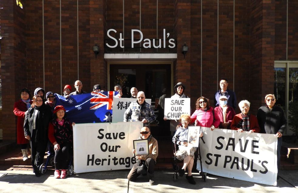
1920s · 1973 New Cities Campbelltown Camden Appin Structure Plan · Aesthetics · Agriculture · Attachment to place · Belonging · British colonialism · Camden · Camden Council · Camden Story · Camden Town Centre · Cobbitty · Colonial Camden · Colonial frontier · Colonialism · Community identity · Cowpastures · Cultural Heritage · Cultural icon · Curtilage · Denbigh · Dharawal · Economy · Edwardian · England · Farming · Frontier violence · Georgian · Gothic · Governor Macquarie · Heritage · Historical consciousness · Historical Research · Historical thinking · History · Interwar · Landscape · Landscape aesthetics · Living History · Local History · Local Studies · Macarthur · Memory · Menangle · Modernism · Place making · Ruralism · Sense of place · Settler colonialism · Storytelling · Town planning · Urban growth · Urban Planning · Victorian

Hope, heritage and a sense of place – an English village in the Cowpastures

Camden Heritage Conservation Area

In 2006 Camden Council designated the Camden town centre as a  Heritage Conservation Area, and later incorporated it in the  2010 Local Environment Plan. A heritage conservation zoning, according to Camden Council, is :

 an area that has historic significance… [and]… in which historical origins and relationships between the various elements create a sense of place that is worth keeping.

Map Camden Town Centre HCA LEP 2010 CRAG
Map of the Camden Town Centre Heritage Conservation Area from 2010 Local Environment Plan. (Taken from 2016 Camden Residents Action Group Submission for State Listing)


Historic significance

Several writers have offered observations on Camden’s historical significance.

Historian Ken Cable argued in the 2004 Draft Heritage Report prepared by Sydney Architects Tropman and Tropman that: Camden town is a significant landmark in the LGA.  

In 2006 Sydney architect Hector Abrahams stated that Camden was ‘the best-preserved rural town in the entire Cumberland Plain’ (Camden Advertiser, 28 June 2006).

Hector Abrahams -best preserved- Camden Advertiser 2006 Jun28
Comment by architect Hector Abrahams that Camden was the best preserved country town rural town in the Cumberland Plain. Camden Advertiser 28 June 2006.


Historian Alan Atkinson has argued that Camden is ‘a profoundly important place’, while historian Grace Karskins maintains that ‘Camden is an astonishingly intact survival of early colonial Australia’.  


Sense of place

In the early 20th century poets, artists and writers waxed lyrical that the town was like ‘a little England’.

Camden Council documents stress the importance of rural nature of the town for the community’s sense of place and community identity.

Camden Aerial 1940 CIPP
An aerial view of Camden township in 1940 taken by a plane that took off at Camden airfield. St John’s Church is at the centre of the image (Camden Images)


This is quite a diverse range of views.

This blog post will look at the historical elements that have contributed to the town’s sense of place, and ultimately its historical significance.

While none of these elements is new, this is the first time they have been presented this way.


A private venture of Englishmen James and William Macarthur

The village was a private development of Englishmen James and William Macarthur on the family property of Camden Park Estate.

The Macarthur brothers had their private-venture village of Camden approved in 1835, the street plan drawn up (1836) and the first sale of land in 1841.  All within the limits of Camden Park Estate.

The Macarthur brothers had another private venture village at Taralga on Richlands and Menangle on Camden Park Estate.

Camden James Macarthur Belgenny
James Macarthur (Belgenny Farm)

Creation of a little English village

The notion of an English-style village on the family estate must have been an enticing possibility for the Macarthur brothers.

In the Camden village, James and William Macarthur named streets after themselves and their supporters. They include John Street, Macarthur Road, Elizabeth Street, Edward Street, Broughton Street, Exeter Street, Oxley Street, Mitchell Street. The Macarthur family and funded the construction of St John’s church on the hill and donated the surrounding curtilage.

St Johns Church
St Johns Church Camden around 1900 (Camden Images)

The Macarthur brothers created vistas from the family’s Georgian hilltop Georgian mansion across the Cowpastures countryside to their Gothic-style village church.

The Englishness of the Camden village entranced many visitors and locals, including artists and writers. On a visit in 1927, the Duchess of York claimed that the area was ‘like England.’


Strategic river crossing into the Cowpastures

The village was strategically located at the Nepean River ford where the first Europeans crossed the river. By the 1820s the river crossing was the main entry point to Macarthur brothers’ Camden Park Estate, the largest gentry property in the area.

The situation of the village on the Great South Road re-enforced the Macarthur brothers economic and social authority over the countryside.

The river crossing was one of the two northern entry points to their realm of Camden Park Estate, the other being at the Menangle.  Menangle later became another private estate village.

The Macarthur village of Camden would secure the northern entry to the family’s Camden Park estate where the Great South Road entered their property. By 1826 the river ford was the site of the first toll bridge in the area.

Camden Cowpastures Bridge 1842 Thomas Woore R.N. of Harrington Park CIPP


None of this was new as the river crossing had been the entry into the Cowpastures reserve declared by Governor King in 1803. The site was marked by the police hut in the government reserve at the end of the Cowpasture track from Prospect.


English place names, an act of dispossession

The Camden village was part of the British imperial practice of placing English names on the landscape. The name of the village is English as is the gentry estate within which it was located – Camden Park.

English place names were used in the area from 1796 when Governor Hunter names the site the Cow Pastures Plain. The Cowpastures was a common grazing land near a village.

Naming is a political act of possession, or dispossession, and is an active part of settler colonialism.

Camden Signage
The Camden sign on the entry to the town centre at Kirkham Reserve on Camden Valley Way formerly The Great South Road and Hume Highway. (I Willis)


The Cowpastures was a meeting ground in between the  Dharawal, the Dharug and the Gundungurra people. The area was variously known as ‘Baragil’ (Baragal)’ or Benkennie (dry land).

Indigenous names were generally suppressed by English placenames until recent decades.

Initially, the Wild Cattle of the Cowpastures that escaped from the Sydney colony in 1788 occupied the meadows of the Nepean River floodplain.

The Cowpastures became a contested site on the colonial frontier.


Dispossession in the English meadows of the Cowpastures

The foundation of the Macarthur private village venture was part of the British colonial settler project.

The first Europeans were driven by Britain’s imperial ambitions and the settler-colonial project and could see the economic possibilities of the countryside.

Under the aims of the colonial settler project, as outlined by Patrick Wolfe and later LeFevre, the new Europeans sought to replace the original population of the colonised territory with a new group of settlers.

Hunter’s naming of the Cowpastures was the first act of expropriation. Further dispossession occurred with the government reserve, and later Governor Macquarie created the government village of Cawdor in the centre of the Cowpastures.

Art Governor Macquarie SLNSW
Governor Macquarie SLNSW


The Europeans seized territory by grant and purchase and imposed more English place names in the countryside, and created a landscape that mirrored the familiarity of England.

The colonial settlers brought Enlightenment notions of progress in their search for some kind of utopia.


Cowpasture patriarchs

The Macarthur private venture village was located in a landscape of self-style English gentry, and their estates interspersed with several small villages.

The gentry estates and their homestead and farm complex were English style village communities. One of the earliest was Denbigh (1818).

denbigh-2015-iwillis
Denbigh Homestead Open Day 2015 IWillis


The oligarch-in-chief was Camden Park’s John Macarthur.

The Europeans used forced labour to impose English scientific farming methods on the country.

The Cowpasture colonial elite created a bunyip aristocracy and styled themselves on the English gentry.

On the left bank of the Nepean River were the gentry estates of Camden Park along with Brownlow Hill. On the right bank were the gentry properties of Macquarie Grove, Elderslie, Kirkham and Denbigh and several smallholders.

The ideal society for the colonial gentry included village communities. To foster their view of the world, the Europeans created the small village of Cobbitty around the Hassall family’s private Heber Chapel.

The village of Stonequarry was growing at the southern limits of the Cowpastures at the creek crossing on the Great South Road.  The village was located on the Antil’s Jarvisfield and later renamed Picton in the 1840s.

The picturesque Cowpastures countryside greeted the newly arrived Englishmen John Hawdon from County Durham. In 1828 Hawdon became the first person to put in writing that the Cowpastures area reminded him of the English countryside when he wrote a letter home.


The progress and development of the country town

The Enlightenment view of progress influenced the Macarthur’s vision for their Camden village. They sought to create an ideal village community of yeoman farmers and sponsored self-improvement community organisation including the School of Arts.

Camden School of Arts PReeves c1800s CIPP


Within the Macarthur fiefdom, former estate workers became townsmen, took up civic duties and ran successful businesses.

The village of Camden prospered, became a thriving market town and the economic hub of a growing district.

The architectural styles of the town centre shine a light on the progress and development of the Macarthur village. The architectural forms include  Georgian, Victorian, Edwardian, Interwar moderne, Mid-20th century modern, and Post-modern.

The town centre served a host of functions for the community that are indicated by the types of land use in a country town. These include commercial, government, open space, industrial, transport, residential, religious, agricultural, amongst others.


The country town idyll and the appearance of heritage

Since the 1973 New Cities Structure Plan for Appin, Campbelltown and Camden there has been increased interest in the cultural heritage of the town centre. This is the first appearance of the influence of post-modernism in the Camden story.

The New Cities Plan 1973[1]
The New Cities Structure Plan Campbelltown Camden Airds 1973
John Wrigley conducted the first heritage study of the Camden town centre in 1985 for the Camden Historical Society.

Urban growth and the loss of rural countryside has encouraged a nostalgic desire for the past. This process had led to the evolution of the Camden, the country town idyll.

The heritage of the town centre is what the community values from the past that exists in the present. It is made up of tangible and intangible heritage, as well as multi-layered and multi-dimensional. The town centre story can is a timeline with many side shoots or a tree with the main stem and many branches.


Camden time traveller and the town centre

The living history of the town centre is evident at every turn. At every corner. A visitor can be a time-traveller into the past. A view along the main street is a view into the past.

There are many locations in our local area where a person can be a time-traveller into the past. The traveller can be a participant in the area’s living history, ‘simply by being present’.

One of these sites is the commanding view from the hilltop at St John’s church. Here the traveller can view the Cowpasture countryside that nestles the Camden town centre within its grasp.

Cover  Pictorial History Camden District Ian Willis 2015
Front Cover of Ian Willis’s Pictorial History of Camden and District (Kingsclear, 2015)
Adaptive Re-use · Aesthetics · Architecture · Art · Attachment to place · Australia · Camden · Churches · Community identity · Cultural Heritage · Cultural icon · Curtilage · Georgian · Gothic · Heritage · Historical consciousness · Historical Research · Historical thinking · History · Landscape aesthetics · Lifestyle · Living History · Local History · Local Studies · Macarthur · Memory · Monuments · Myths · Place making · Ruralism · Sense of place · Streetscapes · Trust · Victorian · Weddings

The local church as a centre of place

A centre of place

In Camden the local non-going church community has resisted the sale by the Anglican Church of a horse paddock between St John’s Anglican Church and the former Rectory, all part of the St John’s Church precinct.

Community angst has been expressed at public meetings, protests, placards, and in articles in the press.

St Johns Church
St Johns Church Camden around 1900 (Camden Images)


The purpose of this blog post is to try and unravel some of the broader issues underpinning community angst around the sale of church property. The post will look at the case study of the sale of churches in Tasmania and the resultant community anxiety.

The local church in place

The local church is an important part of a local community. It has a host of meanings for both churchgoers and non-churchgoers alike.

The local church is a central part of the construction of place and people’s attachment to a cultural landscape and locality.

Place is about a sense of belonging and a sense of groundedness. It is expressed by cultural heritage, memory, nostalgia, customs, commemorations, traditions, celebrations, values, beliefs and lifestyles.

Belonging is central to placeness. It is home. A site where there is a sense of acceptance, safety and security. Home as a place is  an important source of stability in a time of chaos. Home is part of a community.

LM Miller from the University of Tasmania states that people are involved fundamentally with what constitutes place and places are involved fundamentally in the construction of persons. Place wraps around and envelopes a person. People are holders of place (Miller: 6-8)

There is a shared sense of belonging in a community where being understood is important and part of a beloved collection. A sense of belonging acts as an all encompassing set of beliefs and identity. . It enriches our identity and relationships and leads to acceptance and understanding.

A church is one of these communities.

Cobbitty St Pauls 1890s CKerry 'EnglishChurch' PHM
This Charles Kerry Image of St Paul’s Anglican Church at Cobbitty is labelled ‘English Church Cobbitty’. The image is likely to be around the 1890s and re-enforces the notion of Cobbity as an English-style pre-industriral village in the Cowpastures (PHM)


When a person’s sense of place is threatened then their sense of self, identity, safety, stability, and security are challenged. Where there is a loss of a person’s sense of place and belonging to a place they go through a grieving process.

The closure, sale and de-consecration of the local church are a threat to a person’s sense of place.

Local churches are part of a community’s cultural heritage.

Local churches are part of a community’s cultural heritage.

Cultural heritage consists of two parts. Firstly, tangible heritage which is made up, for example, buildings, art, objects and artefacts.

Secondly there is intangible cultural heritage which includes customs, practices, places, objects, artistic expressions and values.  This can be extended to include traditional skills and technologies, religious ceremonies, performing arts and storytelling.


Churchgoers and a sense of place

The link between local churches and a community’s sense of place  has been explored  by Graeme Davison in his book The Use and Abuse of Australian History. He says that churchgoers are often faced with unsustainable maintenance costs for a church. Eventually when churchgoers are forced to sell the property they:

often seemed less reluctant to give up their church than the rest of the community…and faced with the prospect of its loss, [the non-churchgoers] were often prepared to fight with surprising tenacity to save it.’ (Davision:149)

Enmore Church of Christ Tabernacle
The Enmore Church of Christ Tabernacle in the early 20th century where Frank and Ethel were married in 1925. (Jubilee Pictorial History of the Church of Christ)


These churches have a strong emotional attachment for their communities. These churches are loved places for their community and Davison suggests:

It is in losing loved places, as well as loved persons, that we come to recognise the nature and depth of our attachment to our past. (Davison: 150)

Davison argues that churchgoers often have a loyalty to their local place well beyond their sense of faith in Christianity.

Sale of churches in Tasmania

These issues came to the fore in Tasmania in 2018 when there was  public outrage around the sale of local churches in Tasmania.

The Hobart press ran a story with the headline ‘Emotions run high, communities vow to fight after Anglican Church votes to sell off 76 churches’. (Sunday Tasmanian, 3 June 2018)

tasmania st john's anglican church-ross-tasmania wikimedia lowres
St John’s Anglican Church Ross Tasmania (Wikimedia 2017)

The Anglican Church in Tasmania was attempting to fund the ‘redress commitment’ to the victims of clerical abuse by selling church property.

In response Central Tasmanian Highlands churchgoer Ron Sonners said that  ‘his ancestors [were] buried in the graveyard associated with St Peter’s Church at Hamilton’…and he ‘struggled with his emotions as he dealt with the fallout from his community church being listed for sale’.  (Sunday Tasmanian, 3 June 2018)

Tasmania Anglican Bishop Richard Condie says that most of opposition to the sale of churches

 is primarily people in the broader community who oppose the sales, with the potential loss of heritage and family history, including access to graveyards, their main concern. (The Mercury, 15 September 2018)

There have been protest meetings and some effected parishes started fundraising campaigns to keep their churches.  The Hobart Mercury reported that

The Parish of Holy Trinity Launceston, which wants to keep St Matthias’ Church at Windermere, has raised the funds, with the help of its local community, to meet its redress contribution. (The Mercury, 15 September 2018)

Cultural historian and churchgoer Dr Caroline Miley said that:

the churches are an important part of Australian history… It is unconscionable that such a massive number of buildings, artefacts and precincts should be lost to the National Estate in one fell swoop…These are buildings built and attended by convicts and their jailers. They were built on land donated by early state governors, notable pioneers and state politicians, with funds donated by these colonials and opened by the likes of Sir John Franklin…As well, she says, they contain the honour boards, memorials and graves of those who fought and died in conflicts from the 19th century onwards…Some are in the rare (in Australia) Georgian style or in idiosyncratic Tasmanian Carpenter Gothic. (The Mercury, 15 September 2018)

Amanda Ducker of the Hobart Mercury summarises of the whole fuss surrounding the sale of churches in Tasmania this way:

Condie’s use-it-or-lose-it approach clashes with the keep-it-at-all-costs mentality. But while some opponents of the bishop’s plan refuse to sell their church buildings, neither do they want to go to church regularly. They rather prefer just to gather on special occasions: baptisms, weddings, funerals and perhaps at Christmas and Easter if they are leaning towards piety. But the rest of the year? Well, a sleep-in, potter at home or cafe brunch of eggs benedict (but sans ministering) are pretty tempting on Sunday morning. (The Mercury, 15 September 2018)

Others Anglicans in Tasmania see the whole argument differently. Emeritus Professor and Anglican Peter Boyce AO see it as fight over the spiritual traditions linked to the low and high Anglican traditions in Tasmania.   (The Mercury, 15 September 2018)

All these arguments are characteristic of how people, their traditions, their values, their past, their memories are all rooted in a location and in particular a building like a church.


Other dimensions to the argument

The dualism expressed in the sale of church land and buildings can be likened to the difference between sacred and secular. These two polar opposites are explored in popular culture in the form of music by Nick Cave and others on The Conversation.

Another perspective on this area was aired on ABC Radio Local Sydney in December 2018 by Dr David Newheiser. In the discussion he examined  the differences between Christians and aethiests.  He maintained that there are strong sentiments in the community around tradition and ritual in the community and if you lose a church you lose all of this.

The binary position of churchgoers and non-churchgoers can also be expressed in ethical terms as the difference between good and evil, or right and wrong, or moral and immoral, just and unjust and so on. This dichotomy has ancient roots dating back to pre-Biblical times across many cultures.

So what does all this mean?

Churches have an important role to play in the construction of place in communities. This role is played out in different ways for different actors in the story.

As far as the dichotomy presented here in the story of the sale of church property and land, there is really no conclusion that satisfies all stakeholders.

There is no right or wrong position to the opposing views between churchgoers and non-churchgoers. The differences remain an unresolved ethical dilemma.

An iconic Camden image of St Johns Anglican Church in the 1890s.

Cover Pictorial History Camden District Ian Willis 2015
Front Cover of Ian Willis’s Pictorial History of Camden and District (Kingsclear, 2015)

Aesthetics · Architecture · Art · Attachment to place · Colonialism · Community identity · Convalescent Home · Convalescent hospital · Cultural Heritage · Cultural icon · Curtilage · Dairying · Edwardian · Entertainment · Festivals · Heritage · History · Interwar · Landscape aesthetics · Leisure · Local History · Medical history · Modernism · Place making · Red Cross · Sense of place · Volunteering · War · War at home · Yaralla Estate, Concord

A hidden Sydney gem: Yaralla Estate

The CHN blogger was out and about recently and visited one of Sydney’s hidden gems that very few people seem to know about. It is the splendid and historic Yaralla Estate at Concord NSW.

Concord Yarralla Estate Front Paddock (2018)
The entrance paddocks of the Yaralla Estate which is a highly significant example of a large nineteenth estate in the Sydney area. It is a rare example because it incorporates an entire 1790s land grant within its boundaries (I Willis, 2018)

The Yaralla estate has a colourful history and the site has been occupied by some famous Australians.

Concord Yarralla Estate Woodbine 1833 (2018)
Woodbine Cottage. This is the oldest building on the Yaralla Estate dating from before 1833 and built by the family of Isaac Nichols shortly after his death. It is a timber cottage and has been modified since its completion. (I Willis, 2018)

One of the first was former convict Isaac Nichols, Australia’s first postmaster (1809).

Concord Yaralla Estate 2018 Driveway
Yaralla Estate Driveway approaching Yaralla House. Described by the State Heritage Inventory as ‘composed of brush box (with the occasional eucalypt exception) and runs from the entrance gates between grassed west and east paddocks (until recently containing horses) leading to the inner set of estate gates and fencing containing the homestead, dairy complex, stables and parkland garden’. (I Willis, 2018)

The next prominent owner was Sydney banker and philanthropist Thomas Walker acquiring the property from Nichols sons in the 1840s. He commissioned Sydney architect Edmund Blacket to design a large two-story Victorian mansion called Yaralla house. Walker died in 1886 and left the estate in trust to his only daughter Eadith.

Thomas left a bequest of 100,000 pounds from his will for the construction of the Thomas Walker Convalescent Hospital in the western portion of the Yaralla estate.

Concord Yarralla Estate House 1850s (2018)
Thomas Walker’s Yaralla House. Edmund Blacket designed stage 1 in 1857 with additions by John Sulman 1893-1899. The house was converted to a hospital in 1940 as the Dame Eadith Walker Convalescent Hospital. (I Willis, 2018)

Sydney architect Sir John Sulman was commissioned to extend the house in the 1890s. He extended the second floor of the house and designed a number outbuildings including the dairy and stable buildings.

Concord Yarralla Estate Stables2 (2018)
The Arts and Crafts inspired stables were designed by John Sulman between 1893 and 1899. The complex was originally used as a coach house and stables and later as garages, office and storage space. (I Willis, 2018)

Yaralla House and the grounds are strikingly English-in-style and layout. The Arts and Crafts influenced Sulman buildings are set in the idyllic setting of an English estate garden and park.

Concord Yarralla Estate Dairy 1917 (2018) CCBHS
The dairy, a U-shaped building inspired by Arts and Crafts design were part of the John Sulman estate works. This image taken in 1917 shows the predominantly Jersey dairy herd which at one stage had 1200 cows and produced 300 gallons per day. (CCBHS Display)

The Dictionary of Sydney states that the top part of the estate

were sub-divided in 1908, 1912, and 1922, becoming estates of Federation and Californian bungalow homes built for soldiers after World War I.

Concord Yarralla Estate Subdivision 1908 (2018) CCBHS
The Walker Estate at Concord. The subdivision was sold at public auction on 21 November 1908. The streets included Gracemere, Beronia, Waratah and Alva Streets. The sale was organised by Auctioneers Raine & Horne at their Pitt Street offices. Over 125 blocks were offered for sale. (CCBHS Display)

Yaralla House was the ‘hub of Sydney society’ in the Interwar period, according to the Dictionary of Sydney.  Eadith Walker who lived at the house during this period was a  famous Sydney philanthropist and held many charity events on the property.

Concord Yarralla Estate Boronia2 (2018)
Boronia Cottage. This was the residence for the dairy manager and was next to the dairy complex. It is a single story cottage with a hipped and gable roof inspired by Arts and Crafts design. It was part of the John Sulman estate’s works. (I Willis, 2018)

Dame Eadith Walker (CBE, 1918, DBE, 1928) never married and left a large estate when she died in 1937. The estate finally came under the Walker Trust Act 1939.

Concord Yarralla Estate Stables Courtyard2 (2018)
The courtyard of the English-style stables and coach house complex. Designed by John Sulman influenced by Arts and Crafts styling. The central courtyard has a ‘rich assortment of decorative elements such as towers, lanterns, a clock and dormer windows’, according to one source. It has living quarters and a horse enclosure. (I Willis, 2018)

Yaralla House was a convalescent hospital after the Second World War and then fell into disrepair. Much conservation work has been carried out in recent decades.

Concord Yarralla Estate 2018 Stonework
The balustrade separates the top and lower terraces adjacent to Yaralla House with views of Sydney Harbour. The top terrace was a crochet lawn, while tennis courts occupied the lower terrace. The balustrade is ‘symmetrical marble and freestone with formal central stairway’, according to a source. Today’s foreshore walkway is in the far distance. (I Willis, 2018)

The property had many important visitors over the years from royalty to the vice-regal.

Concord Yarralla Estate Squash Court (2018)
The squash court built by Eadith Walker for a visit by the Prince of Wales in 1920. It is regarded as substantially intact and is an important surviving recreational element on the property. It has elements of Arts and Craft influence similar to estate works by John Sulman. It is reputed to be the first squash court built in Australia (I Willis, 2018)

 A ‘secret’ walking trail

The area has a ‘secret’ walking trail along the Sydney Harbour Foreshore. Well known to locals. Little known to outsiders. The walkway includes the Kokoda Track Memorial Walkway from Rhodes Railway Station to Concord Hospital (800 metres). It is all part of the Concord Foreshore Trail. This walk is described this way on the City of Canada Bay walks website:

This historic and peaceful walk stretches from McIlwaine Park in the Rhodes to Majors Bay Reserve in Concord. The route encircles the mangrove-fringed Brays Bay, Yaralla Bay and Majors Bay on the Parramatta River and goes around the former Thomas Walker Hospital ( a heritage listed building), Concord Repatriation General Hospital and the historically significant Yaralla Estate (one of the oldest estates in Sydney dating back to the 1790’s).

These are all part of the Sydney Coastal Walks.

Appin · Architecture · Attachment to place · Australia · British colonialism · Campbelltown · Colonial frontier · Colonialism · Communications · Community identity · Cowpastures · Cultural Heritage · Cultural icon · Curtilage · Dairying · Farming · Frontier violence · Governor Macquarie · Heritage · Historical consciousness · Historical Research · Historical thinking · History · Landscape aesthetics · Local History · Local Studies · Macarthur · Monuments · Place making · Ruralism · Sense of place · Settler colonialism · Sydney's rural-urban fringe · Town planning · Transport · Urban growth · Urban Planning · urban sprawl · Urbanism · Victorian

Beulah and Sydney’s Urban Sprawl

Beulah is an historic farm property on Sydney south-west rural-urban fringe. Beulah has a frontage to Sydney’s notorious Appin Road and is an area of Sydney’s ever increasing urban sprawl. The property is caught in a pincer movement between two new land releases at Appin and Mount Gilead. These developments  threaten to strangle the life out of Beulah is a vast sea of homogenised suburbia by swallowing up local farmland.


beulah-cdfhs
Beulah Appin Road Campbelltown CDFHS

In 2015 NSW Planning Minister Stokes declared that Sydney’s  ‘urban sprawl is over’ with the land release for 35,000 new homes at Mount Gilead, Wilton and Menangle Park.  On the other hand planning Professor Peter Phibbs, from the University of Sydney, stated that the land release meant that there was ‘urban sprawl plus’. [1] Needless to say these sentiments are not new and were expressed in the Macarthur region in 1973, meanwhile urban sprawl continues.

Beulah

Beulah is a heritage gem and possesses stories about local identities and events that add to a sense of place and construction of a local identity. Beulah was purchased by the Sydney Living Museums in 2010 as part of its endangered houses fund project.

The Beulah estate is located on the eastern edge of the clay soils of the Cumberland Plain abutting the Sydney sandstone of the Georges River catchment.  The property contains an 1830s stone farm cottage with a number of out-buildings, a stone bridge and 60 hectares of critically endangered woodland.

Beulah’s sense of place is constructed around stories associated with the Campbelltown’s pioneering Hume family best known for Hamilton Hume and his overland journey to the Port Phillip area in 1824-1825 with William Hovell. Hamilton Hume was granted 300 acres at Appin for this work, which he named ‘Brookdale’, and in 1824 the Hume and Hovell expedition to Port Phillip left from this property on the Appin Road north of the village, near where the Hume and Hovell Monument now stands. The Hume Monument was erected in 1924 by the Royal Australian Historical Society to commemorate Hume’s 1824 expedition.


hume-mon-appin-rd-2016
Hume Monument Appin Road Appin 2016 (I Willis)

The earliest European occupation of the Beulah site, according to Megan Martin from Sydney Living Museums, were emancipated Irish convict Connor Bland who constructed the farm cottage around 1835-1836.

Boland put the property up for sale in 1836 and called it Summerhill. The Hume family purchased the property in 1846 and then leased it out. In 1884 the property was renamed Beulah and members of the Hume family lived there until 1936 when it was left to the RSPCA while Hume family associates were given  occupancy rights and  lived in the house until the 1960s.

According to the State Heritage Inventory

Ellen Hume and Beulah were featured in “The Australian Home Beautiful” in 1934 in an article by Nora Cooper, photographs by Harold Cazneaux and descriptions of Hume family furniture. The forest which Miss Hume treated as a private sanctuary The Hume Sanctuary received special attention. It was Ellen’s wish that her trees be left to the nation….


beulah-cottage-2016
Beulah Cottage 2016 (I Willis)

The Beulah estate was purchased by developers in the 1970s who anticipated land re-zoning  linked with the 1973 New Cities Structure Plan for Campbelltown, Appin and Camden. The state government released  the New Cities Plan as part of the 1968 Sydney Region Outline Plan. The plan was based on the utopian dream of British New Towns like Milton Keynes and plans for the development of Canberra.

Some of the new Campbelltown suburbs that appeared in the 1970s followed the Radburn model developed in the United States, which had houses facing a shared green space with no back fences. They turned out to be a disaster and the state government has spent hundreds of millions of dollars reversing these houses so they face the street in suburbs like Macquarie Fields, Minto and Ambarvale.

The original New Cities Plan turned into a developers dream and created the notion of ‘Ugly Campbelltown’ in the Sydney press by the end of the 1970s around public housing . Camden and Appin escaped the worst of the housing releases of the 1970s. Sydney’s urban sprawl reached the Camden LGA in the 1980s at Mount Annan and Currans Hill, while Appin has only seen extensive land releases in recent years.  The 1973 Macarthur Growth Centre failed to materialise in its planned form and in the process cannibalised Campbelltown’s main street and left it a shell of its former country town self.


Beulah Appin 2016 (I Willis)

In 1973 the State Planning Authority, according to the State Heritage Inventory, conducted a survey of significant 19th buildings in 1973 and identified Beulah and Humewood as significant. The National Trust of Australia (NSW) did a study on the property and classified it in 1980.

In 1983 Campbelltown City Council proposed an interim conservation order and a permanent conservation order was placed on the 19th century cottage in 1987. The owners were ordered to make repairs to the property in the early 2000s, and the in 2010 the NSW Office of Heritage and Environment acquired the property as part of the state government’s Biodiversity Offset program.


biobank-signage-beulah

The  State Heritage Inventory considers the estate to an important example of early conservation planning that resulted in the retention of an ‘entire cultural landscape’ containing a homestead group, stone bridge and garden layout.  Sydney Living Museums have undertaken considerable conservation and restoration work on the farmhouse and the stone bridge on the access road to the farm house.


beulah-convict-bridge-2016
Convict constructed bridge at Beulah Farm Estate 2016 (I Willis)

New land releases around Beulah

Beulah and its heritage curtilage is potentially threatened by Sydney’s urban sprawl with new land releases in 2013 at Appin to the south along the Appin Road, while to the north there is the Mount Gilead land release adjacent to Campbelltown’s southern suburbs. Both of these land releases are a repeat of the 1973 housing releases. They are low density horizontal developments that add to urban sprawl. They are problematic and fail to add to the existing identity of the area and take decades to develop their own sense of place.


mount-gilead-farmland-2016
Mount Gilead Farmland at Campbelltown 2016 (I Willis)


The urban sprawl that is encroaching on Beulah from the south is part of the NSW State Governments 2013 The  Metropolitan Strategy for Sydney to 2031.  A structure plan developed for the Appin area states that there will 18,300 housing lots release over a 25 year period from around 17,000 hectares. Walker Corporation stated that there is a strong demand for new housing releases in the Appin area and in 2013 26 lots were sold within 2 days of the June land release.[2] There low density houses were similar to in nature to the planned housing developments of 1973 that failed to eventuate.


appin-walker-dev-2016
Land Release Walker Corporation Appin 2015 (I Willis)

On the northern approaches to Beulah are the Mount Gilead land releases on a property formerly owned by Lady Dorothy Macarthur Onslow who died in 2013.  Mount Gilead is proposed to have  1700 housing lots from 210 hectares which Campbelltown City Council endorsed in 2012.[3] The property contains the historic tower-mill believed the last one in New South Wales along with a homestead, stone stable, and granary dating from the early 19th century.

Appin Road a deadly lifeline

The issue of urban sprawl is complicated by the inadequate road access. Beulah and the Appin and Mount Gilead land releases all front the Appin Road one of Sydney’s most dangerous stretches of road. A major unresolved issue in the area around Beulah and land releases at Appin and Mount Gilead is the upgrading of the Appin Road.

The Sydney Morning Herald stated in early 2016 that the Appin Road was Sydney’s deadliest road. Between 2015 and 2000 23 people were killed on the Appin Road with the latest fatality in January 2016. While the state government has plans for road improvements this will take a number of years meanwhile there is increased traffic generated by new land releases and general population growth of the Campbelltown area.

The Appin Road has always been an important access route between the Illawarra and the Campbelltown area. Before the  South Coast railway was extended to Wollongong in 1887 the Appin Road was used as the main access route  to the Main Southern Railway at Campbelltown, which opened in 1858. There was a daily coaching service running between Campbelltown Railway Station and Wollongong. There is still is daily coach service between Campbelltown and the Illawarra via Appin, although tese days it mainly caters to university students.

The poor state of the Appin Road is just one of the issues created by Sydney’s urban sprawl.   Other issues include fire risks, urban runoff and food security, public transport, waste, water supply, loss of prime farm land, community facilities, pollution, energy, social cohesion, and equity challenges. Beulah is part of story of the Sydney’s rural urban fringe which has been a landscape of hope and loss for new arrivals and local alike. It will be interesting to see the part this important heritage asset plays in this narrative and how the construction of sense will effect new residents surrounding it.

In 2019 Sydney historian Stephen Gapps has written about the defensive structures in buildings in the Appin area including Beulah. These buildings were part of the colonial frontier of New South Wales where there were violent clashes between Europeans and Indigenous people. There is evidence that rifle slits and gun loops were were of the colonial architecture at Beulah and the Vines near Appin.

Further reading

Alan Gilpin, An Inquiry pursuant to Section 41 of the Heritage Act 1977 into objections to the making of a permanent conservation order in respect of the buildings and site known as “Beulah”, Appin Road, Appin. Sydney : Office of the Commissioners of Inquiry for Environment and Planning, 1987.

Notes

[1] Melanie Kembrey, ‘Planning Minister Rob Stokes unveils plans to create three new communities south of Campbelltown’. The Sydney Morning Herald 22 September 2015. Online @ http://www.smh.com.au/nsw/planning-minister-rob-stokes-unveils-plans-to-create-three-new-communities-south-of-campbelltown-20150922-gjs8ev.html (accessed 28 November 2016)

[2] Walker Corporation, Submission to the Draft Metropolitan Strategy for Sydney 2031, An Appin Urban Release Area (Sydney: Walker Corporation, 2013), p22

[3] Kimberley Kaines, ‘Call for more details on Mt Gilead development’, Macarthur Chronicle, 19 February 2015.

Aesthetics · Agriculture · Attachment to place · Australia · Belonging · British colonialism · Colonial Camden · Colonial frontier · Colonialism · Community identity · Convicts · Cowpastures · Cultural Heritage · Cultural icon · Curtilage · Economy · Elderslie · England · Farming · Frontier violence · Georgian · Gothic · Heritage · Historical consciousness · Historical Research · Historical thinking · History · Landscape · Landscape aesthetics · Local History · Local Studies · Macarthur · Narellan · Place making · Ruralism · Sense of place · Settler colonialism · Storytelling · Stuart Park Wollongong

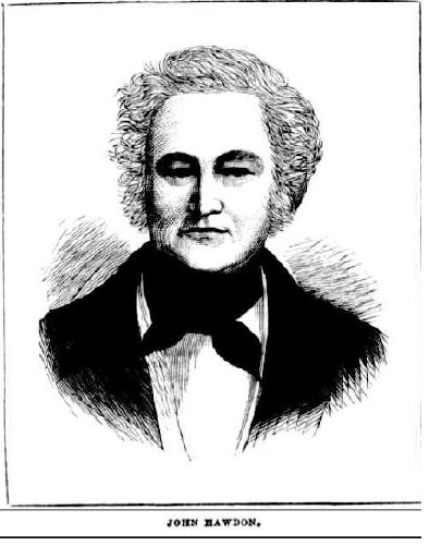
John Hawdon of Elderslie in a settler society

Englishman John Hawdon

John Hawdon
John Hawdon

In 1929 Mrs Madeline Buck the grand-daughter of an Elderslie pioneer James Hawdon published a series of his letters written in 1828 to friends in England. Hawdon had lived in the Elderslie area for five years from 1828.

Hawdon’s letters surfaced in England in 1929 amongst old family papers and have many interesting insights into life in the early days of the colony.

At Elderslie, Hawdon leased the Elderslie estate and supported four convicts, his wife Margaret and baby son. Alan Atkinson maintains that ‘Hawdon apparently tried to keep up an English tone, with the slave-driving Botany Bay element at a minimum. He was a good master and even admired his convicts’. He did not take any convicts for punishment at the Cawdor Bench between 1825 and 1830. (Atkinson, p20)

Hawdon was concerned about freight costs between Sydney and the Cowpastures and according to Atkinson ‘could make a good profit only because his carriers were his own convicts, who cost him next to nothing. The journey to market and back took a week’ using a bullock team. Hawdon grew hay for the Sydney market which was used to fatten cattle for market, and by the 1830s hay was more important than grain for the property owners in the Cowpastures. Hawdon’s convicts took the hay to the Sydney market and sold it for 6s8½d a hundredweight in 1832. He also grew a small amount of tobacco, which according to Atkinson, was ‘very profitable’ for those who knew how to grow it.

Hawdon wrote to England of the Elderslie estate convicts that

‘he had a good many of what he almost always calls “Government men,” and said he always had great satisfaction from them.’

He continued that

‘I allow my men to have as much new milk as they can use. I feed them well, and work ttipm well, by which means I have very little trouble managing them.” (SMH, 26 Oct 1929)

Hawdon was one of many colonists who moved into southern New South Wales after living in the Cowpastures for a period. He was one of the colonists who were at the frontier of the settler society where clashes between Europeans and Aborigines were more common than not.
In 1879 a journalist for the Australian Town and Country Journal described Hawdon as

‘I am only doing justice to a good old colonist, and but expressing the general opinion by stating that Mr. Hawdon is about one of the finest representatives of the true British gentleman in the colony. Honour, hospitality, and generosity are the’ characteristics which have marked his long life’ of usefulness in working and opening out with a few other pioneers this rapidly peopling district.’

‘The gentleman whose portrait we present to our readers this week is one of our oldest colonists, and the record of his career is a typical one of the prosperity that in this country attends upon energy and perseverance.’

In his obituary in 1881 the writer maintained that:

‘With his we believe, passes away that last of the brave men who did so much, to open-up the-pastoral interest of Australia and to give her the name of the finest grazing country in the world.’

At Elderslie, he ran dairying and cheese making and later his property at Bodalla. He contracted to supply provisions to the road gangs making the Great South Road.

Hawdon wrote about his journey out to New South Wales and writing on October 26, 1828, he stated

“Our passage was tedious, but not unpleasant.In the cabin we carried ten people, and in the steerage I believe there were about 32. My cabin was a very comfortable one on deck. We carried on board eight dogs, about 40 sheep, pigs, and poultry In abundance, a cow, a goat with two kids, and a famous noise, I assure you, they made!”

He wrote in his diary

On the arrival of the small family In Sydney, he found the expenses about double what they would be in London, so “I thought it advisable to take a station, till I could get my affairs arranged, and our grant of land fixed upon.” Then follows what would surprise even a hustling American. He rode up to Camden on the 16th September (three days after landing), took Mr. Harrington’s place, Elderslie, rode back to Sydney on the 17th, and within a week they were established In their new home and working away as though they were old settlers.

He wrote further

“The Governor has been pleased at two dinner parties to express his sentiments of approbation on me, saying I had begun like one who is determined to do well, for I had not been eight days in the Colony before I had my ploughs going.”

Hawdon describes Elderslie as being

“a very good and very cheap place, 38 miles from Sydney, consisting of about 1700 acres of land, all fenced and divided Into paddocks, 400 acres being cleared and stumped. The cultivated land is capital, better than any I have seen in any part of the world. It is on the Nepean River. For about three or four miles the river parts Mr MacArthur’s land and mine. His house is on the opposite side of the river to mine. We have an excellent house and garden, and the conveniences of stables, arns, etc., are equal to almost any in England.”

Mrs Buck stated

‘The little railway siding of Elderslie shows the locality in which this old homestead once stood. I understand that the foundations and an underground room of the homestead remain, and that a cottage has been built upon the site, with the materials from the old house.’

Hawdon wrote of the social life at Elderslie and Mrs Buck stated that the social life on the Cowpastures a hundred years ago was not as dull as one might think.

“This is the very country for a young man,” he writes “Take the people as a body, they are pleasant, hospitable, and uncommonly gay. Where we live (about 40 miles from Sydney). It is as populous a neighbourhood as any country place in England. We have a great many neighbours. This part is thought to be the most respectable part of the country and we have been called upon by the gentry. Altogether it is very pleasant. This country has more the appearance of England than any foreign country. They are all English people, have English customs, and everything when I look around is almost the same as at home. Our sitting-room has the same furniture, the same servants wait on us that we have been accustomed to see, and even the climate is much like very fine weather in England. We see quite as much company as we like. A visitor here thinks very little of staying two or three days, which is very agreeable. The gentlemen are all well-bred men; indeed, a great many of the larger settlers have been officers either in the army or navy. We ore a long way from a church. I believe our church is eight or 10 miles off (Cobbitty), but we have not yet been there, as our gig has not come from Sydney. But I make a point of reading the church service and a sermon to my people, who all appear, clean and well dressed, on Sunday forenoons.”

Hawdon’s views on Aborigines in the Elderslie area:

‘As for the natives, they are a most peaceable set of beings, They come to beg sugar and tobacco, of which they are fond. They sometimes come to borrow a gun, and I find powder and shot they give me half of what they kill. They are strictly honest and have excellent memories, for if they see a person once they never fail to remember him again, though many years have elapsed. But they are excessively idle.’

Hawdon was extremely energetic and

‘While still holding Elderslie he took a place called Burra Burn (in Northumberland), or 6500 acres, from Archdeacon Scott for seven years. He says that though it was taken for seven years it was rent free.’


John Hawdon, Biography

John Hawdon
John Hawdon


John Hawdon, who was born June 29, 1801, Wakefield, Durham and came out to New South Wales in 1828 on the Caroline with his wife and two children. His wife was Margaret Katherine Hawdon (born Potts) and married her in 1827. One child John was born in 1827 and conceived out of wedlock and the second Gilbert was born at sea on the journey to New South Wales. There were two more children while they lived at Elderslie and their 5th child Ernest was born at Narellan. John Hawdon died June 12, 1881, at Moruya, New South Wales, Australia.

Mrs Buck reported in the Sydney Morning Herald that Hawdon’s youngest daughter, Mrs Annie Wilson, was still living at Mt Colah north of Sydney in 1929. Hawdon had seven sons.

Hawdon took up a grant of 2560 acres at Kiora in the Moruya area in 1831 and later formed a cattle station at Howlong near Albury. He marketed cattle in Melbourne and sold some of the first cattle in Adelaide from New South Wales. He encouraged his brother Joseph to emigrate and together they took up squatting interest in Victoria and south-western New South Wales, contracted the overland mail run between Yass and Melbourne.

Hawdon was one of the young squatters who founded one of Melbourne’s oldest organisations, the old Melbourne Club, a private social club, in 1838. The club is considered an enduring symbol of Australia’s British heritage and was founded by 23 British ‘gentlemen’. The club is located in a London-style clubhouse designed by Leonard Terry in 1858.
Hawdon owned the station of Kiora, Bergalia, Bodalla, Howlong, and one at Mildura, in New South Wales; and similar properties at Mt. Greenock and Dandenong Creek, in Victoria, besides several smaller places.

Further reading

Image and Text:
Australian Town and Country Journal 18 Jan 1879 http://trove.nla.gov.au/ndp/del/printArticlePdf/70934477
Letters
The Sydney Morning Herald 26 October 1929 http://nla.gov.au/nla.news-article16596386
The Sydney Morning Herald 2 November 1929 http://nla.gov.au/nla.news-article16598472
The Sydney Morning Herald 9 November 1929 http://nla.gov.au/nla.news-article16600463
Obituary
The Sydney Morning Herald 16 June 1881 http://nla.gov.au/nla.news-article13488341

Updated 21 April 2020