1968 Sydney Region Outline Plan · 1973 New Cities Campbelltown Camden Appin Structure Plan · Aesthetics · Architecture · Attachment to place · Business · Campbelltown · Campbelltown Council · Campbelltown Municipal Council · Community identity · Cultural Heritage · Cultural icon · Economy · Heritage · Historical consciousness · Historical Research · Historical thinking · History · Living History · Local History · Local Studies · Macarthur · Modernism · Place making · Sense of place · Storytelling · Urban growth · Urban Planning · urban sprawl · Urbanism

A symbol of progress – mid-century modernism and a new administration building

 Campbelltown Council Administration Building

In 1964 the Campbelltown-Ingleburn News ran a banner headline on its front page, SYMBOL OF PROGRESS. The newspaper announced the opening of a new council administration building as part of a proposed civic centre precinct in the town centre.

The newspaper headline was a statement of faith in the confidence of Campbelltown and its planned declaration as a satellite city by the state government.

The eight-storey office building was the tallest structure in the town centre and was visible from all parts of the area. The top floors provided a ‘bird’s eye’ view over central Campbelltown and completely dominated its surroundings.

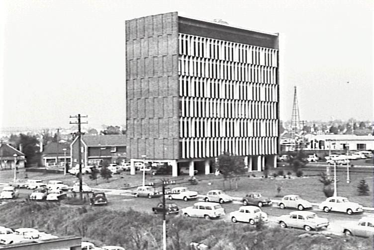
The Campbelltown Council office building is an outstanding example of a mid-century modernist high-rise office tower in the Macarthur region. Unfortunately the hopes and dreams of local decision makers who approved its construction were dashed in later decades.

Campbelltown Council offices 1967 CCL
View of Campbelltown Council administration building from Campbelltown Railway Station in 1967 showing its prominence in the town centre. (CCL)


A metaphor for a community on the move

The new administration building was a metaphor for Campbelltown’s growing confidence in the 1960s and the town’s future.

The building symbolised the hopes and dreams of planners and administrators and the immense changes that were to engulf Campbelltown over the following decades.

At the official opening on 28 November, 1964 Campbelltown Mayor TK Fraser felt that the town was on the verge of something special. He said,

At the threshold of the most dynamic period in the history of its area, Campbelltown Municipal Council, imbued with a strong sense of purpose and complete confidence in the future, has provided this imposing Administrative Building’.

The building, the first stage of a Civic Centre which will cater for the needs of a rapidly expanding community, stands as a practical demonstration of the confidence with which Council faces the future convinced that this area, steeped in history, at present of unsurpassed rural charm, will develop, in the near future, into a thriving Satellite City. (Official programme)

Campbelltown Council Chambers 1960s Geoff Eves
A view of the moderne Campbelltown Council administration building in the mid-1960s which was officially opened in 1964. This image was taken by local Campbelltown photographer Geoff Eves and shows the clean lines and minimalist style. (G Eves)


The administration building was developed under the guidelines of the County of Cumberland Scheme. It was part of an existing Campbelltown civic precinct that included the ambulance station and courthouse, and adjacent to the police station and railway station.

Alderman Percival, the vice-chair of the council Civic Centre committee, maintained that the building’s design catered for the anticipated administration by the council as a satellite city. The status of a satellite city was part of the proposed decentralisation by the County of Cumberland with Campbelltown’s projected population to grow to 200,000.  (Construction, 11 September 1963)

Planning for the new office building had begun in 1961 when the school of arts building provided inadequate to accommodate council staff. Initially housed in the old town hall council staff had moved out into the school of arts after the 1948 amalgamation with Ingleburn Municipal Council.

‘The move into the new 1964 building was not without criticism’, said Alderman Percival. He argued that the council’s progression with the project was a ‘considerable moment’ for the municipality.

He said, ‘It was a necessary demonstration of confidence in the municipality by Council’. (Campbelltown Ingleburn News, 1 December 1964)

The architects agreed and said that the size, height and position of the building emphasised ‘the importance and dignity of Local Government function in the affairs of the city’. The two-storey atrium in the vestibule added greater emphasis to the building’s importance because of its aesthetic features including ‘sculptured central column, cascades and pool’. (Construction, 11 September 1963)


Campbelltown’s future assured says Deputy Premier at official opening

The New South Wales Minister for Local Government and Deputy Premier PD Hills officially opened the building on 28 November 1964.

Minister Hills re-assured the council that the state government was about to make Campbelltown a self-contained satellite city beyond the Green Belt of the Cumberland Plan.

Mr Hills said, ‘Campbelltown is a thriving urban centre set in rural surroundings, but so close to Sydney metropolis that it largely acts as a dormitory-area for a workforce which finds its employment in the metropolitan area’.

‘It will be necessary to create accommodation within or close to the County of Cumberland, but outside the Green Belt, for an additional 300,000 people every eight years’, he said.

‘This means that we must have beyond the Green Belt but within 30 to 50 of Sydney a series of satellites which will be self-contained in the local sense but yet regionally associated with the metropolis’.

The minister said, ‘In the selection of sites for such development, the Campbelltown area is an obvious choice’. (Campbelltown-Ingleburn News, 1 December 1964)

Campbelltown Plaque Commemorating Opening Campbelltown Council Office 1964 H Neville 2020 lowres
Campbelltown Council Office Building foundation stone 29 February 1964 (H Neville 2020)


Storm clouds gather of the planning horizon

The decision by Campbelltown Municipal Council to build the new office accommodation was based on the direction and security provided by the state government’s County of Cumberland plan.

Unfortunately for the council, the New South Wales had abolished the County of Cumberland in December 1963 twelve months before the opening of the new building.

The state government had removed the security of the existing planning framework on which the council had initially been based its decision to proceed with the new building.

Yet the minister continued to re-assure Campbelltown Council of its position at the opening of the administration building in November 1964. (Campbelltown-Ingleburn New, 1 December 1964)

The New South Wales state government’s  State Planning Authority Act 1963. replaced the County of Cumberland with The State Planning Authority (SPA)  in December 1963. The SPA explicitly abandoned the Cumberland scheme’s green belt and satellite cities and devised a Sydney Region Outline Plan 1970–2000 A.D.

The state government proceeded with the development of the 1968 Sydney Region Outline Plan and then followed up with the  1973 New Cities Structure Plan Campbelltown, Camden and Appin.

The New Cities of Campbelltown Camden Appin Structure Plan 1973 prepared by The State Planning Authority of New South Wales as part of the 1968 Sydney Region Outline Plan.

The rosy future of Campbelltown spoken about by the minister and the mayor was not quite as secure as they might have presented it to the community.

Upbeat statements by the mayor and minister encapsulated the elements that eventually foreshadowed dark clouds gathering on the Campbelltown planning horizon.

In the end the storm clouds that gathered around the planning processes rained down on the Campbelltown area in the late 1970s and early 1980s, creating much angst for many in the community.


An important local icon

While the contested nature of the planning regime gave many in Campbelltown severe heartburn in the late 1970s and early 1980s, the city was left with an iconic mid-century moderne marvel.

Designed by Sydney architects Davey, Brindley and Vickery in an Internationalist style the office building is a rare intact example in the area of this type of architecture in the local area.

Campbelltown Council office 1966 CIPP
A view of Campbelltown Council administration building from Campbelltown Railway Station in 1966 (CCL)

The building retains much of its 1964 integrity with its clean lines and minimalist non-maintenance finish and functional design with the use of concrete, brick, glass and aluminium materials.

The office building is an essential marker of  mid-20th century Campbelltown and a statement of intent by a council that felt that the town had a secure future as a Sydney satellite city.


A moderne architectural gem

Sydney architects Davey, Brindley and Vickery stated that the ‘sharp vertical lines’ of eight-storey building had a steel-encased frame and was built on piles with reinforced concrete floors connected by two high-speed lifts.

The International modernist design style had steel, glass and mass-produced materials as the main characteristic. The rooms had the full expanse of the width of the building with its clean lines supported by dull and shiny surfaces. (Campbelltown Ingleburn News, 1 December 1964)

Campbelltown Council Admin Bldg Op Mtg Rm1982Sept16 Cover_0001
An image of the Campbelltown Council Administration Building from official programme given to dignataries at the opening in November 1964 (CMC)


A feature of the building was the entrance vestibule with a two-storey open atrium, which contained a floating stairway over an indoor garden. On the east side of the vestibule was a cast bronze multiplane historical mural by Bim Hilder mounted on a high exposed aggregate wall. (Campbelltown Ingleburn News, 1 December 1964)

The north wall of the foyer was faced with black marble with contrasting white marble door jamb and scag-terrazzo floor. The architects noted that the two primary colours were black and white, which compared with the red cedar-lined ceiling under the mezzanine level. (Campbelltown Ingleburn News, 1 December 1964)

The stairs to the first level were black scag-terrazzo with a black anodised aluminium balustrade with clear glass panels. On the first floor, the panelled cedar walls contrasted with contrasting black and white colouring. (Campbelltown Ingleburn News, 1 December 1964)

The architects stated that the building was finished in non-maintenance materials. The exterior charcoal colouring of the building contrasts with a black anodised aluminium building. The sun-blades were heavy baked enamel with infill walls of dark brick. (Campbelltown Ingleburn News, 1 December 1964)

The 1964 International modernist building created quite a precedent in the small country town of Campbelltown, where the local community leaders were confidently predicting  a bright future.

Acknowledgements

I would like to thank the Local Studies Librarians at Campbelltown City Council Library for their assistance in the completion of this post.

1920s · 1973 New Cities Campbelltown Camden Appin Structure Plan · Aesthetics · Agriculture · Attachment to place · Belonging · British colonialism · Camden · Camden Council · Camden Story · Camden Town Centre · Cobbitty · Colonial Camden · Colonial frontier · Colonialism · Community identity · Cowpastures · Cultural Heritage · Cultural icon · Curtilage · Denbigh · Dharawal · Economy · Edwardian · England · Farming · Frontier violence · Georgian · Gothic · Governor Macquarie · Heritage · Historical consciousness · Historical Research · Historical thinking · History · Interwar · Landscape · Landscape aesthetics · Living History · Local History · Local Studies · Macarthur · Memory · Menangle · Modernism · Place making · Ruralism · Sense of place · Settler colonialism · Storytelling · Town planning · Urban growth · Urban Planning · Victorian

Hope, heritage and a sense of place – an English village in the Cowpastures

Camden Heritage Conservation Area

In 2006 Camden Council designated the Camden town centre as a  Heritage Conservation Area, and later incorporated it in the  2010 Local Environment Plan. A heritage conservation zoning, according to Camden Council, is :

 an area that has historic significance… [and]… in which historical origins and relationships between the various elements create a sense of place that is worth keeping.

Map Camden Town Centre HCA LEP 2010 CRAG
Map of the Camden Town Centre Heritage Conservation Area from 2010 Local Environment Plan. (Taken from 2016 Camden Residents Action Group Submission for State Listing)


Historic significance

Several writers have offered observations on Camden’s historical significance.

Historian Ken Cable argued in the 2004 Draft Heritage Report prepared by Sydney Architects Tropman and Tropman that: Camden town is a significant landmark in the LGA.  

In 2006 Sydney architect Hector Abrahams stated that Camden was ‘the best-preserved rural town in the entire Cumberland Plain’ (Camden Advertiser, 28 June 2006).

Hector Abrahams -best preserved- Camden Advertiser 2006 Jun28
Comment by architect Hector Abrahams that Camden was the best preserved country town rural town in the Cumberland Plain. Camden Advertiser 28 June 2006.


Historian Alan Atkinson has argued that Camden is ‘a profoundly important place’, while historian Grace Karskins maintains that ‘Camden is an astonishingly intact survival of early colonial Australia’.  


Sense of place

In the early 20th century poets, artists and writers waxed lyrical that the town was like ‘a little England’.

Camden Council documents stress the importance of rural nature of the town for the community’s sense of place and community identity.

Camden Aerial 1940 CIPP
An aerial view of Camden township in 1940 taken by a plane that took off at Camden airfield. St John’s Church is at the centre of the image (Camden Images)


This is quite a diverse range of views.

This blog post will look at the historical elements that have contributed to the town’s sense of place, and ultimately its historical significance.

While none of these elements is new, this is the first time they have been presented this way.


A private venture of Englishmen James and William Macarthur

The village was a private development of Englishmen James and William Macarthur on the family property of Camden Park Estate.

The Macarthur brothers had their private-venture village of Camden approved in 1835, the street plan drawn up (1836) and the first sale of land in 1841.  All within the limits of Camden Park Estate.

The Macarthur brothers had another private venture village at Taralga on Richlands and Menangle on Camden Park Estate.

Camden James Macarthur Belgenny
James Macarthur (Belgenny Farm)

Creation of a little English village

The notion of an English-style village on the family estate must have been an enticing possibility for the Macarthur brothers.

In the Camden village, James and William Macarthur named streets after themselves and their supporters. They include John Street, Macarthur Road, Elizabeth Street, Edward Street, Broughton Street, Exeter Street, Oxley Street, Mitchell Street. The Macarthur family and funded the construction of St John’s church on the hill and donated the surrounding curtilage.

St Johns Church
St Johns Church Camden around 1900 (Camden Images)

The Macarthur brothers created vistas from the family’s Georgian hilltop Georgian mansion across the Cowpastures countryside to their Gothic-style village church.

The Englishness of the Camden village entranced many visitors and locals, including artists and writers. On a visit in 1927, the Duchess of York claimed that the area was ‘like England.’


Strategic river crossing into the Cowpastures

The village was strategically located at the Nepean River ford where the first Europeans crossed the river. By the 1820s the river crossing was the main entry point to Macarthur brothers’ Camden Park Estate, the largest gentry property in the area.

The situation of the village on the Great South Road re-enforced the Macarthur brothers economic and social authority over the countryside.

The river crossing was one of the two northern entry points to their realm of Camden Park Estate, the other being at the Menangle.  Menangle later became another private estate village.

The Macarthur village of Camden would secure the northern entry to the family’s Camden Park estate where the Great South Road entered their property. By 1826 the river ford was the site of the first toll bridge in the area.

Camden Cowpastures Bridge 1842 Thomas Woore R.N. of Harrington Park CIPP


None of this was new as the river crossing had been the entry into the Cowpastures reserve declared by Governor King in 1803. The site was marked by the police hut in the government reserve at the end of the Cowpasture track from Prospect.


English place names, an act of dispossession

The Camden village was part of the British imperial practice of placing English names on the landscape. The name of the village is English as is the gentry estate within which it was located – Camden Park.

English place names were used in the area from 1796 when Governor Hunter names the site the Cow Pastures Plain. The Cowpastures was a common grazing land near a village.

Naming is a political act of possession, or dispossession, and is an active part of settler colonialism.

Camden Signage
The Camden sign on the entry to the town centre at Kirkham Reserve on Camden Valley Way formerly The Great South Road and Hume Highway. (I Willis)


The Cowpastures was a meeting ground in between the  Dharawal, the Dharug and the Gundungurra people. The area was variously known as ‘Baragil’ (Baragal)’ or Benkennie (dry land).

Indigenous names were generally suppressed by English placenames until recent decades.

Initially, the Wild Cattle of the Cowpastures that escaped from the Sydney colony in 1788 occupied the meadows of the Nepean River floodplain.

The Cowpastures became a contested site on the colonial frontier.


Dispossession in the English meadows of the Cowpastures

The foundation of the Macarthur private village venture was part of the British colonial settler project.

The first Europeans were driven by Britain’s imperial ambitions and the settler-colonial project and could see the economic possibilities of the countryside.

Under the aims of the colonial settler project, as outlined by Patrick Wolfe and later LeFevre, the new Europeans sought to replace the original population of the colonised territory with a new group of settlers.

Hunter’s naming of the Cowpastures was the first act of expropriation. Further dispossession occurred with the government reserve, and later Governor Macquarie created the government village of Cawdor in the centre of the Cowpastures.

Art Governor Macquarie SLNSW
Governor Macquarie SLNSW


The Europeans seized territory by grant and purchase and imposed more English place names in the countryside, and created a landscape that mirrored the familiarity of England.

The colonial settlers brought Enlightenment notions of progress in their search for some kind of utopia.


Cowpasture patriarchs

The Macarthur private venture village was located in a landscape of self-style English gentry, and their estates interspersed with several small villages.

The gentry estates and their homestead and farm complex were English style village communities. One of the earliest was Denbigh (1818).

denbigh-2015-iwillis
Denbigh Homestead Open Day 2015 IWillis


The oligarch-in-chief was Camden Park’s John Macarthur.

The Europeans used forced labour to impose English scientific farming methods on the country.

The Cowpasture colonial elite created a bunyip aristocracy and styled themselves on the English gentry.

On the left bank of the Nepean River were the gentry estates of Camden Park along with Brownlow Hill. On the right bank were the gentry properties of Macquarie Grove, Elderslie, Kirkham and Denbigh and several smallholders.

The ideal society for the colonial gentry included village communities. To foster their view of the world, the Europeans created the small village of Cobbitty around the Hassall family’s private Heber Chapel.

The village of Stonequarry was growing at the southern limits of the Cowpastures at the creek crossing on the Great South Road.  The village was located on the Antil’s Jarvisfield and later renamed Picton in the 1840s.

The picturesque Cowpastures countryside greeted the newly arrived Englishmen John Hawdon from County Durham. In 1828 Hawdon became the first person to put in writing that the Cowpastures area reminded him of the English countryside when he wrote a letter home.


The progress and development of the country town

The Enlightenment view of progress influenced the Macarthur’s vision for their Camden village. They sought to create an ideal village community of yeoman farmers and sponsored self-improvement community organisation including the School of Arts.

Camden School of Arts PReeves c1800s CIPP


Within the Macarthur fiefdom, former estate workers became townsmen, took up civic duties and ran successful businesses.

The village of Camden prospered, became a thriving market town and the economic hub of a growing district.

The architectural styles of the town centre shine a light on the progress and development of the Macarthur village. The architectural forms include  Georgian, Victorian, Edwardian, Interwar moderne, Mid-20th century modern, and Post-modern.

The town centre served a host of functions for the community that are indicated by the types of land use in a country town. These include commercial, government, open space, industrial, transport, residential, religious, agricultural, amongst others.


The country town idyll and the appearance of heritage

Since the 1973 New Cities Structure Plan for Appin, Campbelltown and Camden there has been increased interest in the cultural heritage of the town centre. This is the first appearance of the influence of post-modernism in the Camden story.

The New Cities Plan 1973[1]
The New Cities Structure Plan Campbelltown Camden Airds 1973
John Wrigley conducted the first heritage study of the Camden town centre in 1985 for the Camden Historical Society.

Urban growth and the loss of rural countryside has encouraged a nostalgic desire for the past. This process had led to the evolution of the Camden, the country town idyll.

The heritage of the town centre is what the community values from the past that exists in the present. It is made up of tangible and intangible heritage, as well as multi-layered and multi-dimensional. The town centre story can is a timeline with many side shoots or a tree with the main stem and many branches.


Camden time traveller and the town centre

The living history of the town centre is evident at every turn. At every corner. A visitor can be a time-traveller into the past. A view along the main street is a view into the past.

There are many locations in our local area where a person can be a time-traveller into the past. The traveller can be a participant in the area’s living history, ‘simply by being present’.

One of these sites is the commanding view from the hilltop at St John’s church. Here the traveller can view the Cowpasture countryside that nestles the Camden town centre within its grasp.

Cover  Pictorial History Camden District Ian Willis 2015
Front Cover of Ian Willis’s Pictorial History of Camden and District (Kingsclear, 2015)