1920s · Agricultural heritage · Agriculture · Agriculture history · Attachment to place · Belonging · Business · Business History · Camden · Camden Story · Cultural Heritage · Cultural plantings · Economy · Family history · Fergusons Australian Nurseries · Gardening · Heritage · History · Horticulture · Local History · Local Studies · Nepean River · Nursery · Place making · Placemaking · Plant Nursery · Retailing · rural-urban fringe · Sense of place · Storytelling · Sydney · Sydney's rural-urban fringe · The Great South Road · Uncategorized · Urban growth · Urban history · Urban Planning · urban sprawl · Urbanism

Ferguson’s Australian Nurseries on the urban fringe

Ferguson nurseries depart the urban fringe

The 20th-century story of Ferguson’s Australian Nurseries is about their location within Sydney’s rural-urban fringe.

Sydney’s urban fringe is a zone of transition that is constantly being shaped and re-shaped by the forces of urbanisation and a host of competing forces. (Willis 2014)

Plant nurseries arrive in the fringe, and competing forces eventually drive them from it after a time.

In this space, the Ferguson Australian Nurseries came and departed Sydney’s urban fringe as it moved with urban growth over the past 170 years. Shrewd business judgements ensured that the nurseries survived and thrived in this dynamic space and place.

Double Bay outlet

Ferguson’s nurseries arrived on Sydney’s fringe at Double Bay in the 1870s when Sydney was still a ‘walking city’. Horse trams, and later steam trams, started to appear in the city and travel out to Double Bay.

Double Bay was sparsely settled, and there was an array of colonial villas and mansions like Alexander Macleay’s colonial regency mansion Elizabeth Bay House (1839).

As Sydney grew in population, there were land sub-divisions from the 1840s. (Sheridan 2021) (SLNSW)

By the early 20th century, land values had risen with increased residential development   (Sheridan 2021). The land was more valuable for housing than a nursery, so economic forces gathered for its relocation.

By this time, Annie Henrietta Ferguson ran the nursery following the death of her husband, FJ Ferguson, aged 48 years, in 1899. Annie married FJ Ferguson in 1875.

Annie managed the Double Bay outlet until 1902, closed it by 1905 and moved the nursery to Hurstville. (WCL 2021)

F Ferguson’ & Son Australian Nurseries Trade Catalogue for 1930 (SLM)

Developments

Annie’s daughter, Margaret Elizabeth (Lizzie), born at Campbelltown in 1876, had married Alfred Denison (AD) Little at All Saints Woollahra in 1902. (WCL)

By 1903 Lizzie and AD Little had moved back to Camden from Double Bay with the birth of their son Sydney. AD Little was to play a leading role in the nursery’s management and became a partner in the business. (WCL 2021)

In 1902 the Sydney press reported a fire at the Camden Nursery that destroyed a packing shed full of equipment. The same report stated that AD Little was now one of the proprietors, the mayor of Camden (1904-1905) and a presiding magistrate. (Daily Telegraph, 15 August 1905)

The oldest nursery

The Camden News boasted in 1905 that Ferguson’s Australian Nurseries were the ‘oldest fruit nursery and garden in Australia’. (Camden News, 17 August 1905)

Hurstville nursery outlet

By 1904 the Double Bay Nursery had been relocated to Hurstville on Stoney Creek Road. (Morris and Britton 2000)

The Hurstville area was a sparsely populated farming area with the first land subdivision in the 1880s. By the early 20th century, the urban fringe of Sydney had reached the site, and there were a series of residential land releases. (SLNSW)

The Camden press reported in 1913 that Ferguson’s nurseries were being run by AD & FB Little, and land had been leased at Elderslie, where 150,000 grafted apple trees had been planted out. (Camden News, 7 August 1913)

In 1915 the business was managed by Fred Little. (Gosford Times and Wyong District Advocate, Friday 21 May 1915)

F Ferguson and Son Australian Nurseries Trade Catalogue for 1932 (SLM)

Nurseryman Eric Jurd recalls, ‘Fergusons grew open-ground stock at a site in Peakhurst’. Jurd believed that Ferguson’s had extensive land holdings in the Kingsgrove and Peakhurst. (McMaugh 2005: 251-253)

The New South Wales Government purchased the Hurstville nursery site to establish Kingsgrove High School on the corner of Kingsgrove Road and Stoney Creek Road in 1958. (SRNSW)

Continued expansion

The nursery continued to expand, and by 1915, a report in the Gosford press indicated that Fergusons were operating from four sites:

  • Hurstville – a 40-acre site which was a general nursery and despatching centre for sales
  • Camden – a 60-acre site mainly producing fruit trees
  • Gosford – a 40-acre site, a nursery for grape vines and fruit trees
  • Ronkana (Ourimbah) – a 100-acre site under preparation. (Gosford Times and Wyong District Advocate, Friday 21 May 1915)

In the early 1920s, there were extensive land releases in the Hurstville area, including the King’s Park Model Suburb of 600 lots adjacent to Ferguson’s Nursery on Stoney Creek Road. (St George Call (Kogarah) 22 September 1922) In 1926 the Simmons Estate next door to Ferguson’s Nursery was offered for sale. (St George Call (Kogarah) 5 February 1926)

By the interwar years, the Hurstville nursery site was a well-known landmark often referred to in the press. For example, a press report of Tooth’s Brewery’s purchase of a site at Bexley (Construction and Local Government Journal, 13 July 1927), and the NRMA used the nursery as a prominent and well-known landmark in their tourism promotion for road trips in and around the Sydney area. (Sun (Sydney) 18 November 1927).

The nursery business continued under the control of AD & FB Little until the 1930s, and they were followed by Arthur Bruce (AB) Ferguson (1889 -1949). (Little 1977)

Fruit trees and vines

Ferguson’s nurseries sold fruit trees and vines to new producers in the emerging horticulture areas throughout Australia and New Zealand.

Large quantities of grapevines had been supplied to the Yanco Irrigation Area in 1915. (Gosford Times and Wyong District Advocate, Friday 21 May 1915)

In 1926 an article in the Leeton press mentioned that Fergusons Nurseries had fruit trees for sale. (Murrumbidgee Irrigator (Leeton, NSW: 1915 – 1954), Tuesday 16 February 1926)

As indicated by a story in the Tumut press, agents for the nursery were often keen to promote that stock of fruit trees, vines, and flowering plants were available for purchase. (Tumut and Adelong Times, 28 May 1929)

Water supply

A reliable water supply is essential for horticulture and the nursery industry.

In 1922 an irrigation licence was issued to Alfred D (AD) Little, a partner for Ferguson & Sons, Australian Nursery, Camden, to pump up to 150 gallons per minute on the right bank [Elderslie]. (NSW Government Gazette, 11 August 1922)

The next generation

In 1927 FB Little died at Hurstville, and in 1933 AD Little died at Camden and is buried in St John’s Cemetery.

In 1932 the Australian Nursery site on the Nepean River, known as The Nursery or the Camden Nursery, part ownership passed to Stanley Nigel (SN) Ferguson. (Sanders 2008b) After World War II, SN Ferguson’s son, Bruce (1916 – 2008), inherited a half-share in The Nursery site. (Sanders 2008a)

In 1935 Ferguson’s nursery purchased land owned by Mr W Moore between the Old South Road and the Hume Highway. (Camden News, 11 April 1935)

Following this period, the Camden nursery moved to Broughton & Little Street  (Nixon 1989) at the rear of the Camden District Hospital until the business was sold in the mid-1960s. (Nixon 1991)

References

Little, S. F. (1977). Correspondence to CHS 17 February 1977. Ferguson File, Camden Museum Archive.

Morris, C. and G. Britton (2000). Colonial landscapes of the Cumberland Plain and Camden, NSW: A survey of selected pre-1860 cultural landscapes from Wollondilly to Hawkesbury LGAs. Sydney NSW, National Trust of Australia (NSW). 1 & 2.

Nixon, R. E. (1989). File notes for correspondence to CHS from Helen R Dick 18 July 1989, Camden Museum Archives.

Nixon, R. E. (1991). The Rose Festival. Rose Festival File, Camden Museum Archives.

Sanders, G. J. (2008a). Distinguished in war and peace, Bruce Ferguson, Obituary 31 May. Sydney Morning Herald. 31 May 2008.

Sanders, G. J. (2008b). Eulogy for Bruce Ferguson. Ferguson File, Camden Museum Archives.

Sheridan, P. (2021). Sydney Art Deco and Modernist Walks Potts Point and Elizabeth Bay. Sydney, Bakelite and Peter Sheridan.

WCL (2021). “Double Bay as a nineteenth-century centre of gardening and horticulture.” Woollahra Local History/Woollahra’s Historic Landscapes. Retrieved 10 December 2021, 2021, from https://www.woollahra.nsw.gov.au/library/local_history/woollahras-historic-landscapes/horticulture-in-double-bay.

Willis, I. (2014). “Townies Exurbanites and Aesthetics: Issues of identity on Sydney’s rural-urban fringe.” AQ, Australian Quarterly(April-June 2012): 20-25.

Updated 23 May 2023. Originally posted 5 January 2022.

1920s · Argyle Street · Artefacts · Attachment to place · Camden · Camden Story · Collective Memory · Cultural Heritage · Engineering Heritage · Engineering History · Heritage · Highways · History · Hume Highway · Infrastructure · Living History · Local History · Local Studies · Memorial · Memorials · Memory · Mileposts · Monuments · Place making · Public art · Re-enactments · Roads · Service utilities · Storytelling · Technology · The Great South Road · Tourism · Transport · transport history · Travel · Travellers · Utilities · Wayfinding

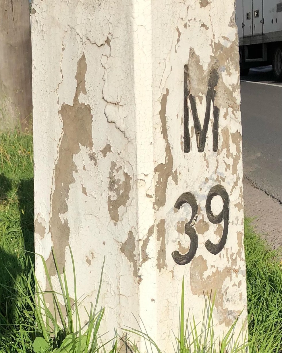
Mileposts captured the distance of the past

Camden Mileposts

On the Camden Town Centre edges are two white concrete posts with numbers and letters. What are they, and what do the letters mean?

These white concrete posts are mileposts from when the Hume Highway ran up the centre of Camden along Argyle Street. The letters indicate destinations and the numbers are distance in miles. These items are part of Camden’s engineering heritage.

A concrete milepost on the southern end of the Camden Town Centre on the road verge of the former Hume Highway, now the Old Hume Highway. (I Willis, 2021)

The letters: M is Mittagong, S is Sydney, L is Liverpool, and C is Camden. The distance is a mile:  an imperial unit of measure from before the time of metric measurement. The mile here is a statute mile which is 5280 feet or 1.609 km, as opposed to a nautical mile used in air and sea transport and is different.

The English mile

Mileposts dated back to the Roman Empire and were placed alongside the Roman roads. Distances were measured from the city of Rome. The mile originated from the Roman mille passus, or “thousand paces,” which measured 5,000 Roman feet.

The first mileposts along English roads appeared in 1593 and were standardised in England under the reign of Elizabeth I. The English mile was a different length from the Scottish mile and the Irish mile.  These measures were not standardised in the British Commonwealth and the US until 1959. (Sydney Morning Herald, 22 August 1935. https://www.britannica.com/science/mile)

In the colony of New South Wales, the first sandstone milestones were located on the Parramatta, Liverpool and South Head Roads from 1816 on the instructions of Governor Macquarie. Milestones provided accurate reference marks along with the expanding public road system for travellers on coaches. (Crofts and Crofts, 2013)

Macquarie Obelisk

In the colonial period, Governor Macquarie’s Obelisk of Distances was erected in 1818 as the official starting point for all distances in NSW. It was located in what was then the centre of Sydney and is now Macquarie Place. The monument was also ‘a symbolic peg’ as the furthest extent of the British Empire in the early 1800s.

Obelisk of Distances in Macquarie Place Sydney was designed by Francis Greenway and built-in 1818 under the orders of Governor Macquarie c1926 (SLNSW)

The placement of milestones in colonial NSW set a precedent. They were placed along the left-hand or southern side of the roadway, with the destination facing Sydney. The posts were meant to be seen by travellers coming from either direction to measure their distance from Sydney for the benefit of stagecoach drivers. They also ensured the driver was on the correct road, as many were bush tracks. (Crofts and Crofts, 2013)

Concrete mileposts

The two concrete mileposts in Camden were part of the road improvements by the NSW Department of Main Roads in 1934.

The decision to implement a programme of mileposting followed the first annual conference of state road authorities in February 1934 held in Melbourne. The meeting decided to adopt uniform national procedures for mileposting and road warning signs for roadworks, among other matters. It was felt that uniformity of services would help interstate travellers. (DMR, 1934)

A concrete milepost on the northern entry to the Camden Town Centre on the roadside verge of the former Hume Highway ran along Argyle Street Camden. (I Willis, 2021)

In 1934 the department allocated £134 to the program in the Sydney area. (DMR, 1934)

The DMR Main Roads magazine stated that

According to the Department of Main Roads, mileposting before 1934 provided signs that gave directions and the distance of important towns. Mileposts had lost their importance to the traveller because the car speedometer gave ‘progressive mileage’ stated a departmental report. (DMR, 1934a)

Road maintenance

Mileposting in 1934 was implemented with one specific aim.

The stated purpose was for the milepost to be a reference point along the road to give a precise position for any roadwork needed. Information to travellers was only secondary. (DMR, 1934a)

Mileposting to 1934 had been haphazard, with much work generated at a  local level and many gaps. Road maintenance was a secondary consideration, with information for travellers paramount. Much work was ‘incomplete’. Groups of mileposts were only based around important towns, sometimes following main roads and sometimes not. (DMR, 1934a)

The 1934 mileposting project was partly triggered by the 1928 classification of all roads in NSW into state highways, trunk roads and ordinary roads.

The 1928 changes saw The Great Southern Road through Camden renamed the Hume Highway in 1928. The 1929 Razorback Deviation shifted the highway to the east, away from the former Great South Road (now Cawdor Road). (DMR, 1934a)

Different types of mileposts were used in 1934 for different purposes.  Concrete posts were used in Sydney and country towns like Camden, and timber posts were used elsewhere.

Specifications and drawings for mileposts as outlined in the Department of Main Roads journal Main Roads (May 1934), where the DMR mileposting project was detailed for all roads in NSW (Main Roads 1934a)

There was a strict protocol for the letters and numbers on the posts, with letters and numbers incised and painted black and distances measured from the post office, sometimes not.  Posts were placed on the left-hand side of roadways leading from Sydney or the coast, as they were in colonial times.

Posts were located with a clear view from the roadway of 200 feet with specific instructions on distances from roadways and locations for cuttings and embankments. On bridges, the mileposts were clamped to the handrails.

In mid-1934, the NRMA suggested the mileposts on the different highways should be painted in various colours. (Kiama Reporter and Illawarra Journal, 20 June 1934) The suggestion was not taken up.

One supplier of the concrete mileposts was the Hume Pipe Coy (Aust) Ltd. (Main Roads, August 1938)

Wooden Mileposts

In the Camden area, the Camden Heritage Inventory states there were wooden mileposts along Cawdor Road, formerly The Great South Road. They pre-date the concrete mileposts.

Timber milepost c1927 on the verge of The Great South Road, now Cawdor Road. (2021 I Willis)

In a 2002 survey for the Heritage Inventory, the three Cawdor Road timber mileposts were intact.

The posts were local hardwood cut by a sawmill in Edward Street in the late 1920s and delivered to The Great South Road (Cawdor Road) site by Camden teamster Les Nixon. (NSWSHI)

In a recent search, I could only locate one intact timber milepost in fairly poor condition.

This timber milepost c.1929-1934 is located on the former Hume Highway at South Camden, now Remembrance Drive. This milepost is located on the 1929 Hume Highway Razorback deviation that moved the main road from the Great South Road, now Cawdor Road. (I Willis, 2021)

This timber milepost c.1929-1934 is located on the former Hume Highway at South Camden, now Remembrance Drive. This milepost is not on the Wollondilly Shire Council heritage inventory. The milepost is on the roadside verge adjacent to the Camden Valley Inn. (I Willis, 2021)

References

CROFTS, R. & CROFTS, S. 2013. Discovering Australia’s Historical Milemarkers and Boundary Stones, Sydney, Roberts and Sandra Crofts.

DMR 1934. Department of Main Roads Ninth Annual Report for the year ending 30th June 1934. Sydney: NSW Legislative Assembly.

DMR 1934a. The Mileposting on Main Roads. Main Roads, 5.

Updated on 15 August 2023. Originally posted on 13 November 2021 as ‘Capturing the distance of the past’.