Attachment to place · Belonging · Blue Plaques · Camden Red Cross · Camden Story · Cultural Heritage · Cultural icon · First World War · Historical consciousness · History · Local History · Local Studies · Memorial · Memory · Military history · Myths · Philanthropy · Pioneers · Place making · Red Cross · Second World War · Sense of place · Storytelling · Volunteering · Volunteerism · War · War at home · Wartime · Women's history · World War One

Blue Plaque recognises Camden Red Cross sewing circle in wartime

Camden Red Cross sewing circles during the First and Second World Wars

The wartime efforts of Camden women have been officially recognised for the first time by the successful nomination for a New South Wales Blue Plaque with Heritage NSW. Camden Red Cross women volunteers thousands of hours of their time and skill to provide requisites for military hospitals for wounded Australian soldiers.

The announcement appeared in the Sydney press with 17 other successful nominations for a Blue Plaque across the state. They include notable people and events in their local area.

The Blue Plaque on the front of the former Camden Town Hall. The plaque celebrates and remembers the service of the Camden Red Cross sewing circles women who donated thousands of hours of their effort and skills to supply hospital requisites for the soldiers and military hospitals in the First and Second World Wars. (I Willis, 2023)

What is being recognised?

The Blue Plaque officially recognised for the first time the Camden Red Cross patriotic wartime sewing circles at the Camden School of Arts (later the Camden Town Hall, now the Camden Library) – 1914-1918, 1940-1946. This is the only recognition of this type of Red Cross wartime activity anywhere in Australia.

The Sidman women volunteer their time and effort during the First World War for the Camden Red Cross. Patriotic fundraising supporting the war at home was significant, raising thousands of pounds. This type of effort was quite in all communities across Australia and the rest of the British Empire. (Camden Images and Camden Museum)

The story of the Camden Red Cross sewing circles

The Camden Red Cross sewing circles were one of Camden women’s most important voluntary patriotic activities during World War One and World War Two. The sewing circles started at the Camden School of Arts in 1914 and, due to lack of space, moved to the Foresters’ Hall on Argyle Street in 1918. At the outbreak of the Second World War, sewing circles reconvened in 1940 at the Camden Town Hall on John Street (the old School of Arts building – the same site as the First World War)

These sewing circles were workshops where Camden women volunteered and manufactured supplies for Australian military hospitals, field hospitals and casualty clearing stations. They were held weekly on Tuesdays, sale days in the Camden district.

Sewing circles were ‘quasi-industrial production lines’ where Camden women implemented their domestic skills to aid the war at home. Camden women cut out, assembled, and sewed together hospital supplies, including flannel shirts, bed shirts, pyjamas, slippers, underpants, feather pillows, bed linen, handkerchiefs, and kit bags. The workshops were lent several sewing machines in both wars.

The sewing circles also coordinated knitting and spinning for bed socks, stump socks, mufflers, balaclava caps, mittens, and cholera belts (body binders). The women also made ‘hussifs’ or sewing kits for the soldiers.  The sewing circles attracted 80-100 women weekly during the First World War. The list of items was strikingly consistent for hospital supplies for both wars, with the only significant addition during the Second World War being the knitted pullovers and cardigans.

The production output of the Camden women was prodigious. Between 1914 and 1918, Camden Red Cross sewing circle women made over 20,300 articles tallied to over 40,000 volunteer hours.  Between 1940 and 1946, during World War Two, women made over 25,000 articles, totalling over 45,000 voluntary hours.

The operation of the sewing circles was fully funded through the fundraising of Camden Red Cross and community donations.  In 1917 alone, over 95% of branch fundraising was dedicated to these activities.

In World War One, other Red Cross sewing circles in the Camden district were at The Oaks, Camden Park, Theresa Park, and Middle Burragorang. During World War Two, other centres across the local area included Bringelly-Rossmore, Menangle, Narellan, and The Oaks. Each group independently funded its activities.

These patriotic voluntary activities by Camden women were part of the war at home and have received little recognition at a local, state or national level. Wartime sewing and knitting have been kept in the shadows for too long. There needs to be a public acknowledgement of the patriotic effort of these women.

The placement of the plaque

The Blue Plaque was installed on the front of the Camden Library building in 2022 at 40 John Street Camden. This building was formerly the Camden Town Hall and the Camden School of Arts. The women of the Camden Red Cross used the town hall as the centre of their sewing effort in the First and Second World Wars to supply hospital requisites for soldiers and military hospitals. (I Willis, 2023)

The Blue Plaque was placed on the front of the former Camden School of Arts – later called the Camden Town Hall (1939-1945),then converted to offices in 1964 and now the Camden Library.

Camden School of Arts from 1866 to 1963 (PReeves/Camden Images)

Camden Museum Library building in John Street Camden, where the Blue Plaque will be located, recognising the efforts of the Camden Red Cross sewing circles in both World War One and World War Two. (I Willis, 2008)

Official recognition is long overdue

The official recognition of the wartime effort and skills of Camden women using their domestic arts and crafts in the patriotic service of Australia has taken over 75 years. This small acknowledgement of the wartime service of the Camden Red tells the story of ordinary women in extraordinary circumstances and has been long overdue.

Acknowledgement by the Member for Camden Peter Sidgreaves MP

This is an article from the newsletter from Peter Sidgreaves MP Member for Camden, where he has given official acknowledgement of the wartime patriotic service of Camden Red Cross women (Newsletter November 2022, Issue 14)

What is a Blue Plaque?

The Heritage NSW website states:

The Blue Plaques program aims to capture public interest and fascination in people, events and places that are important to the stories of NSW.

The Blue Plaques program celebrates NSW heritage by recognising noteworthy people and events from our state’s history.

The aim of the program is to encourage people to explore their neighbourhood and other parts of NSW and connect with people of the past, historical moments and rich stories that matter to communities and have shaped our state.

The program is inspired by the famous London Blue Plaques program run by English Heritage which originally started in 1866, and similar programs around the world.

“Behind every plaque, there is a story.”

The essence of the Blue Plaques program is the storytelling. A digital story will be linked to each plaque.

The Blue Plaques should tell stories that are interesting, fun, quirky along with more sombre stories that should be not be forgotten as part of our history.

English Heritage and Blue Plaques in the United Kingdom

The New South Wales Blue Plaques were based on the English model, and the English Heritage website states:

London’s blue plaques scheme, run by English Heritage, celebrates the links between notable figures of the past and the buildings in which they lived and worked. Founded in 1866, it has inspired many similar schemes in the UK and around the world.

Camden Red Cross Blue Plaque installation

Dr Ian Willis organised the paperwork through the office of the local Member for Camden Peter Sidgreaves MP, for the installation of the Blue Plaque. The competitive process meant only around 17 sites were chosen for plaques from around 70 applications across New South Wales for this round. The installation occurred on 14 October 2022. (I Willis, 2022)

Reference

Ian Willis, Ministering Angels, The Camden District Red Cross 1914-1945. Camden Historical Society, Camden, 2014.

Updated 24 April 2023. Originally posted 18 April 2022.

1968 Sydney Region Outline Plan · 1973 New Cities Campbelltown Camden Appin Structure Plan · Advertising · Attachment to place · Built heritag · Community identity · Cultural Heritage · Elderslie · Heritage · History · Land releases · Living History · Local History · Local Studies · Place making · rural-urban fringe · Storytelling · Uncategorized · Urban development · Urban growth · Urban history · Urban Planning · urban sprawl · Urbanism

Elderslie land releases 2000-2023, the background and fancy estate names

Elderslie part of Sydney’s strategic growth

The Elderslie area has been identified in Sydney’s strategic growth plans for land releases on the metropolitan rural-urban fringe. It is a valuable exercise to see how and when Elderslie was identified as part of Sydney’s planning framework.

Elderslie was not part of the NSW Government’s first attempt at town planning with the 1948 County of Cumberland Planning Scheme. A greenbelt surrounded the metropolitan area, and Elderslie was beyond it and not destined for the development. The scheme was prescriptive and met with significant opposition, including local government and the development industry, and the scheme was dissolved in 1963.

The County of Cumberland Planning Scheme flyer 1948 (City of Syd Archives)

The Elderslie area was included in the next planning iteration with the Askin Government’s 1968 Sydney region: Outline plan 1970-2000 A.D.: a strategy for development. This plan led to the 1973 New Cities of Campbelltown Camden Structure Plan and the Commonwealth Government’s Macarthur Growth Centre. This plan offered flexibility and changes and turned into a developer’s dream. Sydney’s urban sprawl continued to spread, and nothing much eventuated at Elderslie. (Ashton & Freestone 2008)

The first hint of real change at Elderslie occurred with the third strategic plan: the 1988 Sydney into its third century: a metropolitan strategy for the Sydney region. This plan envisaged that Sydney’s growth would be contained in newly developing areas along the transport routes: Northwest, Southwest, Bringelly and Central Coast, with higher densities to consolidate Sydney’s growth. (SRANSW 1995) These plans resulted in suburbia encroaching on the boundaries of Elderslie with the development of Mount Annan, Narellan Vale, Harrington Park and surrounding suburbs.

Air pollution and water quality issues in the Hawkesbury-Nepean catchment further postponed the rezoning of land in the Elderslie area beyond 1990. (BBC Consulting) Meanwhile, another new metropolitan plan appeared in 1995, Cities for the 21st Century.

The Elderslie Urban Release Area was identified by the Department of Urban Affairs and Planning in 1995 under the 1980 Urban Development Program managed by the department. (BBC Consulting 1998) At the time, the department was looking for opportunities to drive Sydney’s urban growth (SRANSW 1995) and the identification and coordination of new residential land. (BBC Consulting 1998)  The Elderslie Release Area consisted of 180 hectares, and it was envisaged that the area might yield 2800 lots, which was revised down to 1700 lots. (BBC Consulting 1998)

Sydney’s strategic planning was further updated with the 1998 Shaping Our Cities. This plan called for higher densities with familiar themes of better integration of land use and transport and promotion of suburban activity centres with a more explicit concern with urban design at a regional scale. (Ashton & Freestone 2008)

In 2000 the state government identified the Elderslie Urban Release Area for redevelopment under  NSW Urban Development Program. The Elderslie area was zoned rural then, with a minimum subdivision of 40 ha. (Godden, Mackay and Logan 2001)

An article from the Camden press about the Elderslie Urban Land Release in 2000 by the NSW Government (The District Reporter, 3 November 2000)

The 180 ha. Elderslie Release Area was developed as part of the Camden Local Environmental Plan No 117 when it was put on public display in 2000 to replace the Camden LEP No 46. The LEP described the desired character of the area in a list of planning controls and was legislated in 2004. (Godden, Mackay and Logan 2001)

Elderslie was within the South West Growth Centre as part of the 2005 City of Cities: a plan for Sydney’s future metropolitan strategy of the state government. The plan reflected familiar urban planning themes of the end of sprawl with a more compact city, higher densities, sub-regional centred, transport integration and urban design. (Ashton & Freestone 2008)

Elderslie land releases

The names given Elderslie land releases range from the commodification of the rural aesthetic of the local area to a  locality name, names of local identities or hints of the historical past.

1999 Elderslie

The Elderslie land release in 1999 (Macarthur Advertiser, 25 August 1999)

2000-2014 Elderslie Masterplan and community meetings

2004-2007 Camden Acres

The cover of the Camden Acres land release in 2004 (Camden Acres)

2005-2014 The Ridges

A flyer from the developer of The Ridges land release in 2006 (The Ridges AV Jennings)

2007-2014  Vantage Point

2008-2009  Camden Hillside

2009  Mount View Estate

2010 Elderslie Estate

2010-2012  Hillcrest

2011-2013  Merino

2012-2013  Camden Heights

2013  Studley Park

2016  Franzman Ave

2017 Lodges Road

2017-2023 Argyle

Screenshot of The Argyle land release in 2023 (The Argyle)

References

BBC Consulting 1998, Elderslie Open Space and Social Plan. Camden Council, Camden.

State Records Authority of NSW 1995, Department of Environment and Planning (1980- 1988) Department of Planning [I](1988-1995). Online at https://researchdata.edu.au/department-environment-planning-i1988-1995/164536 Viewed 18 April 2023.

Ashton, Paul, Freestone, Robert, Planning, Dictionary of Sydney, 2008, http://dictionaryofsydney.org/entry/planning, viewed 18 Apr 2023

Godden, Mackay and Logan 2001, Elderslie Urban Release Area Heritage Assessment. Camden Council, Camden.

British colonialism · Camden · Camden District · Cawdor · Cobbitty · Colonial Camden · Colonialism · Community identity · Convicts · Cowpastures · England · Farming · Floods · Heritage · Historical consciousness · Historical Research · History · Landscape aesthetics · Local History · Macarthur · Menangle · Myths · Parks · Place making · Regionalism · Royal Tours · rural-urban fringe · Sense of place · Settler colonialism · Tourism · Transport · Urban growth · Urban history · Urbanism · Volunteering

The Camden district, 1840-1973, a field of dreams

A colonial region

It is hard to imagine now, but in days gone by, the township of Camden was the centre of a large district. The Camden district became the centre of people’s daily lives for over a century and the basis of their sense of place and community identity.

The Camden district was a concept created by the links between peoples’ social, economic and cultural lives across the area. All are joined together by a shared cultural identity and cultural heritage based on common traditions, commemorations, celebrations and rituals. These were reinforced by personal contact and family kinship networks. The geographers would call this a functional region.

Map Camden District 1939[2]
Map of the Camden district in 1939 showing the extent of the area with Camden in the east. The silver mining centre of Yerranderie is in the west. (I Willis, 1996)

The Camden district ran from the Main Southern Railway around the estate village of Menangle into the gorges of the Burragorang Valley in the west. The southern boundary was the Razorback Ridge, and in the north, it faded out at Bringelly and Leppington.

The district grew to about 1200 square kilometres with a population of more than 5000 by the 1930s through farming and mining.  Farming started with cereal cropping and sheep, which turned to dairying and mixed farming by the end of the 19th century. Silver mining started in the late 1890s in the Burragorang Valley, and coal mining from the 1930s.

burragorang-valley Sydney Water
Burragorang Valley (Sydneywater)

The district was centred on Camden, and there were several villages, including Cobbitty, Narellan, The Oaks, Oakdale, Yerranderie, Mt Hunter, Orangeville and Bringelly.  The region comprised four local government areas – Camden Municipal Council, Wollondilly Shire Council, the southern end of Nepean Shire and the south-western edge of Campbelltown Municipality.

Cows and more

Before the Camden district was even an idea, the area was the home of ancient Aboriginal culture based on Dreamtime stories. The land of the Dharawal, Gundangara and the Dharug.

The Europeans turned up in their sailing ships. They brought new technologies, new ideas and new ways of doing things. The First Fleet cows did not think much of their new home in Sydney. They escaped and found heaven on the Indigenous-managed pastures of the Nepean River floodplain.

1932_SMH_CowpastureCattle_map
Map of Cowpastures SMH 13 August 1932

On discovering the cows, an inquisitive Governor Hunter visited the area and called it the Cow Pasture Plains. The Europeans seized the territory, allocated land grants, and displaced the Indigenous occupants.  They created new land in their own vision of the world.  A countryside comprised of large pseudo-English-style estates, an English-style common called The Cowpasture Reserve and English government men to work it called convicts. The foundations of the Camden district were set.

A river

The Nepean River was at the centre of the Cowpastures and the gatekeeper for the wild cattle.  The Nepean River, which has an Aboriginal name of Yandha, was named by Governor Arthur Phillip in 1789 in honour of Evan Nepean, a British politician.

The Nepean River rises in the ancient sandstone country west of the Illawarra Escarpment and Mittagong Range around Robertson. The shallow V-shaped valleys were ideal locations for the Upper Nepean Scheme dams built on the tributaries to the Nepean, the Cordeaux, Avon, and Cataract.

View upon the Nepean River, at the Cow Pastures New South Wales Drawn and engraved by Joseph Lycett from his Views of Australia 1824-1825 (SLV)

The river’s catchment drains northerly and cuts through deep gorges in the  Douglas Park area. It then emerges out of the sandstone country and onto the floodplain around the village of Menangle. The river continues in a northerly direction downstream to Camden, then Cobbitty, before re-entering the sandstone gorge country around Bents Basin, west of Bringelly.

The river floodplain and the surrounding hills provided ideal conditions for the woodland of ironbarks, grey box, wattles and a ground cover of native grasses and herbs.  The woodland ecology loved the clays of Wianamatta shales that are generally away from the floodplain.

The ever-changing mood of the river has shaped the local landscape.  People forget that the river could be an angry, raging, flooded torrent on a destructive course. Flooding shaped the settlement pattern in the eastern part of the district.

Camden Airfield 1943 Flood Macquarie Grove168 [2]
The RAAF Base Camden was located on the Nepean River floodplain. One of the hazards was flooding, as shown here in 1943. The town of Camden is shown on the far side of the flooded river. (Camden Museum)

A village is born

The river ford at the Nepean River crossing provided the location of the new village of Camden established by the Macarthur brothers, James and William. They planned the settlement on their estate of Camden Park in the 1830s and sold the first township lots in 1840. The village became the transport node for the district and developed into the area’s leading commercial and financial centre.

Camden St Johns Vista from Mac Pk 1910 Postcard Camden Images
Vista of St. Johns Church from the Nepean River Floodplain 1910 Postcard (Camden Images)

Rural activity was concentrated in the new village of Camden. There were weekly livestock auctions, the annual agricultural show and the provision of a wide range of services. The town was the centre of law enforcement, health, education, communications and other services.

The voluntary community sector started under the direction of mentor James Macarthur. His family also determined the moral tone of the village by sponsoring local churches and endowing the villagers with parkland.

Camden Mac Park
Camden’s Macarthur Park was endowed to the residents of Camden by Sibella Macarthur Onslow in the early 20th century (I Willis, 2016)

Manufacturing had a presence with a milk factory, a timber mill and a tweed mill on Edward Street that burnt down.   Bakers and general merchants had customers as far away as the  Burragorang Valley, Picton and Leppington, and the town was the publishing centre for weekly newspapers.

Macarthur Bridge View from Nepean River Floodplain 2015 IWillis

The Hume Highway, formerly the Great South Road, ran through the town from the 1920s and brought the outside forces of modernism, consumerism, motoring, movies and the new-fangled-flying machines to the airfield.  This reinforced the market town’s centrality as the district’s commercial capital.

Burragorang Valley

In the district’s western extremities, the rugged mountains made up the picturesque Burragorang Valley. Its deep gorges carried the Coxes, Wollondilly and Warragamba Rivers.

Burragorang Valley Nattai Wollondilly River 1910 WHP
The majestic cliffs and Gothic beauty of the Burragorang Valley on the edges of the Wollondilly River in 1910 (WHP)

Access was always difficult from the time that the Europeans discovered its majestic beauty. The Jump Up at Nattai was infamous when Macquarie visited in 1815.  The valley became an economic driver of the district, supplying silver and coal hidden in the dark recesses of the gorges. The Gothic landscape attracted tourists who stayed in one of the many guesthouses to sup the valley’s hypnotic beauty.

Burragorang V BVHouse 1920s TOHS
Guesthouses were very popular with tourists to the Burragorang Valley before the valley was flooded after the construction of Warragamba Dam. Here showing Burragorang Valley House in the 1920s (The Oaks Historical Society)

The outside world was linked to the valley through the Camden railhead and the daily Camden mail coach from the 1890s. Later replaced by a mail car and bus.

Romancing the landscape

The district landscape was romanticised by writers, artists, poets and others over the decades. The area’s Englishness was first recognised in the 1820s.   The district was branded as a ‘Little England’ most famously during the 1927 visit of the Duchess of York when she compared the area to her home.

The valley was popular with writers. In the 1950s, one old timer, an original Burragoranger, Claude N Lee, wrote about the valley in ‘An Old-Timer at Burragorang Look-out’. He wrote:

Yes. this is a good lookout. mate,

What memories it recalls …

For all those miles of water.

Sure he doesn’t care a damn;

He sees the same old valley still,

Through eyes now moist and dim

The lovely fertile valley

That, for years, was home to him.

Camden John St (1)
St Johns Church at the top of John Street overlooking the village of Camden around 1895 C Kerry (Camden Images)

By the 1980s, the Sydney urban octopus had started to strangle the country town and some yearned for the old days. They created a  country town idyll.  In 2007 local singer song-writer Jessie Fairweather penned  ‘Still My Country Home’. She wrote:

When I wake up,

I find myself at ease,

As I walk outside I hear the birds,

They’re singing in the trees.

Any then maybe

Just another day

But to me I can’t have it any other way,

Cause no matter when I roam

I know that Camden’s still my country home.

The end of a district and the birth of a region

The seeds of the destruction of the Camden district were laid as early as the 1940s with the decision to flood the valley with the construction of the Warragamba Dam. The Camden railhead was closed in the early 1960s, and the Hume Highway moved out of the town centre in the early 1970s.

Macarthur regional tourist guide
Macarthur Regional Tourist Promotion by Camden and Campbelltown Councils

A new regionalism was born in the late 1940s with the creation of the federal electorate of  Macarthur, then strengthened by a new regional weekly newspaper, The Macarthur Advertiser, in the 1950s.   The government-sponsored and ill-fated Macarthur Growth Centre of the early 1970s aided regional growth and heralded the arrival of Sydney’s rural-urban fringe.

Today Macarthur regionalism is entrenched with government and business branding in an area defined by the Camden, Campbelltown and Wollondilly Local Government Areas.  The Camden district has become a distant memory, with remnants dotting the landscape and reminding us of the past.

Updated 14 July 2023. Originally posted 19 February 2018.

Aesthetics · Art · Artists · Belonging · Colonialism · Community identity · Community work · Crafts · Cultural Heritage · Design · Education · Elyard Reserve, Narellan · Heritage · History · Living History · Local History · Local Studies · Memorialisation · Memorials · Narellan · Parks · Place making · Public art · Sense of place · Settler colonialism · Settler Society · Storytelling · Tourism · Urban Planning · Urbanism

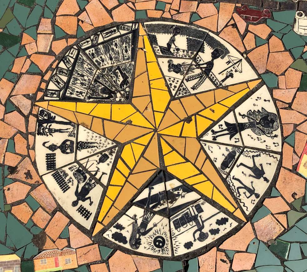
Narellan Community Mosaic Project: art in the park

Narellan Community Mosaic Project 2005

Walking from the Narellan Library carpark to Elyard Street along the paths next to the creek, you will pass one of Narellan’s public art installations – the Narellan Community Mosaic Project.

This image shows the extent of the Narellan Community Mosaic Project with its concentric rings of mosaic tiles creating a spectacle for the observer of the past and present in the Narellan area. (I Willis, 2023)

Public art installations in Narellan have received little attention and are hidden in plain sight. Other public art installations in the Narellan area include the Cowpastures Story, a mosaic bench, and a Goanna on the loose,

The Narellan Community Mosaic Project art installation is easy to miss as it blends in with the lawn and park landscape of Elyard Reserve. Maybe that was the intention of the artists. The work was commissioned by Camden Council through funding from the New South Wales Department of Planning.

The art installation uses mosaic tiles to represent the area’s past and present. The artwork adds to the character and placemaking of the Narellan Library Civic Space on Elyard Street, Narellan.

Mosaic Artwork

The installation is a series of concentric rings using storytelling to tell the Narellan story. The story starts at the centre with Indigenous Australians. As you move out from the centre, the artwork is a timeline through history, representing the present in the outer rings.

The centre of the artwork has stylised figures representing First Australian’s art, the oldest art on the continent, around a five-pointed star, possibly a metaphor for the Southern Cross from the southern skies. This section contains stylised stick figures representing activities from the past and present – a mother walking her dog, shopping, gardening, and mowing the grass, a BBQ, and more traditional Indigenous figures.  

The centre circle of the Narellan Community Mosaic project with a five-pointed star perhaps represents the stars of the Southern Cross, with its stylised figure reminiscent of the traditional art of the First Australians. (I Willis, 2023)

Moving outwards from the centre, there are representations of European settlement patterns crisscrossed by roadways. Here the ring is divided into different periods from the colonial settler society past to the present.

These inner rings are encircled by a further round of local places of significance in the Narellan area. They include Harrington Park House, Narellan Railway Station, Struggletown, Burton Arms Inn (1830), St Thomas Church (1861), St Thomas Chapel, Ben Linden and Bullock teams.

The outer circle shown here illustrates the historic sites of the Narellan area. The Harrington Park house is in the centre of the image, with the 20th-century house Ben Linden on the left and Bullock teams on the right of the centre. The inner circle represents European settlement from the time of a settler society to the 21st century. (I Willis, 2023)

The outer ring of mosaic tiles is divided into segments celebrating agriculture, cultural activities, flora and fauna, and a wayfinding activity. The edge of the artwork is tiled with details of local children who contributed to its creation and design.

In the outer area of the artwork are three metal benches supported by metaphorical books representing the site as a place of learning for the community. The seating is a popular spot for some to have their lunch break during their busy day, have a break and take in the bookish environment.

A local worker enjoying the ambience of the Narellan Community Mosaic Project in their lunch break, taking in the bookish atmosphere of the environment provided by the adjacent Narellan Library building. (I Willis, 2023)

Contributing artists

The contributing artists to the installation all have a strong track record and are well respected in their fields.

This mosaic tile gives credit to the artists involved in creating the art installation and the details of the commissioning authorities. (I Willis, 2023)

Project Co-ordination -Marla Guppy from Guppy & Associates

Marla’s biography on her website states:

Marla Guppy is a cultural planner and public art strategist. Over the last twenty years she has worked on a range of projects that explore social environments and identity. She has a particular interest in fostering creative involvement in the design of local environments and public buildings. She has considerable experience in working with specific communities of interest and has worked collaboratively with corporate and community organisations and creative industries.

Project artist – Cynthia Turner

Turner’s  biography on the Design & Art Australia website states that Cynthia started working on mosaics when Kids Activities Newtown asked her to work on a mosaic at the Enmore Swimming Pool after seeing a mosaic-covered seat in her garden.

This would turn out to be the start of a successful career as a public artist specialising in designing and making mosaic artworks for streetscapes, parks, community centres and schools. Turner’s artworks can be found in Sydney, Wollongong, Dubbo and Tasmania. Most are public artworks commissioned by local councils and can be seen in the form of public benches, mosaic walls and footpaths; they all feature mosaic surfaces. Turner has used a variety of materials in these mosaics, such as handmade tiles, broken ceramic tiles, sheeted glass tiles and cut stained glass.

Ceramic artist – Christine Yardley

Heritage artist – George Sayers

George Sayers worked as a commercial artist in Great Britain before he came to Australia in 1964. He works in most mediums: oil, watercolour, drawing, pastel and etching.

Sayers has taken an interest in the historic buildings and landscapes of the Cowpastures area and more contemporary scenes of the Camden area. He published Views of Camden and Surrounding Areas in 1996.

 Henryk Topolnicki  from Art is an Option

Working as a sculptor, Henryk created artworks based on his skills as an accomplished blacksmith, woodworker and welder.

The Art is an Option website states:

Private commissions and public artworks by Henryk have a distinctive level of delicate-often relating to natural forms such as insects or birds-requiring a very fine level of craftsmanship by the artist.

Art is an Option contributed to other artworks in the Narellan Library Civic Space in 2006 called the Cowpasture Story consisting of a  ‘Sculptural Mobiles & Screen’ and jointly commissioned by Camden Council and Narellan Rotary Club.

Narellan Community Mosaic Project shortly after its installation in 2006. (Art is an Option)

Updated on 2 May 2023. Originally posted on 17 April 2023.

20th century · Aesthetics · Architecture · Built heritag · Camden Modern · Camden Modernism · Collective Memory · Community identity · Cultural Heritage · Domestic Architecture · Elderslie · Heritage · History · History of a house · Housing · Local History · Local Studies · Memory · Mid-century modernism · Modernism · Place making · Sense of place · Storytelling · Urban development · Urban growth · Urban Planning · Urbanism

The Hennings House: lost mid-century modernism in Camden

64-66 Macarthur Road

The ranch-style Henning House was set back high on the ridge in Elderslie across two building allotments and a good example of mid-century modernism.

Fronting Macarthur Road, the prominent position provided an appropriate site for the handsome residence of the Camden business family Peter and Barbara Hennings.

The house’s integrity remained intact until its demolition in 2011 to make way for a preschool.

Built in 1960, the Hennings House was one of the first residences of several houses on the Bruchhauser farm subdivision along Macarthur Road. (Hennings 2010)

The Hennings House, 64-66 Macarthur Road, Elderslie. The integrity of the house was still intact before its demolition in 2011. (I Willis, 2010)

The Hennings House was one of several ranch-style residences in Elderslie.

Ranch style housing

Architect Robert Irving has noted the housing style as an Australian domestic architecture. Parramatta City Council has recognised the housing style of heritage significance. 

The ranch-style house is an example of mid-century modernism.

The original house style came from California and the South-west of the USA, where architects in these areas designed the first suburban ranch-style houses in the 1920s and 1930s. They were simple one-storey houses built by ranchers who lived on the prairies and in the Rocky Mountains. 

The American architects liked the simple form that reflected the casual lifestyle of these farming families. After the Second World War, several home builders in California offered a streamlined, slimmed-down version. They were built on a concrete slab without a basement with pre-cut sections. 

The design allowed multi-function spaces, for example, living-dining rooms and eat-in-kitchen, which reduced the number of walls inside the house. The design was one of the first to orient the kitchen/family area towards the backyard rather than facing the street. 

The design also placed the bedrooms at the front of the house. The marketing of the ranch-style house tapped popular American fascination with the Old West. (Washington Post, 30 December 2006)

The Hennings House

Bracken ferns covered the site when the Hennings bought the two blocks and then filled the site to provide the house with an elevated position with a stone batter to the garage end of the house.

The wide frontage ranch-style house was set back on the double block in a high position, which is uncommon in Elderslie, although typical of this style elsewhere in Sydney (Parramatta Development Control Plan 2005).

Peter Hennings has always been interested in design and was careful in selecting the plans for the house. The couple were in their early 20s when they built the house.

The front of The Henning House, 64-66 Macarthur Road, Elderslie. The house’s integrity had not been compromised before its demolition in 2011. (I Willis, 2011)

The builder, Ron McMillan and Sons of Camden, had a catalogue, and the Hennings chose the house design from amongst those. 

According to Peter Hennings, the design of the house was considered relatively modern. (Hennings 2010)

The house was an open-planned three-bedroom double-brick ranch-style residence. The house had 10-foot ceilings, a stone fireplace, timber sash windows and a separate bathroom and toilet.

This image shows the detail of the timber-sash windows, front door and verandah of The Hennings House, 64-66 Macarthur Road, Elderslie. (I Willis, 2011)

There was a detached garage completed after the house was built. 

The lounge room had two pairs of ¼ inch-bevel glass doors and two single glass bevel doors. 

The site’s street frontage had a 1960 front fence of Chromatex bricks, and several mature trees added to the site’s aesthetic quality. (Hennings 2010)

The Hennings sold the house in 1980 to Dr Charles McCalden, who had a medical practice in Hill Street, Camden. He moved away from Camden in the mid-1980s.  

In recent years (1999-2009), the house was owned by school principals Joan and Frank Krzysik. 

The 1960 front fence of Chromatex bricks in original condition on the Macarthur Road frontage of the Hennings House, 64-66 Macarthur Road, Elderslie. (I Willis, 2011)

Kalinda, a Whiteman house

The state government’s 2000 Elderslie Urban Release Area plan resulted in the demolition of Kalinda, another ranch-style house. The timber-constructed home was located off Lodges Road Elderslie and owned by Andrew Whiteman. 

The Whiteman House Kalinda was high on the ridge with a pleasant outlook facing west over the Narellan Creek floodplain. Visitors approached the house from Lodges Road by driving up to the ridge’s top along a narrow driveway. The Whiteman family owned a general store in Camden that operated for nearly a century.

The same ridge was the site of Tarn House, a ranch-style house owned by surgeon Dr Gordon Clowes on Irvine Street, off Lodges Road.

 Other Elderslie mid-century homes

The 1960s Elderslie land releases produced some houses that were an expression of mid-century modernism. The house designs were usually taken from a book of project homes of the day, for example, Lend Lease, and were quite progressive. Some of these homes were built by the miners who worked in the Burragorang coalfields.

Houses in Luker Street are characterised by low-pitched rooves, open planned but restrained design, with lots of natural light streaming in full-length glass panels adjacent to natural timbers and stone. There are also ranch-style houses on River Road with open planning and wide frontages to the street, which some architects designed.

Two blocks of flats on Purcell Street use decorative wrought iron railings. Sunset Avenue in Elderslie is a mix of 1960s modern low-pitched roof open-planned houses interspersed with New South Wales Housing Commission fibro construction homes.

The New South Wales Housing Commission built fibro houses in Elderslie, some located on Burrawong Crescent. Architects, including Robin Boyd, were expressing Australian modernism elsewhere in Australia. Housing developers like Lend Lease commissioned these architects to design their housing estates.  One such development was the Lend-Lease Appletree Estate at Glen Waverley in Melbourne. Another Lend Lease land release and show homes were at their 1962 Kingsdene Estate in Carlingford.

Demolition of The Hennings House

The demolition of The Henning House took place in 2011 in preparation for the preschool construction.

Demolition of The Hennings House at 64-66 Macarthur Road, Elderslie in preparation for the construction of a preschool (I Willis, 2011)

I lodged an objection to the demolition of The Henning House in 2010 Camden Council, which approved the DA for the preschool on the site.

The objection to the demolition was the first time there had been any formal recognition of the heritage value of a post-World War Two domestic architecture style in the Camden LGA.

Peter Hennings said he would have been happy for the house to be preserved. (Macarthur Chronicle, 23 March 2010)

Newspaper article with my image and telling the story of The Hennings House (Macarthur Chronicle, 23 March 2010)

References

Peter & Barbara Hennings, 2010, Camden, Interview, February.

1920s · 1930s · 20th century · Argyle Street · Camden · Camden Story · Collective Memory · Community identity · Cowpastures · Cultural Heritage · Cultural plantings · Dairying · Farming · Gardening · Horticulture · Landscape · Landscape aesthetics · Local Studies · Memorials · Memory · Pepper Trees · Place making · Settler colonialism · Settler Society · Storytelling · Street Trees · Town planning · Urban Planning

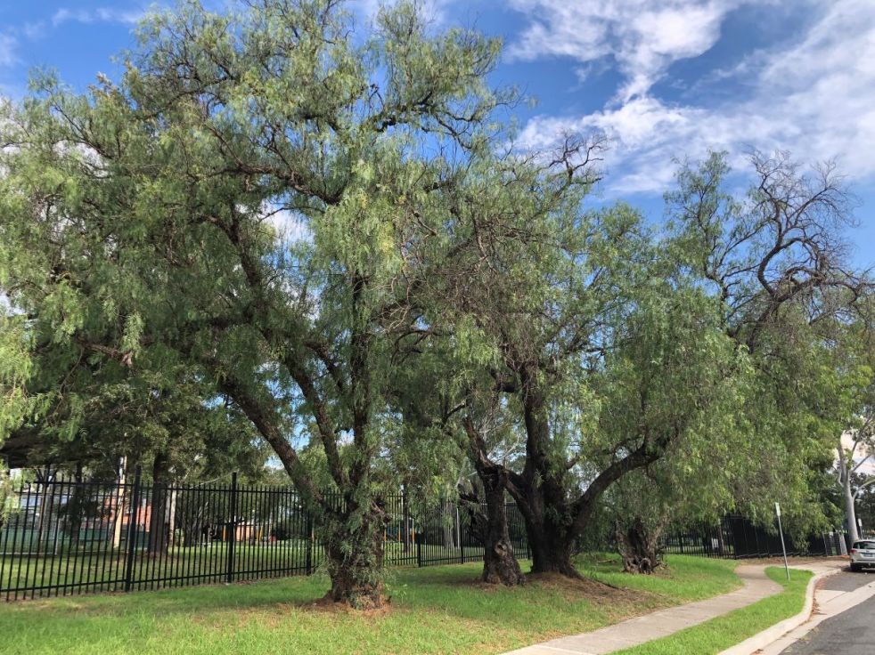
Camden pepper trees, a remnant of the past

Cultural plantings define local landscape

In the 1890s, Camden Municipal Council started beautifying the town area by planting various trees, including peppercorns. These cultural plantings defined the local urban landscape for decades, yet only a handful remain today.

This is a handsome remnant individual specimen located in the Camden town farm area. The graceful weeping nature of the tree is clearly shown here. This site was a former dairy farm, and many pepper trees indicate the sites of former farms and homesteads that have been abandoned. (I Willis, 2023)

Popular nationwide

In Australian Garden History magazine, John Dwyer writes that the pepper tree (Schinus ariera, syn. Schinus molle) or peppercorn tree has been popular nationwide for over 150 years. Originally from the Americas, from Mexico to Peru, it was first introduced into Australia in the mid-19th century. Country towns across inland New South Wales were supplied with specimens from the 1860s from the Adelaide Botanic Gardens. (Dwyer, 2023)

Remnant pepper grove at the corner of John and Exeter Streets

This remnant grove of pepper trees at the corner of John and Exeter Street on the former Dominish farm block’s site is on the edge of the Camden town centre. The trees were planted in the early 1920s by Elmo Dominish on the corner of their farm block adjacent to the farmhouse. (Sue Lyons Dominish) Their survival is probably due to their location, where they were not a problem to property owners or a traffic hazard. (I Willis, 2023)

A remnant grove of pepper trees was planted in the early 1920s by Elmo Dominish on the corner of his farm block at 3 John Street.

Elmo Dominish (Dominish family)

The Dominish farmhouse at 3 John Street Camden in the mid-20th century. The house would have been built in the late 19th century. The pepper grove was planted adjacent to the house on the RHS of this image. (Dominish Family 2024)

The Dominish family rented the farm from a member of the Whiteman family, and, on Elmo’s marriage to Ivy, he bought the farm block. The family lived in the farmhouse built in the late 19th century.

The Dominish women, Elmo Dominish’s daughters (L_R), Edna, Jean, and Doris, are standing in front of the pepper grove planted by Elmo in the early 1920s. The grove is at the corner of John Street and Exeter Streets on what was the corner of the Dominish farm block located at 3 John Street, now part of Camden Public School. This photograph was taken in 1980. (Dominish family, 2024)

Cowpastures colonial gardens

The pepper tree was one of several exotic and hardy ornamental trees that fascinated the colonial Victorians in Camden. Pepper trees could be found in the fine gardens of the Cowpastures gentry estates.

Cowpastures gardens were shaped by various English garden trends and landscape gardeners, arguably the most important being JC Loudon and his gardenesque movement.   (Landarc 1993).

William Macarthur’s Camden Park Nursery from the 1840s and Francis Ferguson’s Australian Nursery from the 1850s catered to these garden trends and sold plant stock throughout Australia and the Pacific. (Landarc 1993)

Ferguson’s Nursery listed pepper trees for sale in the 1890s, as well as oriental planes, pinus insignus, azaleas, and camellias. (Camden News, 12 March 1896)

Town beautification

Town beautification interested Camden’s civic fathers in the late 19th century, and pepper trees made an excellent street tree. (Landarc 1993)

With a ‘graceful habit,’ pepper trees have an attractive gnarled trunk, grow to about 9-15 metres, have semi-weeping branches and leaves, and have decorative sprays of tiny rose peppery pink berries, which are toxic. (Dwyer, 2023)

Street plantings started in the Camden town area in the mid-1890s, including pepper trees (Camden News, 26 August 1897) and in 1899, the council allocated £10 towards tree planting in Murray Street. (Camden News, 26 June 1899)

St John’s Anglican Church in its hilltop location at the top of John Street Camden. During the 1890s, the street was planted with a mixed avenue of pepper trees, and Monterey pines, and possibly another unidentified species. A heavy timber guard protected each tree from wandering stock’s ravages. These guards cost the council 4/5½d each in 1898.
(Kerry & Co c1890s/Camden Images/Landarc 1993)

In 1898, council alderman HP Reeves donated 60 pepper trees to be planted in Elizabeth and Mitchell Streets. Alderman Downers donated a further 150 assorted trees. The council paid for heavy-duty tree guards at 4/5½d each to protect the trees from roaming stock in the town area. (Camden News, 18 May 1939)

The new Camden Cottage Hospital board decided to beautify the hospital grounds by removing the native trees and planting ornamental exotics, including pepper trees and pines. (Camden News, 28 June 1906, 18 August 1910)

Pepper trees were included in advice from the NSW Director of Forests on shelter and the beautification of farm homesteads. Shade trees provided ‘a picturesque air’ and beautified an area, and directions were provided on tree types, planting, care and maintenance. (Picton Post, 23 August 1911)

Beetles stripped pepper trees of foliage in the town at the end of the First World War, and the Camden press provided advice on how to deal with the infestation. Apparently, by taking a long pole to the tree in the early morning, the beetles would fall to the ground and be devoured by the chooks. (Camden News, 18 December 1919)

This image shows mature pepper trees outside the Camden Total Abstinence Benefit Society Hall in John Street in 1903 (Camden Images)

Problems and removal of pepper trees

By the 1920s, pepper trees were becoming a problem, with intrusive roots entering the unformed gutters on the roadsides in the town area. Other people objected to their presence. Dr West was granted permission by the council to replace a pepper tree at the front of Macaria in John Street with a hitching post. (Camden News, 23 February 1922)

Pepper tree showing drooping leaves and gnarled trunk in Edward St (I Willis, 2023)

The following year, the council parks committee decided that pepper trees were starting to pose a problem in the town area. The committee recommended the removal of pepper trees in John Street in front of Mr Pike’s residence, outside the stables of the Commercial Bank, the entrance of Dr West’s premises Macaria, one tree outside the Police Barracks, the removal of two trees in Murray Street and other sites in the town area. The council decided only to remove trees that had caused property damage. Aldermen were concerned that the council would be inundated with requests to remove all pepper trees in the town area. (Camden News, 23 March 1922)

Requests to the council to remove pepper trees came from landholders, the Mains Road authority, and the police. Trees were a traffic hazard along Argyle Street between Edward Street and the Cowpastures bridge, causing property damage in Mitchell Street, Menangle Street, John Street and other locations. (Camden News, 4 May 1939, 27 July 1939)

Trimming of the pepper tree hedges continually preoccupied the hospital board  (Camden News, 20 June 1912). By the 1930s, the trees were causing problems, prompting their removal from the hospital grounds. (Camden News, 17 April 1930)

Remnant trees

Dwyer states that there are often remnant specimens of pepper trees of cultural plantings on abandoned farms, railways and other sites across Australia. (Dwyer, 2023) In the Camden town area, there are remnant stands of pepper trees with some handsome individual specimens, while there have been newer plantings at the civic centre.

A grove of newer plantings of pepper trees outside the Camden Civic Centre. Pepper trees still provide a handsome addition to a civic building where they will not pose a problem. (I Willis, 2023)

Greg Frawley writes:

I went to school at St Paul in the mid-50s and there were several mature pepper trees in front of the original classroom building. With a square of timber seating underneath each pepper tree the strong scent kept flies and insects away when we were eating our Vegemite sandwiches.

I think that is the real reason they were so popular in the early years. Planted near homes – particularly back doors to keep flies away. We planted one in Narellan 46 years ago for this purpose. Although it never grew very big, it gave off a wonderful scent.

Email 21 April 2023

Francis Warner writes:

Love these trees. Our first house at Camden Park was Stables Cottage. Had a carport and outdoor picnic area under a peppercorn. The fragrance was soothing, and the seeds looked so pretty.

Email 29 April 2023

References

John Dwyer 2023, ‘Schinus molle var. areira, Peppertree, Peruvian peppertree, peppercorn tree’. Australian Garden History, vol. 34, no. 4, April, pp22-25

Landarc Landscape Architects 1993, Camden Significant Trees and Vegetated Landscape Study. Camden, Camden Municipal Council.

Updated 23 February 2024. Originally posted 8 April 2023.