

The Camden story
The Camden story is an ongoing project that aims to tell the untold stories of the Camden, Cowpastures and Macarthur districts. There is the telling, the learning and the showing of the story.
The project is constantly evolving and changing direction. It is centred around the construction of place and the meaning of landscape. These are culturally derived concepts from both Indigenous and European experiences.

There are the natural ecologies that make up the environment as well as atmospheric and geological elements. The natural elements are just as important as the cultural.
Complexities of the Camden story
The Camden story has its own complexities. There is no one single dominant narrative. There are many voices in the story and each has a right to be heard.
There are many threads to the Camden story and when woven together make a coherent story with many voices. The weave of the cloth represents the warp and weft of the daily lives of the actors on the stage. Together they create a vibrant design that can capture the imagination of many and inspire others.
There are many actors in the constantly evolving narrative, each with their own agenda. The story is played on a stage that is located on Sydney’s rural-urban fringe, a dynamic movable frontier on the city’s edge. It is a constantly changing and evolving cultural landscape.
There are many layers to the Camden story each with its own particularities. As each layer is peeled back it reveals memories and meanings from the past that influence the present. Those who are interested can dive into the many layers and help unravel the entangled threads of the web and give some clarity to their meaning within the story.
The Camden story is a journey that is constantly evolving with many signposts along the way. There are a lot of fellow travellers who have their own stories. There are many pathways and laneways to go down, each with its own meaning and memories to the travellers who come along for the journey.
The Camden story has its own road map of sorts with signposts and markers of significant places along the journey for those who want to look. There are many opportunities for those who want embark on this journey and uncover many of the undiscovered mysteries of the Camden story.
It is in the interests of those who want to tell the story that they walk the ground in which the story is embedded. The landscape speaks to those who want to listen. The experience is enriching and fulfilling and shapes the telling of the story.
Some parts of the Camden story
The Camden story has many parts and some are listed below:
Camden, the town
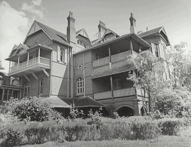
This is a short history of the town, which is situated on the floodplain of the Nepean River, on the traditional land of the Dharawal people in an area known as the Cowpastures. The Camden area’s distinctive landscape has moulded the community’s identity and sense of place. From the earliest days of European settlement class and social networks ordered daily life in the village with the local gentry at the top of the social hierarchy.

A field of dreams, the Camden district, 1840-1973
The Camden district ran from the Main Southern Railway around the estate village of Menangleinto the gorges of the Burragorang Valley in the west. It was a concept created by the links between peoples’ social, economic and cultural lives across the area. The district became the centre of people’s daily lives for well over a century and the basis of their sense of place and community identity.
Making Camden History, a brief historiography of the local area
This short historiography is one of the few that has been attempted to illustrate the construction of the history of a rural community. It is an attempt to examines the broad range of influences that shaped the writing of the Camden community’s history.
Movie making Camden style
Movie makers have always had an eye on the Camden district’s large country houses, rustic farm buildings, quaint villages and picturesque countryside for film locations. From the 1920s the area has been used by a series of film makers as a setting for their movies. It coincided was an increasing interest in the area’s Englishness from poets, journalists and travel writers.

Camden Bibliography a biography of a country town
The Camden bibliography is an attempt to highlight some of the research that addresses the notion of Camden as a country town and the subsequent urbanisation of the local government area. The sources listed in the bibliography cover the geographic area of the Camden district.
The Cowpastures Project
This is a summary of the blog posts from Camden History Notes on the Cowpastures.
The Cowpastures Region 1795-1840
The Cowpastures emerged as a regional concept in the late 18th century starting with the story of the cattle of the First Fleet that escaped their captivity at the Sydney settlement. The region was a culturally constructed landscape that ebbed and flowed with European activity. It grew around the government reserve established by Governors Hunter and King. It then developed into a generally used locality name centred on the gentry estates in the area.

Convicts in the Cowpastures
The story of European settlement in the Cowpastures is intimately connected to the story of the convicts and their masters. This story has not been told and there is little understanding of the role of the convicts in the Cowpastures district before 1840. Who were they? What did they do? Did they stay in the district?
Kirkham, a locality history
Kirkham is a picturesque, semi-rural locality on Sydney’s rural-urban fringe between the historic township of Camden, with its inter-war and colonial heritage and the bustling commercial centre of Narellan. The arrival of the rural-urban fringe at Kirkham in recent decades has created a contested site of tension and constant change, resulting in an ever-evolving landscape. This is an example of a short locality history within the local area published by the Dictionary of Sydney.
‘Just like England’, a colonial settler landscape
Early European settlers were the key actors in a place-making exercise that constructed an English-style landscape aesthetic on the colonial stage in the Cowpastures district of New South Wales. The aesthetic became part of the settler colonial project and the settlers’ aim of taking possession of territory involving the construction of a cultural ideal from familiar elements of home in the ‘Old Country’. The new continent, and particulaly the bush, had the elements of the Gothic with its grotesque and the demonic, and the landscape aesthetic was one attempt to counter these forces. Settlers used the aesthetic to assist the creation of a new narrative on an apparenty blank slate and in the process dispossessed and displaced the Indigenous occupants. The new colonial landscape was characterised by English place-names, English farming methods and English settlement patterns, with only cursory acknowledgement of Indigenous occupation.
Townies, ex-urbanites and aesthetics: issues of identity on Sydney’s rural-urban fringe
The rural-urban fringe is a dynamic frontier, an ever expanding zone of transition on the edges of Australia’s major cities and regional centres. This paper examines the proposition that Sydney’s urban growth has pushed the city’s rural-urban fringe into the countryside and unleashed the contested nature of place-making in and around the
country town of Camden. It will be maintained that the dynamic forces that characterise the rural-urban frontier have resulted a collision between the desires and aspirations of ‘locals’ and ‘outsiders’ and prompted a crisis in the identity of place. Community icons
and rituals have become metaphors for the continuity of values and traditions that are embedded in the landscapes of place. The actors have used history and heritage, assisted by geography and aesthetics, to produce a narrative that aims to preserve landscape identity, and has created a cultural myth based on a romantic notion of an idealised
country town drawn from the past, ‘a country town idyll’.

Westies, Bogans and Yobbos. What’s in a name?
What’s in a name? Quite a lot if you live in the fringe urban communities of Campbelltown, Camden or Picton in the Macarthur district on Sydney’s rural-urban fringe. In the past these communities have been fiercely parochial country towns with clearly identifiable differences based on history, heritage, traditions, mythology, rituals, demographics, local government and a host of other factors. With the encroachment of Sydney’s urban sprawl they have been wrapped up by the tentacles of the metropolitan octopus and faced challenges on a variety of fronts. The questions that this article raises concern Macarthur regionalism. Is it authentic? How representative is it of the former country towns that are now incorporated within it?
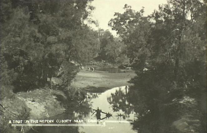
Nepean River more than a water view
The Nepean River is one of the most important waterways in the Sydney basin and has particular significance for Sydney’s southwestern rural-urban fringe. The Nepean River catchment extends south and east of the Sydney Basin to take in areas near Robertson and Goulburn. West of Wollongong the tributaries includng Cataract Creek, Avon River, Cordeaux River that flow north-west and then into the deep gorges of Pheasants Nest and Douglas Park. The river opens up into a floodplain and flows past Menangle and crosses the Cowpastures and southern Cumberland Plain past Camden and Cobbitty. The river then flows north through the gorge adjacent to Wallacia and enters Bents Basin before it is joined by the Warragamba River and changes its name to the Hawkesbury River.
The Women’s Voluntary Services, A Study of War and Volunteering in Camden, 1939-1945
Camden is a country town whose history and development has been influenced by war. The town was part of Australia’s homefront war effort, and from the time of the Boer War the most important part of this for Camden was volunteering. The Second World War was no exception, and the most influential voluntary organisation that contributed to the town’s war effort was the Womens Voluntary Services [WVS]. The Camden WVS was part of a strong tradition of Victorian female philanthropy in the town, which attracted, and depended on, middle class women socialised in Victorian notions of service, ideals of dependence, a separatedness of spheres, patriarchy, the status quo, and by the inter-war period, modernity.
The Member for Camden, Dr Elizabeth Kernohan
On 21 October 2004 the former Member for Camden, Dr Elizabeth (Liz) Kernohan, died after suffering a heart attack. She was sixty- five. Thousands of people lined Argyle Street in Camden to see the cortege and pay their last respects, I and compliments flowed from both sides of New South Wales politics. There were over 1850 column centimetres devoted to her death and subsequent funeral in the local press. Kernohan was a popular, larger than life figure in Camden. She held the seat of Camden for the Liberal party for over 11 years in an area that some have claimed is the key to the success of the Howard Government. How was Kernohan able to gain this type of support? This paper will try to address this question, although initially it is useful to give a brief overview of the electorate.
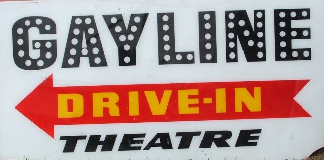
Narellan ‘Gayline’ Drive-In Movie Theatre
A notable part of Camden modernism that has disappeared is the drive-in movie theatre. The Narellan Gayline Drive-in Movie Theatre was one of the notable attractions in the local area between the 1960s and 1980s located on Morshead Road, Narellan (now Narellan Vale). Along with rock ‘n roll, transistor radios, the bikini, the mini-skirt, it marked the lifestyle of the baby boomers. Always popular with teenagers and young families. The drive-in movie theatre was a defining moment in the district for a 20th century culture that was based around the icons of the period: cars and movies.
El Caballo Blanco, A Forgotten Past
Catherine Fields once boasted a national tourist facility which attracted thousands of visitors a year to the local area, the El Caballo Blanco entertainment complex. The El Caballo Blanco complex opened in April 1979 at Catherine Fields. The main attraction was a theatrical horse show presented with Andalusian horses, which was held daily in the large 800-seat indoor arena.
CWA Camouflage Netting Volunteers
The Camden Country Women’s Association made camouflage nets during the Second World War and was the largest netting centre in the area. The Camden CWA camouflage netting centre was assisted by sub-branches at Campbelltown and Narellan, which were established after the joint CWA-WVS meeting in December 1941.
The Camden Branch Railway Line
One of the most popular memories of the Camden area by locals and visitors alike is the Camden branch line and its famous locomotive Pansy. It has a truly dedicated and enthusiastic bunch of supporters who positively drool about it and overlook its foibles. Old timers tell and retell stories to anyone who wants to listen, all laced with a pinch of exaggeration and the romantic. A part of local nostalgia. The Camden branch line was operated by the New South Wales Railways from 1882 to its closure in 1963.

New horizons open up for the new community of Oran Park and the finishing line for the former Oran Park Raceway
Oran Park Raceway was doomed in 2008 to be part of history when it was covered with houses in a new suburb with the same name. It was also the name of a former pastoral property that was part of the story of the settler society within the Cowpastures. The locality is the site of hope and loss for both locals and new arrivals. The Oran Park Motor Racing Circuit was located in the south-western and western part of the original Oran Park pastoral estate. The main grand prix circuit was 2.6 km long with a mixture of slow, technical and fast sweeping corners as well as changes in elevation around the track.
The local ‘rag’, the future of local newspapers
This post was prompted by an item in the Oran Park Gazette, an A4 newsletter newspaper. Gazette journalist Lisa Finn-Powell asked: What is the future of the community newspaper? The local ‘rag’ in our suburb is a free tabloid newspaper thrown onto our front driveway each week. Actually there are two of them, the Camden Narellan Advertiser and the Macarthur Chronicle. Where I live some of these newspapers stay on the neighbour’s driveway for weeks and disintegrate into a mess. Other neighbours just put them in the bin. So not everyone is a fan of the local ‘rag’ in the age of Snapchat, Instagram and Facebook.
32 Squadron RAAF, Camden Airfield, 1942-1944
The members of 32 Squadron arrived in Camden Airfield in September 1942 after seven months of hazardous operational duties supporting Allied Forces in New Guinea and the surrounding area, including New Britain. The squadron had been ‘hastily formed in the field’ in February 1942 with personnel drawn from other units. The squadron’s operational duties at Camden Airfield included reconnaissance and sea patrols off the east coast of Australia.
The army in camp at Narellan in WW2
Once the army moved into Narellan Military Camp it commenced operation and became part of the wartime scene during WW2. Men were seen marching all over the district, there were mock raids and the men practiced firing small arms. The camp is an important part of the story of Narellan during war as thousands of men, and some women, moved through the camp on their way to somewhere in the theatre that was the Second World War.

Modernism and consumerism, supermarkets come to Camden
Supermarkets are one of the ultimate expressions of modernism. The township of Camden was not isolated from these global forces of consumerism that originated in the USA. The Camden community was bombarded daily with American cultural influences in the form of movies, motor cars, drive-in, motels, TV, and radio. Now consumerism was expressed by the appearance of self-service retailing and the development of the supermarket.
Camden Cafes and Milk Bars
The local milk bar is a largely unrecognized part of Camden modernism where the latest trends in American food culture made their way into the small country town by Australian-Greek immigrants. The design, equipment and fit-out of local cafes and milk bars was at the cutting edge of Interwar fashion. The cafes were a touch of the exotic with their Art Deco style interiors, where fantasy met food without the social barriers of daily life of the Interwar period. Camden milk bars rarely just sold milk shakes unlike their counterparts in the city. To make a living and ensure that their businesses paid their way the cafes and milk bars also sold fruit and vegetables, meals, sandwiches, lollies, sweets and chocolates.
Interwar Camden
The interwar period in Camden was a time of economic development and material progress. The prosperity of the period was driven by the local dairy industry and the emerging coal industry. During the interwar period one of the most important economic arteries of the town was the Hume Highway (until 1928 the Great South Road). For a country town of its size the town had modern facilities and was up-to-date with the latest technology. The interwar years were a period of transition and increasingly the motor car replaced the horse in town, and on the farm the horse was replaced by the tractor, all of which supported the growing number of garages in the town.
Discover more from Camden History Notes
Subscribe to get the latest posts sent to your email.


One thought on “The Camden story, an evolving project”
Comments are closed.